Minchinbury, New South Wales
| Minchinbury Sydney, New South Wales | |||||||||||||
|---|---|---|---|---|---|---|---|---|---|---|---|---|---|
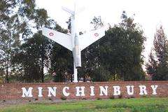 The Jet at Minchinbury | |||||||||||||
| Coordinates | 33°47′00″S 150°50′00″E / 33.7833°S 150.8333°ECoordinates: 33°47′00″S 150°50′00″E / 33.7833°S 150.8333°E | ||||||||||||
| Population | 5,453 (2011 census)[1] | ||||||||||||
| Postcode(s) | 2770 | ||||||||||||
| Location | 39 km (24 mi) west of Sydney | ||||||||||||
| LGA(s) | City of Blacktown | ||||||||||||
| State electorate(s) | Mount Druitt | ||||||||||||
| Federal Division(s) | McMahon | ||||||||||||
| |||||||||||||
Minchinbury is a suburb in western Sydney, in the state of New South Wales, Australia. Minchinbury is located 39 kilometres west of the Sydney central business district, in the local government area of the City of Blacktown and is part of the Greater Western Sydney region.
Minchinbury is predominantly a residential area with a small commercial/retail area in the centre and industrial/commercial zones in the westernmost part.[2]
History
Minchinbury takes its name from the property named by Capt. William Minchin who was granted 1,000 acres (4.0 km2) here in 1819. William Minchin was the Principal Superintendent of Police and Treasurer of the Police Fund in the colony. After the death of William in 1821, the property passed to his only daughter Maria Matilda. In 1838, Maria Matilda and her family were lost at sea, leaving no descendants of William Minchin alive.
Dr. Charles McKay purchased the property in 1859 and developed it into vineyards and cellars. Over the next 2 decades, Dr. McKay bought many neighbouring properties and in 1881, he put all of his land up for auction. At this time, the land did not sell and it wasn't until 1895 that James Angus bought all of McKay's properties.
Penfolds Pty. Ltd. purchased the winery and vineyards in 1912. Most of the existing buildings at the winery were probably added while under the ownership of Penfolds. In 1898, during James Angus's winemaking years, the vineyards suffered a viral disease that destroyed the vines. New vines were planted and grew until 1962 when soil erosion made them useless. New vineyards were established on other properties around the area to supply the fruit for the winery. Minchinbury Winery became famous for its champagne. Penfolds stopped operations at the winery in 1978.[3]
James Angus died at Rooty Hill on April 13 1916 after being hit by the morning train.[4]
Demographics
- According to the 2011 Census data, the most common ancestries are Australian 19.4%, English 16.9%, Filipino 9.3%, Maltese 4.8% and Indian 4.0%.
- 60.6% of people were born in Australia. The most common countries of birth were Philippines 8.2%, Fiji 2.9%, New Zealand 2.5%, England 1.9% and India 1.8%.
- The most common responses for religion in Minchinbury were Catholic 40.1%, Anglican 14.7%, No Religion 7.8%, Islam 7.2% and Hinduism 3.2%.
- 61.6% of people only spoke English at home. Other languages spoken at home included Tagalog 5.7%, Hindi 3.4%, Arabic 3.4%, Filipino 2.3% and Urdu 1.7%.
Landmarks
Along the southern side of the Great Western Highway there are two notable landmarks:
- The previous entrance to Penfolds Winery remains in the form of the masonry work on either side of the gate, at the top of the hill between Willis Street and Beaconsfield Road
- A facsimile of the original CAC Avon Sabre jet aircraft (that had been installed at the entrance to the vinery in 1955 with the accompanying sign "Don't Crash, Drink Penfolds") is mounted about 10 m off the ground, in a nearly vertical manner, at the intersection of the Great Western Highway and Minchin Drive (adjacent to Minchinbury Reserve).
The original plane was placed there by Penfolds in the 1930s when they acquired it from Cliff Carpenter, who built it but only flew it once. It was originally crashed nose into the ground with the sign painted on the underside of the wings.[5]
Commercial area
Minchinbury Shopping Centre is located on the corner of Macfarlane Drive and Minchin Drive and features a supermarket and specialty shops including a fish and chip shop and liquor store.[6]
Transport
The Great Western Highway runs along the northern border, while the M4 Western Motorway runs along the southern border. The Westlink M7 Motorway runs along the eastern border. There is a regular bus service (Busways 739) to Mount Druitt and another bus service (739V) runs through Mount Druitt Village.
Schools
Minchinbury Public School serves Kindergarten students through to Year 6.
Sporting clubs
Minchinbury features clubs for Soccer, Cricket, Athletics and Rugby League (Minchinbury Jets JRLC).
Geology
Minchinbury is the type location of the Minchinbury Sandstone.
References
- ↑ Australian Bureau of Statistics (31 October 2012). "Minchinbury (State Suburb)". 2011 Census QuickStats. Retrieved 25 April 2015.
- ↑ http://www.blacktown.nsw.gov.au/our-city/statistics/suburb-profiles.cfm The 2001 City of Blacktown Social Plan
- ↑ http://www.blacktown.nsw.gov.au/our-city/history/the-landmarks/minchinbury-winery.cfm Minchinbury History Article on Blacktown City Council web site
- ↑ Trove
- ↑ tv program "Very Short War" ABC 2010
- ↑ http://www.airviewonline.com.au/stock-photographs/Default.asp?Pr=303 Airview Online view and record of industrial areas
External links
| Wikimedia Commons has media related to Minchinbury, New South Wales. |