Missouri's congressional districts
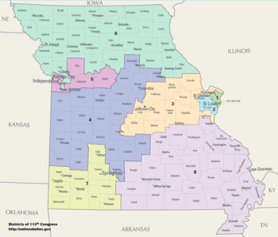
Missouri is currently divided into 8 congressional districts, each represented by a member of the United States House of Representatives.
Due to the 2010 Census Missouri lost a Congressional seat in 2013. Initial redistricting maps show the biggest impact being in the 3rd Congressional District (which includes portions of St. Louis which had large population losses in the Census). The district would effectively become part of the 1st District. The largely rural 9th District, which also suffered population decreases and is being dissolved, would become part of the 6th District north of the Missouri River and part of a redrawn more rural 3rd district south of the river.[2]
Current districts and representatives
List of members of the Missourian United States House delegation, their terms, their district boundaries, and the districts' political ratings according to the CPVI. The delegation has a total of 8 members, including 6 Republicans and 2 Democrats.
| District | Representative | Party | CPVI | Incumbency | District map |
|---|---|---|---|---|---|
| 1st | 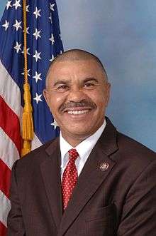 William Clay Jr. (D-St. Louis) William Clay Jr. (D-St. Louis) |
Democratic | D+28 | January 3, 2001 – present | .tif.png) |
| 2nd |  Ann Wagner (R-Ballwin) Ann Wagner (R-Ballwin) |
Republican | R+8 | January 3, 2013 – present | .tif.png) |
| 3rd |  Blaine Luetkemeyer (R-Jefferson City) Blaine Luetkemeyer (R-Jefferson City) |
Republican | R+13 | January 3, 2009 – present | .tif.png) |
| 4th | 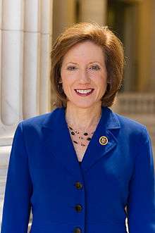 Vicky Hartzler (R-Columbia) Vicky Hartzler (R-Columbia) |
Republican | R+13 | January 3, 2011 – present | .tif.png) |
| 5th |  Emanuel Cleaver (D-Kansas City) Emanuel Cleaver (D-Kansas City) |
Democratic | D+9 | January 3, 2005 – present | .tif.png) |
| 6th |  Sam Graves (R-Tarkio) Sam Graves (R-Tarkio) |
Republican | R+12 | January 3, 2001 – present | .tif.png) |
| 7th |  William Long (R-Springfield) William Long (R-Springfield) |
Republican | R+19 | January 3, 2011 – present | .tif.png) |
| 8th |  Jason Smith (R-Salem) Jason Smith (R-Salem) |
Republican | R+17 | June 4, 2013 – present | .tif.png) |
Historical and present district boundaries
Table of United States congressional district boundary maps in the State of Missouri, presented chronologically.[3] All redistricting events that took place in Missouri between 1973 and 2013 are shown.
| Year | Statewide map | St. Louis highlight |
|---|---|---|
| 1973 – 1982 |  |
%2C_1973_%E2%80%93_1982.tif.png) |
| 1983 – 1992 | 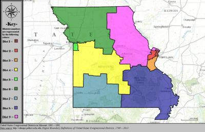 |
%2C_1983_%E2%80%93_1992.tif.png) |
| 1993 – 2002 |  |
%2C_1993_%E2%80%93_2002.tif.png) |
| 2003 – 2013 |  |
%2C_2003_%E2%80%93_2013.tif.png) |
| Since 2013 | 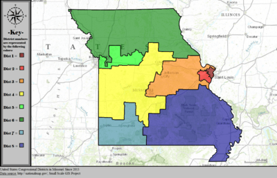 |
%2C_since_2013.tif.png) |
Obsolete Districts
The following list includes districts which are no longer in use in Missouri, due to Missouri's decrease in population relative to the United States at large in recent times.
- Missouri's 9th congressional district, obsolete since 2010 census
- Missouri's 10th congressional district, obsolete since 1980 census
- Missouri's 11th congressional district, obsolete since 1960 census
- Missouri's 12th congressional district, obsolete since 1950 census
- Missouri's 13th congressional district, obsolete since 1950 census
- Missouri's 14th congressional district, obsolete since 1930 census
- Missouri's 15th congressional district, obsolete since 1930 census
- Missouri's 16th congressional district, obsolete since 1930 census
- Missouri's At-large congressional seat, obsolete since 3 January 1935
- Missouri Territory's At-large congressional seat, obsolete since statehood in 1821
See also
References
- ↑ "The national atlas". nationalatlas.gov. Retrieved February 2, 2014.
- ↑ "UPDATE: House Redistricting Committee Unveils Map". OzarksFirst.com. Retrieved 2011-03-31.
- ↑ "Digital Boundary Definitions of United States Congressional Districts, 1789-2012.". Retrieved October 18, 2014.