Jefferson City, Missouri
| Jefferson City, Missouri | |||
|---|---|---|---|
| State capital | |||
| City of Jefferson | |||
 | |||
| |||
| Nickname(s): Jeff City, JC, Jeff, or JCMO | |||
| Motto: Jefferson City | |||
 | |||
 U.S. Census Map | |||
| Coordinates: 38°34′36″N 92°10′25″W / 38.57667°N 92.17361°WCoordinates: 38°34′36″N 92°10′25″W / 38.57667°N 92.17361°W | |||
| Country | United States | ||
| State | Missouri | ||
| Counties | Callaway, Cole | ||
| Founded | 1821 | ||
| Incorporated | 1825 | ||
| Named for | Thomas Jefferson, the third President of the United States | ||
| Government[1][2] | |||
| • Type | Mayor-council | ||
| • Mayor | Carrie Tergin | ||
| • Administrator | Steve Crowell | ||
| • City Clerk | Phyllis Powell | ||
| Area[3] | |||
| • State capital | 37.58 sq mi (97.33 km2) | ||
| • Land | 35.95 sq mi (93.11 km2) | ||
| • Water | 1.63 sq mi (4.22 km2) | ||
| Elevation | 630 ft (192 m) | ||
| Population (2010)[4] | |||
| • State capital | 43,079 | ||
| • Estimate (2012[5]) | 43,183 | ||
| • Density | 1,198.3/sq mi (462.7/km2) | ||
| • Metro | 149,807 | ||
| Time zone | CST (UTC-6) | ||
| • Summer (DST) | CDT (UTC-5) | ||
| ZIP codes | 65101-65111 | ||
| Area code(s) | 573 | ||
| FIPS code | 29-37000[6] | ||
| GNIS feature ID | 0758233[7] | ||
| Website | http://www.jeffersoncitymo.gov/ | ||


Jefferson City is the capital of the State of Missouri and the fifteenth most populous city in the state.[8] It is also the county seat of Cole County and the principal city of the Jefferson City Metropolitan Statistical Area. Jefferson City is named for Thomas Jefferson, the third president of the United States. Jefferson City currently holds the title of America's "Most Beautiful Small Town", given by Rand McNally.[9]
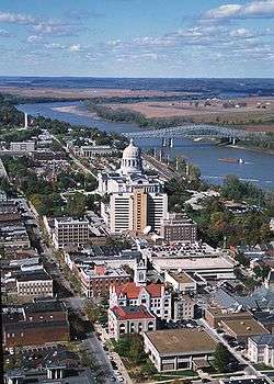
Jefferson City is on the northern edge of the Ozark Plateau on the southern side of the Missouri River in a region known as Mid-Missouri. It is also at the western edge of one of the major wine-producing regions of the Midwest, the Missouri Rhineland. The city is dominated by the domed Capitol, which rises from a bluff overlooking the Missouri River to the north; Lewis and Clark passed the bluff on their historic expedition upriver before Europeans established any settlement there.
Often referred to as "JCMO", "Jeff City", "Jeff", "Jefferson", or "JC", many of Jefferson City's primary employers fall within the service and manufacturing industries, similar to other Midwestern capital cities. Jefferson City is also home to Lincoln University, a public historically black land-grant university founded in 1866 by the 62nd Regiment of U.S. Colored Troops with additional support from the 65th Regiment of U.S. Colored Troops.
History

.jpg)
In pre-Columbian times, this region was home of an ancient people known only as the "Mound Builders". They were no longer present by the time of the first settlers, having been replaced by Osage Indians. When the Missouri Territory was organized in 1812, St. Louis was Missouri's seat of government, and St. Charles would serve as the next capital.
In the middle of the state, Jefferson City was chosen as the new capital in 1821 when Thomas Jefferson was still living. The village first was called "Lohman's Landing", and when the legislature decided to relocate there, they proposed the name "Missouriopolis" before settling on "Jefferson City".[11] For years, this village was little more than a trading post located in the wilderness about midway between St. Louis and Kansas City. In 1825, the settlement was incorporated as a city and a year later, the Missouri legislature first met in Jefferson City.
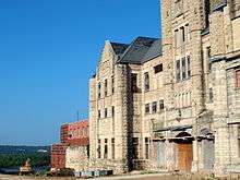
Jefferson City was chosen as the site of a state prison. This prison, named the Missouri State Penitentiary, opened in 1836. This prison was home to multiple infamous Americans, including former heavyweight champion Sonny Liston, assassin James Earl Ray, and bank robber Charles "Pretty Boy" Floyd. During the Civil War, Jefferson City was occupied by Union troops and the elected state legislature was driven from Jefferson City by Union General Nathaniel Lyon. Some of the legislators later reconvened in Neosho, Missouri and passed an ordinance of secession. Missouri was claimed by both the Confederacy and the Union, just like the neighboring state Kentucky. Missourians were strongly divided and many people in the state—especially in St. Louis—supported the Union, while other areas (such as Missouri's Little Dixie) were strongly pro-Confederate along the Missouri river between Jefferson City and Kansas City.
German immigrants created vineyards in small towns on either side of the Missouri River, especially on the north from the city east to Marthasville, located outside of St. Louis. Known as the "Missouri Rhineland" for its vineyards and first established by German immigrants in the mid-1800s, this region has become part of the agricultural and tourist economy.
Geography
According to the United States Census Bureau, the city has a total area of 37.58 square miles (97.33 km2), of which, 35.95 square miles (93.11 km2) is land and 1.63 square miles (4.22 km2) is water.[3]
Climate
Jefferson City has a transitional climate between a humid subtropical and humid continental climate with hot, rainy summers and cold winters. Thunderstorms are common in both the spring and summer. Light snow is common during the winter, although about half of wintertime precipitation falls as rain.[12]
| Climate data for Jefferson City, Missouri, 1981–2010 normals | |||||||||||||
|---|---|---|---|---|---|---|---|---|---|---|---|---|---|
| Month | Jan | Feb | Mar | Apr | May | Jun | Jul | Aug | Sep | Oct | Nov | Dec | Year |
| Record high °F (°C) | 79 (26) |
89 (32) |
97 (36) |
96 (36) |
102 (39) |
105 (41) |
112 (44) |
111 (44) |
107 (42) |
96 (36) |
87 (31) |
79 (26) |
112 (44) |
| Average high °F (°C) | 39.9 (4.4) |
45.4 (7.4) |
55.5 (13.1) |
66.7 (19.3) |
75.1 (23.9) |
83.5 (28.6) |
88.3 (31.3) |
87.8 (31) |
79.8 (26.6) |
68.5 (20.3) |
55.8 (13.2) |
42.5 (5.8) |
65.7 (18.7) |
| Average low °F (°C) | 19.9 (−6.7) |
23.6 (−4.7) |
32.2 (0.1) |
43.1 (6.2) |
53.1 (11.7) |
62.8 (17.1) |
67.2 (19.6) |
65.4 (18.6) |
56.0 (13.3) |
44.0 (6.7) |
33.9 (1.1) |
23.0 (−5) |
43.7 (6.5) |
| Record low °F (°C) | −20 (−29) |
−13 (−25) |
−16 (−27) |
13 (−11) |
24 (−4) |
38 (3) |
42 (6) |
41 (5) |
29 (−2) |
14 (−10) |
1 (−17) |
−21 (−29) |
−21 (−29) |
| Average precipitation inches (mm) | 1.93 (49) |
2.29 (58.2) |
3.00 (76.2) |
4.16 (105.7) |
5.18 (131.6) |
4.39 (111.5) |
4.31 (109.5) |
3.99 (101.3) |
4.15 (105.4) |
3.35 (85.1) |
3.61 (91.7) |
2.67 (67.8) |
43.03 (1,093) |
| Average snowfall inches (cm) | 4.8 (12.2) |
3.4 (8.6) |
1.4 (3.6) |
.1 (0.3) |
0 (0) |
0 (0) |
0 (0) |
0 (0) |
0 (0) |
0 (0) |
.3 (0.8) |
3.8 (9.7) |
13.8 (35.2) |
| Source: NOAA | |||||||||||||
Demographics
| Historical population | |||
|---|---|---|---|
| Census | Pop. | %± | |
| 1860 | 3,082 | — | |
| 1870 | 4,420 | 43.4% | |
| 1880 | 5,271 | 19.3% | |
| 1890 | 6,742 | 27.9% | |
| 1900 | 9,664 | 43.3% | |
| 1910 | 11,850 | 22.6% | |
| 1920 | 14,490 | 22.3% | |
| 1930 | 21,596 | 49.0% | |
| 1940 | 24,268 | 12.4% | |
| 1950 | 25,099 | 3.4% | |
| 1960 | 28,228 | 12.5% | |
| 1970 | 32,407 | 14.8% | |
| 1980 | 33,619 | 3.7% | |
| 1990 | 35,481 | 5.5% | |
| 2000 | 39,636 | 11.7% | |
| 2010 | 43,079 | 8.7% | |
| Est. 2015 | 43,169 | [15] | 0.2% |
| U.S. Decennial Census | |||
2010 census
As of the census[4] of 2010, there were 43,079 people, 17,278 households, and 9,969 families residing in the city. The population density was 1,198.3 inhabitants per square mile (462.7/km2). There were 18,852 housing units at an average density of 524.4 per square mile (202.5/km2). The racial makeup of the city was 78.0% White, 16.9% African American, 0.3% Native American, 1.8% Asian, 0.1% Pacific Islander, 0.8% from other races, and 2.2% from two or more races. Hispanic or Latino of any race were 2.6% of the population.
There were 17,278 households of which 28.8% had children under the age of 18 living with them, 41.6% were married couples living together, 12.4% had a female householder with no husband present, 3.7% had a male householder with no wife present, and 42.3% were non-families. 36.2% of all households were made up of individuals and 11.5% had someone living alone who was 65 years of age or older. The average household size was 2.21 and the average family size was 2.89.
In the city the population was spread out with 20.9% of residents under the age of 18, 10.3% between the ages of 18 and 24, 28.6% from 25 to 44, 26.8% from 45 to 64, and 13.4% who were 65 years of age or older. The median age in the city was 37.5 years. The gender makeup of the city was 51.2% male and 48.8% female.
2000 census
As of the census[6] of 2000, there were 39,636 people, 15,794 households, and 9,207 families residing in the city. The population density was 1,454.4 people per square mile (561.6/km²). There were 16,987 housing units at an average density of 623.3 per square mile (240.7/km²). The racial makeup of the city was 81.50% White, 14.70% Black or African American, 0.38% Native American, 1.23% Asian, 0.05% Pacific Islander, 0.62% from other races, and 1.52% from two or more races. 1.55% of the population were Hispanic or Latino of any race.
There were 15,794 households of which 27.9% had children under the age of 18 living with them, 44.4% were married couples living together, 10.8% had a female householder with no husband present, and 41.7% were non-families. 36.1% of all households were made up of individuals and 11.9% had someone living alone who was 65 years of age or older. The average household size was 2.21 and the average family size was 2.90.
In the city the population was spread out with 20.9% under the age of 18, 11.0% from 18 to 24, 32.1% from 25 to 44, 22.0% from 45 to 64, and 14.0% who were 65 years of age or older. The median age was 36 years. For every 100 females there were 105.3 males. For every 100 females age 18 and over, there were 106.6 males.
The median income for a household in the city was $39,628, and the median income for a family was $52,627. Males had a median income of $35,050 versus $25,521 for females. The per capita income for the city was $21,268. About 7.3% of families and 11.5% of the population were below the poverty line, including 17.1% of those under age 18 and 7.1% of those age 65 or over.
Government

City Government
The city uses a mayor-council system. The mayor is elected in a citywide vote. The city council has 10 members. Two are elected from each of the city's five wards.
State Government

The State Capitol is located in Jefferson City. In addition, state agencies are headquartered in Jefferson City. The Missouri State Archives is located in Jefferson City.
The Missouri Department of Corrections (MDOC) operates the Jefferson City Correctional Center and the Algoa Correctional Center in Jefferson City.[16][17] The JCCC replaced the Missouri State Penitentiary, which until its closure was the oldest operating penal facility west of the Mississippi River. It served as the State of Missouri's primary maximum security institution,[18] and it housed male death row prisoners until April 1989, when they were moved to the Potosi Correctional Center.[19] The current JCCC was opened on September 15, 2004, replacing the Missouri State Penitentiary.[16]
Federal Government
The United States Postal Service operates several postal facilities, including the Jefferson City Main Post Office.[20]
The U.S. District Court was located in the same building as the U.S. Post Office, which was dedicated in November 1934. The Post Office continues to occupy the building, but the court moved to the Christopher S. Bond U.S. Court House after its dedication on September 27, 2011. The 118,000-square-foot facility overlooking the Missouri River is named for the former U.S. Senator from Missouri and houses the Central Division of the U.S. District and Bankruptcy Courts for the Western District of Missouri. The building was designed to achieve the U.S. Green Building Council’s Leadership in Energy and Environmental Design Gold rating. Sustainable design features include reducing water use by 44 percent, using 13 percent recycled content, diverting 80 percent of construction waste materials from landfills, and it is 36 percent more efficient than current energy standards.[21]
Economy


Top employers
According to the City's 2015 Popular Annual Financial Report,[22] the top employers in the city are:
| # | Employer | # of Employees |
|---|---|---|
| 1 | State of Missouri | 14,208 |
| 2 | Jefferson City Public Schools | 1,556 |
| 3 | Scholastic | 1,400 |
| 4 | Capital Region Medical Center | 1,398 |
| 5 | SSM Health-St. Mary's Hospital | 1,070 |
| 6 | Central Bancompany | 918 |
| 7 | ABB Power T&D Company | 653 |
| 8 | Jefferson City Medical Group | 644 |
| 9 | Wal-Mart Supercenter | 631 |
| 10 | Quaker Window Products | 541 |
| Total | 23,019 | |
Small Business
In 2016, Jefferson City was ranked the fourth Best Small City to Start a Business (out of the 1,268 cities examined nationally).[23] The rankings were based on fifteen factors, including: average growth in number of small businesses, prevalence of investors, office-space affordability, and corporate taxes.
Career Opportunities
In 2016, Jefferson City was ranked thirteenth nationally (and second in the state, next to Columbia) among the Best Cities for Career Opportunities.[24] SmartAsset examined 355 metro areas and based the rankings on metrics such as the unemployment rate, median income, median annual housing costs and the rate of employment growth.
Media
The major daily English-language newspaper in the area is the Jefferson City News Tribune. Several monthly magazines cover Jefferson City and/or the surrounding areas: Jefferson City Magazine, Her Magazine, Capital Lifestyles, and Professional Day.
Education
Jefferson City is served by the Jefferson City Public School District, which operates Jefferson City High School, Simonsen 9th Grade Center, Lewis and Clark and Thomas Jefferson Middle Schools, and 11 elementary schools. The district is currently considering to build a second public high school. Jefferson City is also served by the Blair Oaks R-II School District, which operates Blair Oaks High School, Blair Oaks Middle School, and Blair Oaks Elementary School.
There are five private elementary schools — St. Joseph's, St. Peter's, Immaculate Conception, Trinity Lutheran, and River Oak Christian Academy. Calvary Lutheran, Helias High School, and Lighthouse Preparatory Academy are the city's private high schools.
Lincoln University is a public historically black university with open enrollment and certificate, associate, bachelor, and graduate programs. Columbia College, William Woods University, Metro Business College, and Merrell University also have campuses in the city with varying degree levels and options.
Transportation
Jefftran (short for Jefferson City Transit Authority) operates a public bus system year-round, running only during traditional weekday business hours.[25] Although Jefferson City is one of the four state capitals that is not served by an Interstate highway,[26] Interstate 70 passes by the city 30 miles (48 km) to the north in Columbia. U.S. highways in the city include U.S. Routes 50, 54, and 63. Missouri Routes 179 and 94 also run through the city, giving it four highways that intersect with I-70.
Jefferson City is home to an Amtrak station with a smoking stop on the Missouri River Runner route, a Greyhound bus stop, and Jefferson City Memorial Airport.
Notable people
- Mishael Abbott, female race car driver born in Jefferson City.
- Janet Beecher, actress of stage and screen born in Jefferson City.
- James T. Blair, Jr., mayor of Jefferson City in 1947 and later governor of Missouri.[27]
- Alphonso Boone, American pioneer who ran a trading post in Jefferson City.
- Charlie Brown (running back), former NFL running back born in Jefferson City.
- Christian Cantwell, 2009 shot put world champion, born in Jefferson City.
- Joe Crede, major league baseball player, won 2005 World Series with Chicago White Sox; born in nearby Westphalia.
- John Daly (golfer), American professional golfer on the PGA Tour.
- Deborah Digges (born Deborah Sugarbaker), poet; born in Jefferson City.
- Richard Everett Dorr, former United States federal judge born in Jefferson City.
- Cedric the Entertainer (Cedric Kyle), actor/comedian; born in Jefferson City.
- John Farris, author; born in Jefferson City.
- Arthur Frommer, travel writer, publisher, consumer advocate, and the founder of the Frommer's series of travel guides; born in Jefferson City.
- Lloyd L. Gaines, plaintiff in Missouri ex rel. Gaines v. Canada (1938), one of the most important court cases in the Civil Rights Movement in the 1930s; attended Lincoln University.
- Justin Gage, former football player for the Chicago Bears and the Tennessee Titans; attended Jefferson City public schools.
- Patricia A. Goodrich, member of the Wisconsin State Assembly and homemaker; born in Jefferson City.
- John A. Gordon, former Deputy Director of the Central Intelligence Agency; born in Jefferson City.
- Lorenzo Greene, Lincoln University faculty and civil rights pioneer[28]
- Tom Henke, major league baseball player, won 1992 World Series with Toronto Blue Jays, also pitched for the St. Louis Cardinals; lives in nearby Taos.
- Dennis Higgins, former professional pitcher; born in Jefferson City.
- Chester Himes, author; born in Jefferson City.
- Joe Jimenez, former American professional golfer best known for winning the 1978 PGA Seniors' Championship; was the club pro at the Jefferson City Country Club.
- Kent Jones, writer and radio personality; attended Jefferson City public schools.
- Jack S. Kilby, Nobel Prize-winning inventor and physicist; born in Jefferson City.
- James Kirkpatrick, former Missouri Secretary of State; former editor of the Jefferson City News-Tribune.
- Charles Roman Koester, former American Bishop of the Catholic Church; born in Jefferson City.
- Laura La Varnie, an American actress of the silent era; born in Jefferson City.
- Sam LeCure, current major league baseball player for the Cincinnati Reds; born near Jefferson City.
- Stephen R. Leopold, former member of the Wisconsin State Assembly; born in Jefferson City.
- Blaine Luetkemeyer, U.S. Representative for Missouri's 3rd congressional district; born in Jefferson City and graduated from Lincoln University
- Steve Martin, former football player; attended Jefferson City public schools.
- William A. Massey, mathematician and operations researcher with expertise in queueing theory; born in Jefferson City.
- Napoleon McCallum, former running back in the National Football League; born in Jefferson City.
- Dennis Meyer, former Pittsburgh Steelers football player and coach; born in Jefferson City.
- Paul Miller, an American basketball player; born in Jefferson City.
- Maya Moore, current WNBA player for the Minnesota Lynx and Olympic gold medalist; born in Jefferson City and attended Jefferson City public schools prior to moving to Georgia.
- Richard R. Nacy, former State Treasurer of Missouri; born and raised in Jefferson City.
- John Opel, former president of IBM; attended Jefferson City public schools.
- Clint Robinson, professional first baseman with the Los Angeles Dodgers.
- Steve Rogers, former starting pitcher for the Montreal Expos; born in Jefferson City.
- William Rose, screenwriter most famous for writing Guess Who's Coming to Dinner; born in Jefferson City.
- Karl L. Rundberg (1899–1969), Los Angeles City Council member.
- Shaman's Harvest, hard rock band.
- Rodney W. Sippel, United States federal judge; born in Jefferson City.
- Justin Smith, former football player with the Cincinnati Bengals and San Francisco 49ers; born and raised in Jefferson City.
- Sarah Steelman, former State Treasurer of Missouri; born and raised in Jefferson City.
- Jamaal Tatum, former college basketball player for Southern Illinois Salukis; born and raised in Jefferson City.
- Carl M. Vogel, former member of the Missouri Senate; born and raised in Jefferson City.
- Harold Volkmer, former member of the United States House of Representatives; born and raised in Jefferson City.
- Don Webb, former American college and Professional Football defensive back.
- Keith Weber, former quarterback and pitcher for the University of Missouri.
- Charlie Weber, film and television actor currently on How to Get Away with Murder.
- Reginald Heber Weller, was an Episcopal priest and bishop active in the ecumenism; born in Jefferson City.
- Sylvester Williams, current American football defensive tackle for the Denver Broncos; attended Jefferson City High School.
Sister cities
- Jefferson City is sister city to the German city of Münchberg. The historically German section of Jefferson City is called "Old Munichburg".
See also
- Capital Mall - a mall in Jefferson City.
- Cathedral of St Joseph
References
- ↑ "Contact the Mayor." at the Wayback Machine (archived May 7, 2006) City of Jefferson. Retrieved on May 21, 2010.
- ↑ Jefferson City — Departments
- 1 2 "US Gazetteer files 2010". United States Census Bureau. Retrieved 2012-07-08.
- 1 2 "American FactFinder". United States Census Bureau. Retrieved 2012-07-08.
- ↑ "Population Estimates". United States Census Bureau. Retrieved 2013-05-30.
- 1 2 "American FactFinder". United States Census Bureau. Retrieved 2008-01-31.
- ↑ "US Board on Geographic Names". United States Geological Survey. 2007-10-25. Retrieved 2008-01-31.
- ↑ "Table 10. Rank by 2010 Population and Housing Units: 2000 and 2010" (PDF). US Census Bureau. Retrieved 10 July 2016.
- ↑ http://www.bestoftheroad.com/
- ↑ Moorman, Amy (2014). "Picture This" (PDF). The Missouri State Archives...Where History Begins. Missouri State Archives.
- ↑ McMillen, Margot Ford & Murphy, Dennis. A to Z: The Dictionary of Missouri Place Names. Columbia, MO. Pebble Publishing, 1996. ISBN 0-9646625-4-X.
- ↑ http://weatherspark.com/averages/30636/Jefferson-City-Missouri-United-States
- ↑ "NowData – NOAA Online Weather Data". National Oceanic and Atmospheric Administration. Retrieved 2013-12-08.
- ↑ "Kansas City Daily Climate Records/Normals". National Oceanic and Atmospheric Administration. Retrieved December 8, 2013.
- ↑ "Annual Estimates of the Resident Population for Incorporated Places: April 1, 2010 to July 1, 2015". Retrieved July 2, 2016.
- 1 2 "Jefferson City Correctional Center." at the Wayback Machine (archived May 7, 2006) Missouri Department of Corrections. May 7, 2006. Retrieved on September 18, 2010.
- ↑ "MidMoGIS Mapping Website." City of Jefferson. Retrieved on September 18, 2010.
- ↑ Lombardi, George, Richard D. Sluder, and Donald Wallace. "The Management of Death-Sentenced Inmates: Issues, Realities, and Innovative Strategies." Missouri Department of Corrections. 8. Retrieved on September 18, 2010.
- ↑ Lombardi, George, Richard D. Sluder, and Donald Wallace. "The Management of Death-Sentenced Inmates: Issues, Realities, and Innovative Strategies." Missouri Department of Corrections. 9. Retrieved on September 18, 2010.
- ↑ "Post Office Location - JEFFERSON CITY." United States Postal Service. Retrieved on September 18, 2010.
- ↑ http://www.gsa.gov/portal/content/102678
- ↑ City of Jefferson PAFR
- ↑ https://wallethub.com/edu/best-small-cities-to-start-a-business/20180/
- ↑ https://smartasset.com/mortgage/the-top-10-cities-for-career-opportunities-in-2016
- ↑ http://www.jeffersoncitymo.gov/government/transit/schedules.php,
- ↑ Staff. "Interstate Highway Fact Sheet" (PDF). American Association of State Highway and Transportation Officials. Archived from the original (PDF) on October 10, 2008. Retrieved February 22, 2012.
- ↑ "James T. Blair, Jr.". Notable Names Data Base. Retrieved 8 October 2013.
- ↑ "Lorenzo Greene". The University of Houston,. Retrieved 8 October 2013.
Further reading
- "Jefferson City, Mo.", Logan's Railway Business Directory from Saint Louis to Galveston, St. Louis, Mo.: A. L. Logan & Co., 1873
External links
| Wikimedia Commons has media related to Jefferson City, Missouri. |
| Wikivoyage has a travel guide for Jefferson City. |
| Wikisource has the text of the 1911 Encyclopædia Britannica article Jefferson City. |
- City of Jefferson City
- Jefferson City Convention and Visitor's Bureau
- Downtown Jefferson City
- Old Munichburg
- Missouri River Regional Library - Public Library
- Historic maps of Jefferson City in the Sanborn Maps of Missouri Collection at the University of Missouri
Municipalities and communities of Callaway County, Missouri, United States | ||
|---|---|---|
| Cities | 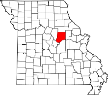 | |
| Villages | ||
| Townships | ||
| Unincorporated communities | ||
| Ghost towns | ||
| Footnotes | ‡This populated place also has portions in an adjacent county or counties | |
Municipalities and communities of Cole County, Missouri, United States | ||
|---|---|---|
| Cities |  | |
| Villages | ||
| Townships | ||
| Unincorporated communities | ||
| Ghost towns | ||
| Footnotes | ‡This populated place also has portions in an adjacent county or counties | |