Monroe, Massachusetts
| Monroe, Massachusetts | ||
|---|---|---|
| Town | ||
|
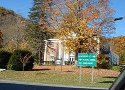
Monroe Town Hall | ||
| ||
 Location in Franklin County in Massachusetts | ||
| Coordinates: 42°43′19″N 72°56′29″W / 42.72194°N 72.94139°WCoordinates: 42°43′19″N 72°56′29″W / 42.72194°N 72.94139°W | ||
| Country | United States | |
| State | Massachusetts | |
| County | Franklin | |
| Settled | 1800 | |
| Incorporated | 1822 | |
| Government | ||
| • Type | Open town meeting | |
| Area | ||
| • Total | 10.8 sq mi (27.9 km2) | |
| • Land | 10.7 sq mi (27.7 km2) | |
| • Water | 0.08 sq mi (0.2 km2) | |
| Population (2010) | ||
| • Total | 121 | |
| • Density | 11/sq mi (4.3/km2) | |
| Time zone | Eastern (UTC-5) | |
| • Summer (DST) | Eastern (UTC-4) | |
| ZIP code | 01350 | |
| Area code(s) | 413 | |
| FIPS code | 25-42040 | |
| GNIS feature ID | 0618170 | |

Monroe is a town in Franklin County, Massachusetts, United States. The population was 121 at the 2010 census.[1] By area, population and population density, it is the smallest town in the county; and is the second-smallest town by population in the Commonwealth, with only Gosnold having fewer residents.
Monroe is part of the Springfield, Massachusetts Metropolitan Statistical Area.
History
Monroe was first settled in 1800 and was officially incorporated in 1822. The town was named for President James Monroe, who was in office at the time of incorporation. The town was mostly rural, with dairy farming taking up much of the town's economic activity. During the mid-19th century, the town did get some business from the building of the Hoosac Tunnel, just south of town in Florida. In 1885, however, a railroad line was built between neighboring Readsboro, Vermont, and Holyoke to haul wood pulp to a paper factory. This, in turn, enticed the Ramage family to establish the James Ramage Paper Company in 1887. The company was the main industry well into the 20th century, before closing in 1984.[2]
Geography
According to the United States Census Bureau, the town has a total area of 10.8 square miles (28 km2), of which 10.7 square miles (28 km2) is land and 0.1 square miles (0.26 km2), or 0.65%, is water. Monroe is located at 42° 43'18.80"N, 72° 56'29.38"W. The town is located on the northwestern corner of Franklin County along the Vermont state border, and is bordered by Berkshire County to the west and Bennington County, Vermont, to the north. It is bordered on the north by the towns of Stamford and Readsboro, Vermont, on the east by Rowe, and on the south and west by Florida. Monroe is 26 miles (42 km) northwest of Greenfield, 55 miles (89 km) north-northwest of Springfield, and 115 miles (185 km) west-northwest of Boston.
Monroe is located on the Hoosac Range, the northern end of The Berkshires. The town's border with Rowe lies along the Deerfield River, which enters the state at this point, heading south and eastward towards the Connecticut River. The river is dammed for part of this length as the southern end of the Sherman Reservoir, which formerly supplied power to the Yankee Rowe Nuclear Power Station. There are also several brooks which run through town. Much of the central and southern part of town is covered by Monroe State Forest, which extends into neighboring Florida.
Monroe is one of a handful of towns in the state without any state highways (half of these are on Martha's Vineyard and Nantucket). The nearest state highway is Massachusetts Route 2, also known as the Mohawk Trail, which runs through the neighboring towns. The nearest expressway is Interstate 91, which runs along the Connecticut River, 28 miles (45 km) east of town. The nearest regional rail, bus, and air service can be found in North Adams, and the nearest national air service is at Albany International Airport in New York.
Demographics
| Historical population | ||
|---|---|---|
| Year | Pop. | ±% |
| 1840 | 260 | — |
| 1850 | 254 | −2.3% |
| 1860 | 236 | −7.1% |
| 1870 | 201 | −14.8% |
| 1880 | 166 | −17.4% |
| 1890 | 282 | +69.9% |
| 1900 | 305 | +8.2% |
| 1910 | 246 | −19.3% |
| 1920 | 173 | −29.7% |
| 1930 | 218 | +26.0% |
| 1940 | 207 | −5.0% |
| 1950 | 174 | −15.9% |
| 1960 | 210 | +20.7% |
| 1970 | 216 | +2.9% |
| 1980 | 179 | −17.1% |
| 1990 | 115 | −35.8% |
| 2000 | 93 | −19.1% |
| 2010 | 121 | +30.1% |
Source: United States Census records and Population Estimates Program data.[3][4][5][6][7][8][9][10][11][12] | ||
Monroe is the smallest town by population and population density in Franklin County, and second smallest in Massachusetts. As of the census[13] of 2000, there were 93 people, 43 households, and 23 families residing in the town. The population density was 8.7 people per square mile (3.4/km²). There were 67 housing units at an average density of 6.3 per square mile (2.4/km²). The racial makeup of the town was 100.00% White.
There were 43 households out of which 32.6% had children under the age of 18 living with them, 27.9% were married couples living together, 16.3% had a female householder with no husband present, and 44.2% were non-families. Of all households 37.2% were made up of individuals and 14.0% had someone living alone who was 65 years of age or older. The average household size was 2.16 and the average family size was 2.83.
In the town the population was spread out with 24.7% under the age of 18, 8.6% from 18 to 24, 23.7% from 25 to 44, 25.8% from 45 to 64, and 17.2% who were 65 years of age or older. The median age was 41 years. For every 100 females there were 86.0 males. For every 100 females age 18 and over, there were 79.5 males.
The median income for a household in the town was $25,500, and the median income for a family was $21,250. Males had a median income of $23,750 versus $28,125 for females. The per capita income for the town was $12,400. There were 37.5% of families and 21.8% of the population living below the poverty line, including 30.8% of under eighteens and 26.7% of those over 64. It has the lowest per capita income for any town in Massachusetts.
Government
Monroe employs the open town meeting form of government, and is led by a board of selectmen. The town has no police station, being patrolled by the Massachusetts State Police (Shelburne Falls barracks). There is a fire station, a library connected to the regional library network, and a post office. The nearest hospital, North Adams Regional Hospital, is located in North Adams.
On the state level, Monroe is represented in the Massachusetts House of Representatives as part of the Second Berkshire district, represented by Paul Mark, which covers central Berkshire County, as well as portions of Hampshire and Franklin Counties. In the Massachusetts Senate, the town is part of the Berkshire, Hampshire and Franklin district, represented by Ben Downing, which includes all of Berkshire County and the western portions of Hampshire and Franklin Counties.[14] The town is patrolled by the Second (Shelburne Falls) Station of Troop "B" of the Massachusetts State Police.[15]
On the national level, Monroe is represented in the United States House of Representatives as part of Massachusetts's 1st congressional district, and has been represented by Richard Neal of Springfield since January 2013. Massachusetts is represented in the United States Senate by senior senator Elizabeth Warren and junior senator Ed Markey.
Education
Monroe does not have its own schools. Students attend the Abbott Memorial School in Florida between pre-kindergarten and eighth grades, and Drury High School in North Adams for ninth through twelfth grades. Students also have the option of attending C.H. McCann Technical School for high school, as well as the private and religious schools in the North Adams area for all grades.
The nearest community college, Greenfield Community College, is located in Greenfield. The nearest state college is Massachusetts College of Liberal Arts in North Adams, and the nearest state university is the University of Massachusetts Amherst. The nearest private college is Williams College in Williamstown.
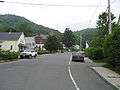 On Depot St. looking west towards town hall
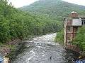 Monroe on the right (west bank), Rowe on the left (east) bank
 At the state line
 Monroe Bridge
References
- ↑ "Profile of General Population and Housing Characteristics: 2010 Demographic Profile Data (DP-1): Monroe town, Franklin County, Massachusetts". U.S. Census Bureau, American Factfinder. Retrieved August 28, 2012.
- ↑ Town History from Franklin County website
- ↑ "TOTAL POPULATION (P1), 2010 Census Summary File 1". American FactFinder, All County Subdivisions within Massachusetts. United States Census Bureau. 2010.
- ↑ "Massachusetts by Place and County Subdivision - GCT-T1. Population Estimates". United States Census Bureau. Retrieved July 12, 2011.
- ↑ "1990 Census of Population, General Population Characteristics: Massachusetts" (PDF). US Census Bureau. December 1990. Table 76: General Characteristics of Persons, Households, and Families: 1990. 1990 CP-1-23. Retrieved July 12, 2011.
- ↑ "1980 Census of the Population, Number of Inhabitants: Massachusetts" (PDF). US Census Bureau. December 1981. Table 4. Populations of County Subdivisions: 1960 to 1980. PC80-1-A23. Retrieved July 12, 2011.
- ↑ "1950 Census of Population" (PDF). Bureau of the Census. 1952. Section 6, Pages 21-10 and 21-11, Massachusetts Table 6. Population of Counties by Minor Civil Divisions: 1930 to 1950. Retrieved July 12, 2011.
- ↑ "1920 Census of Population" (PDF). Bureau of the Census. Number of Inhabitants, by Counties and Minor Civil Divisions. Pages 21-5 through 21-7. Massachusetts Table 2. Population of Counties by Minor Civil Divisions: 1920, 1910, and 1920. Retrieved July 12, 2011.
- ↑ "1890 Census of the Population" (PDF). Department of the Interior, Census Office. Pages 179 through 182. Massachusetts Table 5. Population of States and Territories by Minor Civil Divisions: 1880 and 1890. Retrieved July 12, 2011.
- ↑ "1870 Census of the Population" (PDF). Department of the Interior, Census Office. 1872. Pages 217 through 220. Table IX. Population of Minor Civil Divisions, &c. Massachusetts. Retrieved July 12, 2011.
- ↑ "1860 Census" (PDF). Department of the Interior, Census Office. 1864. Pages 220 through 226. State of Massachusetts Table No. 3. Populations of Cities, Towns, &c. Retrieved July 12, 2011.
- ↑ "1850 Census" (PDF). Department of the Interior, Census Office. 1854. Pages 338 through 393. Populations of Cities, Towns, &c. Retrieved July 12, 2011.
- ↑ "American FactFinder". United States Census Bureau. Retrieved 2008-01-31.
- ↑ List of Massachusetts Legislators by City and Town
- ↑ Station B-2, SP Shelburne Falls
External links
-
 Media related to Monroe, Massachusetts at Wikimedia Commons
Municipalities and communities of Franklin County, Massachusetts, United States | ||
|---|---|---|
| City |  | |
| Towns | ||
| CDPs | ||
| Other villages | ||
| Former inhabited places | ||