Monroe Township, Fremont County, Iowa
| Monroe Township | |
|---|---|
| Township | |
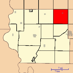 Location in Fremont County | |
| Coordinates: 40°51′29″N 95°26′31″W / 40.85806°N 95.44194°WCoordinates: 40°51′29″N 95°26′31″W / 40.85806°N 95.44194°W | |
| Country | United States |
| State | Iowa |
| County | Fremont |
| Area | |
| • Total | 35.92 sq mi (93.03 km2) |
| • Land | 35.92 sq mi (93.03 km2) |
| • Water | 0 sq mi (0 km2) 0% |
| Elevation | 1,112 ft (339 m) |
| Population (2010)[1] | |
| • Total | 230 |
| • Density | 6.4/sq mi (2.5/km2) |
| Time zone | CST (UTC-6) |
| • Summer (DST) | CDT (UTC-5) |
| ZIP codes | 51639, 51645, 51649 |
| GNIS feature ID | 0468393[2] |
Monroe Township is one of thirteen townships in Fremont County, Iowa, United States. As of the 2010 census, its population was 230 and it contained 99 housing units.[1]
History
Monroe Township was organized in 1855.[3]
Geography
As of the 2010 census, Monroe Township covered an area of 35.92 square miles (93.0 km2), all land.[1]
Cities, towns, villages
Cemeteries
The township contains Monroe Cemetery[4] and Mount Calvary Cemetery.[5]
Transportation
School districts
- Farragut Community School District
- Fremont-Mills Community School District
- Shenandoah Community School District
Political districts
- Iowa's 3rd congressional district
- State House District 23
- State Senate District 12
References
- "TIGER/Line Shapefiles". United States Census Bureau.
- 1 2 3 "2010 Census Gazetteer". United States Census Bureau. Retrieved 2014-02-23.
- ↑ "Monroe Township, Fremont County, Iowa". Geographic Names Information System. United States Geological Survey. Retrieved 2014-02-23.
- ↑ History of Fremont County, Iowa: Containing a History of the County, Its Cities, Towns, Etc. Iowa Historical Company. 1881. p. 558.
- ↑ "Monroe Cemetery". Geographic Names Information System. United States Geological Survey. Retrieved 2014-02-23.
- ↑ "Mount Calvary Cemetery". Geographic Names Information System. United States Geological Survey. Retrieved 2014-02-23.
External links
 |
White Cloud Township, Mills County | Deer Creek Township, Mills County | West Township, Montgomery County | |
| Riverside Township | |
Pierce Township, Page County | ||
| ||||
| | ||||
| Prairie Township | Walnut Township | Grant Township, Page County |
Municipalities and communities of Fremont County, Iowa, United States | ||
|---|---|---|
| Cities | ||
| Townships | ||
| CDPs | ||
| Other unincorporated community | ||
| Footnotes | ‡This populated place also has portions in an adjacent county or counties | |
This article is issued from Wikipedia - version of the 10/16/2016. The text is available under the Creative Commons Attribution/Share Alike but additional terms may apply for the media files.