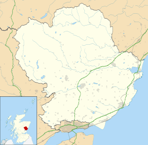
Montrose, Angus
| Montrose | |
| Scottish Gaelic: Monadh Rois | |
| Scots: Montrose | |
 |
|
 Montrose |
|
| Population | 11,955 (2011 Census) |
|---|---|
| OS grid reference | NO715575 |
| – Edinburgh | 59 mi (95 km) |
| – London | 371 mi (597 km) |
| Council area | Angus |
| Lieutenancy area | Angus |
| Country | Scotland |
| Sovereign state | United Kingdom |
| Post town | MONTROSE |
| Postcode district | DD10 |
| Dialling code | 01674 |
| Police | Scottish |
| Fire | Scottish |
| Ambulance | Scottish |
| EU Parliament | Scotland |
| UK Parliament | Angus |
| Scottish Parliament | Angus North and Mearns |
Coordinates: 56°42′29″N 2°28′01″W / 56.708°N 2.467°W
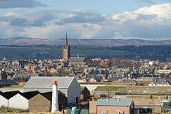
Montrose (/mɒnˈtroʊz/ mon-TROHZ, Scottish Gaelic: Monadh Rois) is a coastal resort town and former royal burgh in Angus, Scotland. It is situated 38 miles (61 kilometres) north of Dundee between the mouths of the North and South Esk rivers. It is the northernmost coastal town in Angus and developed at a natural harbour that traded in skins, hides and cured salmon in medieval times.
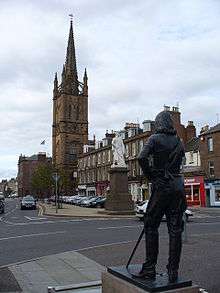
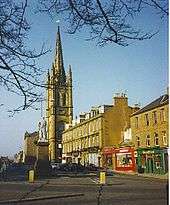
With a population of approximately 12,000, the town functions as a port, but the major employer is GlaxoSmithKline, which was saved from closure in 2006.[1] The skyline of Montrose is dominated by the 220-foot (67 m) steeple, designed by James Gillespie Graham and built between 1832 and 1834.
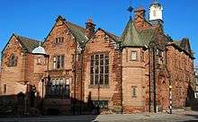
Montrose is a town with a wealth of architecture, and is a centre for international trade. It is an important commercial port for the thriving oil and gas industry. It is known for its wide thoroughfare and high street[2] which leads to picturesque closes containing secluded gardens. The town has a view of a 2 mi (3 km) square tidal lagoon, Montrose Basin, which is considered a nature reserve of international importance. It is the largest inland salt water basin in the UK, and an important habitat for the mute swan. Just outside Montrose is the 18th-century House of Dun, designed by the Scottish architect William Adam and built in 1730 for David Erskine, 13th Laird of Dun.
History
Toponymy and early history
Prehistoric elements are found in the vicinity of Montrose, including the Stone of Morphie located to the north.[3] One ancient name for Montrose was Celurca.[4] Early place names appear to show the presence of a Norse settlement in the area of the present harbour. The Norse settlement was named Stroma which translates as 'Tide race river', referring to the speed of the tidal emptying and filling of the aforementioned basin, (est 9 knots). It is claimed that the name Montrose stems from 'Mouth Hrossay' due to the location at the outlets of the River Esk near Rossie Island (Norse: horse island). However the etymology is more often attributed to the gaelic words Monadh (meaning moor) and Rois or Ros (meaning peninsula or promontory). The first documentary evidence of the existence of Montrose is the burgh charter issued by David I who founded the town around 1140 as Sallorch or Sallork.[5] By 1178 the name had taken the form Munross before becoming Montrose.[6] Folk etymology attributes the origin of the town's name as "Mount of Roses". This is reflected by the motto on the town's seal: Marie ditat, rosa decorat.[7]
Medieval history
Montrose was visited and plundered in numerous instances by Danes. In the year 980 it was sacked and razed to the ground.[8] It was once believed that a castle existed in Montrose in the 10th century and was destroyed by Kenneth III. However the historicity of this account has been disputed.[9]
In the two proceeding centuries there are no precise dates in its history. During the 1140s it was an important trading town. The trading revenues received from Montrose as well as Forfar and Dundee were acquired by Malcolm IV and contributed to Restenneth Priory.[9] In 1178 William the Lion built a castle nearby in which he would occasionally reside. The ruins have acquired the name Red Castle. The last record of a charter there was in 1198.[10] A convent dedicated to the Virgin Mary is said to have been founded in 1230 by Alan Durward but the precise location is unknown.[9] In 1244 the town succumbed to fire.[10]
In July 1296[11] during the Wars of Independence, Edward I visited the town with 30,000 of his men and stayed at Munros castle for three nights. Some accounts state that it was there that he humiliated Scottish King John de Balliol by publicly stripping him of his royal insignia and status; other accounts claim that this occurred in Brechin.[9] Twelve burgesses of the town swore allegiance to Edward I[10] to protect themselves and the community of the town.[9] The following year the castle, which was manned by an English garrison, was destroyed by William Wallace who is said to have slain all soldiers in sight.[10] The site of the castle, known as Castlestead, is at the southern end of the High Street. David II visited it towards the end of his reign in 1371.[9] The Dukedom of Montrose was created in 1488.
During the 15th century the inhabitants of the town found themselves increasingly under heel of the Lairds of Dun who ransacked and took possession of property and cattle. The lairds are said to have arrived in the middle of one night on horseback heavily armed. The burghesses of the town immediately sent out an appeal to the Duke of Montrose for protection but the messenger was purportedly murdered before the appeal arrived. It was then that James IV of Scotland intervened and settled the matter.[10]
Modern history
From its early inception as a port Montrose had traded in skins, hides and cured salmon but in the 17th century began to export wheat and barley in regular trading transactions with the Hanseatic League. The town imported flax and timber from the Baltic; salt, fruit and wine from France and Portugal.[5] The wealth this brought to the town is demonstrated in the surviving houses built by landowning and merchant families as well as local street names of "America Street", "California Street", "Baltic Street" and "India Street" evidencing its trading heritage.
The site of the castle, now known as Castlestead was the birthplace of the famous James Graham, 1st Marquess of Montrose. Graham signed the National Covenant against Charles I's reorganisation of the Kirk in Scotland, fighting in the ensuing Bishops' Wars, but later switched to the King's side only to be captured and executed in Edinburgh in the year 1650.
The final chapter of the ill-fated 1715 Jacobite rebellion was also played out in Montrose. Towards the end of the uprising (which had lasted nearly six months, from September 1715 to February 1716) James Francis Edward Stuart (the Old Pretender; formerly James, Prince of Wales) arrived in Montrose, where he spent his last night in Scotland, on 4 February 1716. He sailed from Montrose to exile in France. The town was held for his son, Charles Edward Stuart (Bonnie Prince Charlie; the Young Pretender), 30 years later and in February 1746 the largest naval battle of the war was fought in Montrose Harbour.
During the 18th century the town was a major smuggling centre. It profited from the slave trade but only for a brief time. The wealth accrued by trade was substantial. Wealthy merchants in the 18th and 19th centuries dominated the town and built their houses gable to gable. Hence Montrosians have inherited the sobriquet, "gable-enders".[12] A statistical account taken between 1791 and 1799 estimates the population in the 1750s as 4248; in 1776 as 4465; in 1784 as 4866 and in 1790 as 5194. Contemporaries expected that many would emigrate at the conclusion of the American Revolutionary War but those that did leave were few.[13]
Samuel Johnson made a tour of the town on his visit to Scotland in the 1770s. He said of it:
"...we travelled on to Montrose, which we surveyed in the morning and found it well-built, airy, and clean. The town house is a handsome fabrick with a portico. We then went to view the English chapel, and found it a small church, clean to a degree unknown in any other part of Scotland, with commodious galleries, and what was yet less expected, with an organ.".[14]
Alexander Christie (c. 1721-1794) was provost in the town during the 1760s and 1780s and oversaw the establishment of Scotland's first Lunatic Asylum in Montrose in 1781[15] which became Sunnyside Royal Hospital.
In 1785 a subscription library for learned men was formed.[16]

Before World War I the Royal Flying Corps established a base at Montrose (later RAF Montrose). On 26 February 1913, it became the first operational military aerodrome to be established in the United Kingdom.[17]
During World War II Montrose became a hub for a constant stream of international pilots from all over the Commonwealth, Poland, Czechoslovakia, America, Russia, France and other allied nations. As well as a training base Montrose was also an operational airfield for Hawker Hurricane and Supermarine Spitfire squadrons, which flew sorties over Norway and were a part of the air defences for Edinburgh. Of course, this also made the town a target for German aircraft and it was bombed on more than one occasion. Despite its coastal location presenting a danger however, large numbers of children and young mothers from Dundee were evacuated there during the period of the Phoney War. Initially numbers totalled around 2,000 but in a second wave around 1,200 more were sent.[18] As was the case in many other receiving areas, the local population was concerned by the condition of the urban poor and impetigo and vermin were found on some of those evacuated. By June 1940 Montrose could no longer provide shelter.[18]
Montrose was a royal burgh until 1975.[19]
Bamse
Bamse (meaning teddybear in Norwegian), famed for his exploits and popular in local imagination, is buried in the town. Bamse the Norwegian Sea Dog arrived in Montrose on the Royal Norwegian Navy minesweeper Thorodd during World War II with Captain Erling Hafto, his owner, who registered him as a crew member. He saved the life of Lieutenant Commander Olav Nilsen at Dundee Docks and generally protected his fellow sailors. In stories Bamse is said to have got up on his hind legs and, at over 6 feet (1.8 m) tall, clamped his great paws on assailants to end any fight. On his death in July 1944 Montrose schools were closed and 800 children lined the route to his graveside funeral.
The Bamse Project raised £50,000 to erect a larger than life-size bronze statue of Bamse at Montrose Harbour. Half the donations came from Norway. The statue was created by internationally known sculptor Alan Herriot, and was unveiled by The Duke of York in October 2007.
Governance
Montrose is represented within Angus Council by the Montrose & District Ward, from which four councillors are elected. The members elected from this ward are, as of 2012: Bill Duff (Scottish National Party), Mark Salmond (Independent), Paul Valentine (Scottish National Party) and David May (Scottish Liberal Democrats).[20]
The town is part of the Angus constituency of the Parliament of the United Kingdom which returns a Member of Parliament (MP) to the House of Commons, at Westminster. The constituency's MP is currently Mike Weir of the Scottish National Party.[21]
Montrose is also part of the Angus constituency of the Scottish Parliament, which has significantly different boundaries to the Westminster constituency. The constituency returns a Member of the Scottish Parliament (MSP) to Holyrood directly, and is part of the North East Scotland electoral region with regards to additional Members of the Scottish Parliament. The constituency's MSP is currently Andrew Welsh of the Scottish National Party.[22] For the 2011 Scottish Parliament election, the constituency of Angus is due to be split into two separate constituencies and Montrose will become part of the newly formed Angus North and Mearns.
Geography and natural features
Montrose occupies a position on the North Bank of Montrose Basin at the mouth of the River South Esk on the East Coast of Scotland, 11 miles (18 km) NNE of Arbroath,[23] 19 miles (31 km) SW of Stonehaven,[23] and 7.2 miles (12 km) ESE of Brechin.[23] The town lies 62.2 miles (100 km) NNE of Edinburgh,[24] and 373.2 miles (601 km) NNW of London.[25] The built-up area occupies a roughly rectangular shape 2 miles (3 km) long by 0.75 miles (1 km) wide, aligned in a North-South orientation. The land is relatively flat, rising gradually to around 15m elevation to the North of the town.[23]
The expanse of the town extends to the villages on its fringes; Hillside and Ferryden. It lies close to the hamlets of Lunan and St Cyrus. The rural location ensures that the air quality is good, with low levels of nitrogen dioxide and PM10.[26]
Montrose Basin
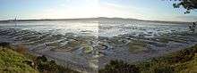
The Montrose Basin is a shallow estuary approximately three miles in diameter.[27] It is situated where the River South Esk meets the North Sea. During the 16th century, local landowners desiring more arable land considered reducing its size, but their plans were never carried out.[28]
In 1981 the Montrose Basin Nature Reserve was created.[29] The Scottish Wildlife Trust operates a modern, purpose-built wildlife centre at Rossie Braes, which offers good telescopic and televisual views of the area, and of the thousands of migratory birds which pass through the area in all seasons.
In summer, one might see the osprey which hunts along the length of the Basin, or a kingfisher flitting past. The artificial sand-martin bank is a hive of activity all spring and early summer. One can watch the blue tits and swallows inside their nests, and take in the panoramic vista of the rolling Angus countryside and hills.
In October and November there are 38,000 birds using the basin.[29] In winter, 20,000 pink-foot geese take up residence on the mudflats, feeding in the nearby fields by day, and returning to the safety of the Basin in the evening. The haunting fluting of their calls are beloved of local people, for whom the sound marks the turning of the seasons. The many feeders attract brightly coloured field and garden birds, and the occasional woodpecker.
In recent years research published by Scottish Natural Heritage claimed that the population of greylag geese has fallen as a result of climate change.[30]
Montrose Beach
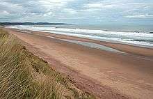
The 3-mile-long (4.8 km) sandy beach has been awarded a Blue Flag for its eco credentials.[31] The surrounding Traill Pavilion and Seafront Splash! facilities with an arcade, a playground, a café and an ice-cream stall is popular amongst locals and visitors alike. North of the town the River North Esk enters the North Sea across the beach.
The Save our Sands Campaign (SOS) was set up on 26 March 2009[32] to raise awareness amidst concerns over the erosion of Montrose beach, caused by the "one million tonnes of sand, swept by the tide into the harbour...removed from the local area over the past 25 years".[33] In 2006 150,000 tonnes was shipped to Aberdeen to fortify its dwindling beach. This was met with opposition from Montrose Golf Links who believed that the golf course built on top of the dunes, as one of the oldest in the world, should be protected.[34] The sand dunes are becoming unstable due to increasing tides which has forced the Montrose Golf Links to consider moving the golf course more inland. However Scottish Natural Heritage opposes the realignment as it could affect a protected coastal site at St Cyrus.[35]
A film made by local broadcaster Anthony Baxter in January 2009 highlighted the issue and was designed to attract attention for urgent action and put pressure on local politicians. The group are concerned that Angus Council are not acting efficiently to halt the effects of erosion and believe a full study should be carried out. The film won the best short film category in the BFFS Community Cinema Festival in 2009. Since 2009 a team from the University of Dundee has begun assessing the coastline around Montrose in a two-year study to decide the best way of managing coastal erosion.[33] The film titled "SOS Montrose Dredging" has been posted on YouTube.[36]
Demography
The 2001 census gave Montrose's total resident population as 10,845. This makes it the third largest town in Angus, after Arbroath (22,785) and Forfar (14,048) with Carnoustie in fourth place (10,561).[37]
Since the Second World War the population of Montrose has increased. The presence of Dundee families in Montrose during wartime convinced a number to settle there.[18] This altered the demographics of the town and led to the building of housing estates in the 1960s. A number of people from the Polish community who had served with the British forces at RAF Montrose also settled.
There is an increasing elderly population which is reflected in the profusion of nursing and residential homes and in recent plans to extend provision for sheltered housing.[38] Data published by Scottish Neighbourhood Statistics in 2008 records the population of Montrose & District as 15,013 which is around 18% of the population of Angus as a whole. Of this total 17.6% are children, 60% are of working age and 22% are pensioners. Around 12% of those who live in the town are unemployed and 14.1% of households are "income deprived".[39]
| Historic population of Montrose, Angus[nb 1] | |||||||||||
| Year | 1801 | 1811 | 1821 | 1831 | 1841 | 1851 | 1861 | 1871 | 1881 | 1891 | 1901 |
|---|---|---|---|---|---|---|---|---|---|---|---|
| Population | 7,975 | 8,955 | 10,338 | 12,055 | 13,402 | 14,328 | 14,563 | 14,548 | 14,973 | 12,883 | 12,427 |
| Year | 1911 | 1921 | 1931 | 1941 | 1951 | 1961 | 1971 | 1981 | 1991 | 2001 | 2011 |
| Population | 10,974 | 10,979 | 10,196 | [nb 2] | 10,762 | - | 10,063 | 11,214 | 11,467 | 10,845 | 11,955 |
Education
Schools include six primary schools, Lochside, Ferryden, Southesk, Rosemount, Borrowfield and St Margarets, and one secondary school Montrose Academy.
Economy
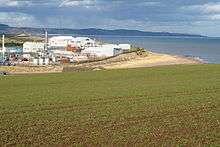
The economy of the town has been expanding since the end of the Second World War. GlaxoSmithKline has been a major source of jobs since the 1950s.[43] Other significant employers include Tesco, Co Operative Group, Petrofac, National Oilwell Varco and Argos. The Lochside Distillery, located on Brechin Road north of the town centre, was closed down in the 1990s and the buildings demonlished in 2005 after a fire. In 2009 Sainsbury's announced plans to build a new superstore on the edge of the town which will provide work for an estimated 200 people. Construction of the new Sainsburys store was approved by Angus Council in August 2011 and spokespersons from Sainsburys believe the store will open in less than a year and provide at least 200 full and part-time jobs for local people. BT recently upgraded the local telephone exchange to grant the town access to super fast fiberoptic broadband services one of only three towns to be chosen in Scotland.[44] The average price of housing in the town is between £106,054 and £131,539,[45] a rise on the 1998 average between £42,640 and £51,200.[46]
Tourism
Since 2002 there has been a focus on attracting new visitors to the town with the foundation of the Montrose Town Partnership which aims to "encourage representatives of the public, private and community sector to act together to develop the economic potential of Montrose to address the needs of local people and visitors alike".[47] Membership includes The Montrose Society, Montrose Heritage Trust, Montrose Community Council, Montrose Golf Links Ltd, MERPRO Leisure, Montrose Business and Retailers Association, Scottish Wildlife Trust, Angus Council, Ferryden & Craig and Hillside, Dun and Logie Pert community councils.[47] Since 2002 they have produced a number of promotional leaflets and have established a weekly Saturday market in the town centre.[48] In 2002 plans were unveiled to renovate the Mid Links.[49] The project was completed in 2003 at the total cost of £1.8million with £1.2million granted by the Heritage Lottery Fund.[50] Plaques have been incorporated to inform visitors of the historical heritage of the town's buildings.
Culture
Cultural history
Montrose is regarded as the culture and sculpture capital of Angus,[51] with over 20 statues of note scattered around the town. The statues are a mix of contemporary and classical works, with many from the noted local sculptor, William Lamb ARSA. Lamb was born in Montrose in 1893 and was an artist of exceptional talent.
In Montrose from the 1920s to 1940s, local architect George Fairweather’s studio provided a forum for lively debate by an artistic community that included Hugh MacDiarmid, Edwin Muir, William Lamb, Helen Cruickshank and Fionn MacColla. The local weekly newspaper, the Montrose Review, was edited by Hugh MacDiarmid.
Music
Since 2008, Montrose has hosted the Montrose Music Festival or Mo Fest as its affectionately become known, which takes place each year at the end of May. It has grown in size and stature each year to become Scotland's biggest free live music festival with over 200 free gigs played over the three days in over 26 venues across the town, including an open air stage on Montrose's historic High street with the dominating Montrose Steeple behind the stage which draws crowds of all ages from all over the country. In 2014 the MoFest team took a leap and hosted a gig on Montrose East Links to 5000 revelers on the Friday night which kicked off the 7th annual festival with rock legends Status Quo playing to the sell out crowd. Other Notable Headliners who have played at the festival include Average White Band, Deacon Blue, The Proclaimers, Ocean Colour Scene, Toploader, Eddi Reader & Madness.
Sport
Montrose also has the 5th oldest golf course in the world, the Montrose Medal, dating from 1562. It is also a qualifying course for The Open Championship. Past events hosted on the Montrose Links include:
- Scottish Professional Championship, 1909, 1967, 1970
- Scottish Amateur Championship, 1905, 1913, 1919, 1926 and 1925
- British Boys Championship, 1991; Scottish Universities Championship
- Final Qualifying for The Open, 1999 and 2007.
Montrose F.C. are members of the Scottish Football League and currently play in League Two. Montrose Roselea F.C. are a Scottish junior football, Formed in 1930 and nicknamed "the Lea", they play their home games at Broomfield Park. Other sports associations include the Montrose Cricket Club, Montrose Tennis Club, Montrose & District SEALS Swimming Club, Montrose & District Athletics, Rugby union club, Montrose Sailing Club (dinghy sailing on the Basin) and several bowls clubs which are part of the Montrose & District Bowling Club Association.
Religious sites
Christian groups
There are many churches in Montrose. Three belong to the Church of Scotland: Montrose Old and St Andrew's ('Auld Kirk'), Melville-South Parish Church, Dun and Hillside Church. There are two United Free Churches: Knox's Church and Ferryden Church. Grace Church Montrose is a new church plant belonging to the Free Church of Scotland.[52][53] In the Links there is an Episcopal Church (St Mary's and St Peter's) the United Reformed Church and Methodist Church nearby. In Borrowfield there is a Baptist Church and LDS Church. A Quaker group meets in the town. The Roman Catholic community is served by St Margaret's Roman Catholic Church.
The most prominent church is the Old and St Andrew's Church, Montrose. Reverend Dr Charles Nisbet who became minister in 1764 described it as a church which "embraced much cultivation and intelligence".[54]
A Kingdom Hall of Jehovah's Witnesses lies on the edge of the town.
Public services
Montrose and the surrounding area is supplied with water by Scottish Water from the Lintrathen and Backwater reservoirs in Glen Isla. Electricity distribution is by Scottish Hydro Electric plc, part of the Scottish and Southern Energy group.
Waste management is handled by Angus Council. There is a kerbside recycling scheme that has been in operation since March 2005. Cans, glass, paper and plastic bottles are collected on a weekly basis. Compostable material and non-recyclable material are collected on alternate weeks.[55] Roughly two thirds of non-recyclable material is sent to landfill at Angus Council's site at Lochhead, Forfar and the remainder sent for incineration (with energy recovery) outside the council area.[56]
A recycling centre is located at Broomfield Road. Items accepted include, steel and aluminium cans, cardboard, paper, electrical equipment, engine oil, fridges and freezers, garden waste, gas bottles, glass, liquid food and drinks cartons, plastic bottles, plastic carrier bags, rubble, scrap metal, shoes and handbags, spectacles, textiles, tin foil, wood and yellow pages. Angus council publishes details of where and how each product is processed.[57] There are also glass banks at Tesco in Western Road and Scotmid in New Wynd, as well as a neighbourhood recycling point at Wharf Street.[58] The Angus Council area had a recycling rate of 34.7% in 2007/08.[55]
Healthcare is supplied in the area by NHS Tayside. The nearest hospitals with accident and emergency departments is Ninewells Hospital, Dundee. Primary Health Care in Montrose is supplied by Castlegait Surgery, Townhead Practice and Annatbank Practice which are based at the Links Health Centre. Montrose along with the rest of Scotland is served by the Scottish Ambulance Service.[59]
Law enforcement is provided by Police Scotland,[60] and Montrose is served by Tayside Fire and Rescue Service.[61]
Notable connections
- Edward Baird was born in Montrose in 1904 and studied at Glasgow School of Art from 1924 to 1927. Baird returned to Montrose after graduating and lived there for the rest of his life, painting local subjects and keeping a low profile. Often described as a Scottish Surrealist, Baird is equally known for his association with the Scottish Renaissance movement. His artistic output was relatively small, due to his perfectionism, time-intensive manner of working and his early death at the age of forty-five.
- Pioneering botanist, Robert Brown, the discoverer of the cell nucleus, of cytoplasmic streaming and of Brownian motion was born in Montrose.
- Captain Sir Alexander Burnes, Explorer.
- David Carnegie (entrepreneur)
- George Paul Chalmers, Artist - The Angus Rembrandt.
- Helen Cruickshank, the Scottish poet,[62] grew up in this area.
- Henry Renny-Tailyour, an amateur all-round sportsman who appeared for Scotland in some of the earliest international football and rugby union matches, also played first class cricket for Kent and was an accomplished athlete. He is also the first person to score a goal for Scotland in an international match.
- Malcolm Duncan (musician), Saxophone player with the Average White Band
- James Graham, 1st Marquis of Montrose, a Scottish nobleman and soldier born in Montrose in 1612.
- Joseph Hume, Scottish doctor and politician was born in Montrose in 1777.
- Violet Jacob (1863–1946) was a Scottish writer, now known especially for her historical novel Flemington and her poetry.
- David Luckie (1827-1909) Journalist, Politician[63]
- Fionn MacColla, pen-name of Thomas Douglas MacDonald, writer associated with the Scottish Renaissance.
- Hugh MacDiarmid, was once editor of the local newspaper.
- John McGovern (footballer), Nottingham Forest European Cup winning captain.
- Andrew Melville, Radical Presbyterian who ensured the completion of Knox's Reformation in Scotland.
- Tanner Foust, an American professional racing driver, stunt driver, and television host. He has hosted such programs as Top Gear (U.S. TV series)
- James Morrison (artist) RSA, RSW, Artist
- Hercules Ross, gave evidence in support of the abolition of the slave trade.
- Horatio Ross, Sportsman, Photographer & Politician.
- Gordon Smith (footballer born 1924), footballer.
- George Wishart, Lutheran Reformer and Martyr.
- William Lamb (artist)
- Syd Walker MBE, Artist Est first studio in Montrose circa 1957 Scottish Area Representative of the Bevin Boys Association.
Twin towns
See also
- RAF Montrose
- House of Dun
- Montrose railway station
- List of Provosts of Montrose
- Montrose Air Station Heritage Centre
Notes
References
- ↑ GlaxoSmithKline Montrose Plant Reprieve
- ↑ "Montrose High Street".
- ↑ C. Michael Hogan, Stone of Morphie, 2007, Megalithic Portal, ed. Andy Burnham
- ↑ Mitchell (1866), p1
- 1 2 "The Royal Burgh of Montrose", Angus Council
- ↑ A.D Mills, A Dictionary of British Place-Names. Oxford University Press. 2003. ISBN 0-19-852758-6
- ↑ Rev. Mr. Alexander Molleson, "Town and Parish of Montrose", The Statistical Accounts of Scotland (1791-99), Vol.5, p24
- ↑ Mitchell (1866), p6
- 1 2 3 4 5 6 Andrew Jervise, "Memorials of Angus and the Mearns"
- 1 2 3 4 5 Mitchell (1866), p8
- ↑ Angus Council, "The Royal Burgh of Montrose"
- ↑ Alan Murphy, Scotland, Footprint Travel Guides. 2004, p504
- ↑ Revd Mr Alexander Molleson, "Town and Parish of Montrose", The Statistical Accounts of Scotland (1791-99), Vol.5, p32
- ↑ Samuel Johnson, The Works of Samuel Johnson (1823), p239
- ↑ Angus Council, "Provost Alexander Christie of Montrose (c 1721-1794)"
- ↑ Rev. Mr. Alexander Molleson, "Town and Parish of Montrose", The Statistical Accounts of Scotland (1791-99), Vol.5, p35
- ↑ "Montrose air station, the UK's first airfield, marks centenary". BBC News. 23 February 2013. Retrieved 23 February 2013.
- 1 2 3 Forbes Inglis, "An Invasion of Montrose", Montrose Review, 20 August 2009.
- ↑ Gazetteer of Scottish Places
- ↑ "Election 2012 Results Ward 8 – Montrose & District". Angus Council. Retrieved 8 May 2012.
- ↑ "List of MPs". UK Parliament. Retrieved 7 December 2010.
- ↑ "The Scottish Parliament: Current Members". www.scottish parliament.uk. Retrieved 7 December 2010.
- 1 2 3 4 OS Explorer 1:25000 382 (6th edition) Arbroath, Montrose & Carnoustie, Ordnance Survey, 2006
- ↑ "UK Postcode to PostCode Distance Calculator: DD10 to EH1". PostCode.org.uk. Retrieved 10 March 2011.
- ↑ "UK Postcode to PostCode Distance Calculator: DD10 to W1". PostCode.org.uk. Retrieved 10 March 2011.
- ↑ Source: Scottish Neighbourhood Statistics
- ↑ N. W. H. Allsop, Breakwaters, Coastal Structures and Coastlines, Institution of Civil Engineers, 2002, Thomas Telford publisher, 520 pages ISBN 0-7277-3042-8
- ↑ Rev. Mr. Alexander Molleson, "Town and Parish of Montrose", The Statistical Accounts of Scotland (1791-99), Vol.5, p26
- 1 2 Angus Council, "Nature Reserve Comes of Age", 20 June 2002
- ↑ "SWT dispute basin claim". Montrose Review. 31 December 2009.
- ↑ The Links Hotel. Retrieved on 27 August 2009.
- ↑ Dowie, Mark (27 March 2009). "Internet campaign aims to raise awareness of coastal erosion". Press & Journal. Retrieved 3 January 2010.
- 1 2 Dowie, Mark (31 December 2009). "National Award for Erosion Film". Montrose Review.
- ↑ "Beach sand plan may be bunkered". BBC News. 6 June 2006. Retrieved 3 January 2010.
- ↑ "Historic golf course erosion fear". BBC News. 5 April 2006. Retrieved 3 January 2010.
- ↑
- ↑ "Comparative Population Profile: Carnoustie Locality", Scotland's Census Results Online (29 April 2001), retrieved 1 September 2008
- ↑ Angus Council, "Sheltered Housing for Montrose", 6 November 2001
- ↑ Source: Scottish Neighbourhood Statistics
- ↑ "Historic Statistics". A Vision of Britain through time. Retrieved 20 April 2011.
- 1 2 "Montrose Settlement" (PDF). Angus Council Planning and Transport Department. Retrieved 20 April 2011.
- ↑ "Online Historical Population Reports". University of Essex. 2007. Retrieved 20 April 2011.
- ↑ , "Angus Council, Day Out At Seafront Splash For Pupils", 21 June 2002
- ↑ Montrose Review, 20 August 2009.
- ↑ Source: Scottish Neighbourhood Statistics 2008
- ↑ Source: Scottish Neighbourhood Statistics
- 1 2 Angus Council, "Montrose Partnership News", 13 December 2004
- ↑ Angus Council, "Montrose Town Partnership", 11 December 2001
- ↑ Angus Council, "Mid Links Restoration Plans to go on display", 6 June 2002.
- ↑ Angus Council, "Mid Links Montrose", 24 December 2003
- ↑ "Draft Amendment to the Downtown Enhancement Plan". Retrieved on 11 September 2009.
- ↑ https://theweeflea.wordpress.com/tag/grace-church-montrose/
- ↑ http://freechurch.org/news/new-congregation-in-montrose-begins-this-weekend
- ↑ Samuel Miller, "Memoir of the Rev. Charles Nisbet, D.D.: late president of Dickinson college, Carlisle", (1840).
- 1 2 "Angus Council kerbside Recycling Scheme". Angus Council. Retrieved 10 March 2011.
- ↑ "Angus Council local plan section 37" (PDF). Angus Council. Retrieved 10 March 2011.
- ↑ "Angus Council Recycling centres". Angus Council. Retrieved 10 March 2011.
- ↑ "Neighbourhood Recycling Points & Glass Banks in Angus". Angus Council. Retrieved 10 March 2011.
- ↑ "Scottish Ambulance Service". Retrieved 10 March 2011.
- ↑ "Tayside Police". Retrieved 10 March 2011.
- ↑ "Tayside Fire and Rescue Service". Retrieved 10 March 2011.
- ↑ Helen Cruickshark biography
- ↑ David Luckie
- ↑ Montrose Review, 27 August 2009
Further reading
- Norman Keir Atkinson, The Early History of Montrose, (Angus Council Cultural Services, 1997) ISBN 1-873752-30-X
- James Bowick, John Lee et al., Montrose Characters: Past and Present, (Montrose, 1881)
- Duncan Fraser, Montrose (before 1700), (Montrose: Standard Press, 1967)
- Duncan Fraser, The Smugglers, (Montrose: Standard Press, 1971)
- Gordon Jackson & S.G.E. Lythe (eds), The Port of Montrose, (Tayport: Hutton, 1993) ISBN 1-872167-51-9
- James G. Low, Industry in Montrose, (Monikie: Pitnolen Publications, 1994)
- W. A. McNeil, Montrose before 1700 from original documents, (Dundee: Abertay Historical Society, 1961)
- David Mitchell, The History of Montrose, (Montrose: Geo. Walker, 1866)
- Tom Valentine, Old Montrose, (Catrine: Stenlake, 1997)
External links
History and tourism
- Old maps of Montrose (1693–1861)
- History of Montrose by Angus Council
- Montrose Natural History and Antiquarian Society
- Montrose Air Station Heritage Centre
- Bamse Memorial Website
- Visit Montrose
- Montrose Golf Links
Photographs
- Photos of Montrose from Flickr
- More photos of Montrose from Flickr
- Photos of Montrose from The Gazetteer for Scotland
Community links
- Montrose Community Website
- Montrose Society
- Montrose Review
- Montrose Music Festival
- Old and St Andrews Church
- Sleepyhillock Cemetery
- List of men recorded on Montrose War Memorial
- Montrose Twinning Association Website