Montrose, British Columbia
| Montrose | |
|---|---|
| Village | |
| The Corporation of the Village of Montrose[1] | |
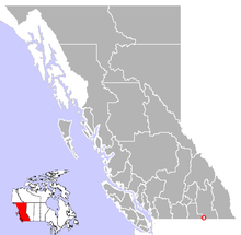 Location of Montrose in British Columbia | |
| Coordinates: 49°04′44″N 117°35′32″W / 49.07889°N 117.59222°W | |
| Country |
|
| Province |
|
| Region | West Kootenay |
| Regional district | Kootenay-Boundary |
| Incorporated | 1956 |
| Government | |
| • Governing body | Montrose Village Council |
| • Mayor | Joe Danchuk[2] |
| Area | |
| • Total | 1.52 km2 (0.59 sq mi) |
| Elevation | 580 m (1,944 ft) |
| Population (2011) | |
| • Total | 1,030[3] |
| Time zone | PST (UTC-8) |
| Highways | 3B |
| Waterways | Columbia River |
Montrose is a village located in south-eastern British Columbia in the West Kootenay region. It is located 7 km east of the city of Trail along Highway 3B.
Geography
The village of Montrose is built on a mountain ledge leading to Beaver Valley. Because of its limited physical area, there is very little fluctuation in population.
History
Originally known as "Wood's Flats," Montrose was developed as a retirement village for workers from the nearby Cominco (now Teck) smelter. It was incorporated in 1956 as a village, and is named after a popular resort destination in Scotland (Montrose, Angus). The construction of the "Montrose Cutoff," an extension of Highway 3B from Fruitvale to Trail, reduced travel time to Trail from ~45 minutes to 10 minutes, making the village more attractive to commuters.
Economy
There is a post office, an Oriental restaurant and one combined gasoline station/corner store in the village. Other than home-based businesses, virtually all other employment is based in the nearby city of Trail. Major employers of Montrose residents include Teck, the Kootenay Boundary Regional Hospital, School District 20, Ferraro Foods, and the Trail operations of such large corporations as Fortis BC, Wal-Mart, Extra Foods (Weston Corp), Canadian Tire and international engineering consultants AMEC Plc.
Montrose is known throughout the Kootenay region of BC for its excellent drinking water, a sample of which received silver medals in the 2008 and 2009 Berkeley Springs International Water Tasting Competition.
Features
Montrose is also the location of the "Antenna Trail" a 4 kilometre loop hiking trail that rises 250 metres above the village and affords spectacular views of the Beaver and Columbia Valleys. This trail is part of the Kootenay Columbia Trail system although it is not contiguous with the rest of the trails located near, and accessed from, nearby Rossland. The Antenna Trail is popular because it is snow-free much earlier in the spring than the higher elevation trails, and has little if any mountain bike traffic.
The village shares its territory with a variety of native BC wildlife. Elk, Whitetail Deer, Black Bears, and Wild Turkeys are frequently spotted on Montrose Mountain, and occasionally within the village proper. Hummingbirds are attracted by the numerous feeders put out by residents, with at least 7 different species recorded.
References
- ↑ "British Columbia Regional Districts, Municipalities, Corporate Name, Date of Incorporation and Postal Address" (XLS). British Columbia Ministry of Communities, Sport and Cultural Development. Retrieved November 2, 2014.
- ↑ Village of Montrose, West Kootenays, British Columbia: Village Council
- ↑ Village of Montrose, West Kootenays, British Columbia: Community
External links
| Subdivisions |  | |
|---|---|---|
| Communities | ||
| Metro areas and agglomerations | ||
| Villages |
| |
| ||
Coordinates: 49°4′42″N 117°35′35″W / 49.07833°N 117.59306°W