Moss Landing, California
| Moss Landing | |
|---|---|
| Census designated place | |
|
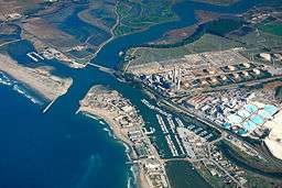
Aerial view of Moss Landing, California | |
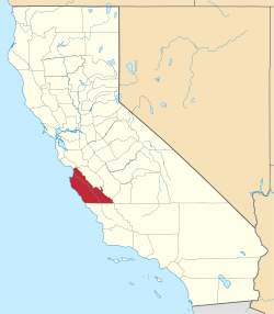
 Location in Monterey County and the state of California | |
 Moss Landing Location in the United States | |
| Coordinates: 36°48′16″N 121°47′13″W / 36.80444°N 121.78694°WCoordinates: 36°48′16″N 121°47′13″W / 36.80444°N 121.78694°W | |
| Country |
|
| State |
|
| County | Monterey |
| Government | |
| • State senator | Bill Monning (D)[1] |
| • Assemblymember | Mark Stone (D)[1] |
| • U. S. rep. | Sam Farr (D)[2] |
| Area[3] | |
| • Total | 0.603 sq mi (1.562 km2) |
| • Land | 0.398 sq mi (1.03 km2) |
| • Water | 0.205 sq mi (0.532 km2) 34.06% |
| Elevation[4] | 10 ft (3 m) |
| Population (April 1, 2010) | |
| • Total | 204 |
| • Density | 340/sq mi (130/km2) |
| Time zone | Pacific (UTC-8) |
| • Summer (DST) | PDT (UTC-7) |
| ZIP code | 95039 |
| Area code | 831 |
| FIPS code | 06-49488 |
| GNIS feature IDs | 1659184, 2408874 |
Moss Landing (formerly, Moss)[5] is a census designated place (CDP) in Monterey County, California, United States.[4] Moss Landing is located 15 miles (24 km) north-northeast of Monterey,[5] at an elevation of 10 feet (3 m).[4] It is located on the shore of Monterey Bay, at the mouth of Elkhorn Slough, and at the head of the Monterey Canyon.
History
Moss Landing was originally called Moss.[5] The Moss post office opened in 1895, and changed its name to Moss Landing in 1917.[5] The name honors Charles Moss, who with a partner, built a wharf there.[5] The port was a busy whaling port.[5]
Prior to 1981, the community suffered from grave water contamination, severe septic tank failures, and public health problems. Sanitary sewers for the entire area were installed in 1982-84 due to federal grants secured by then Monterey County Supervisor Marc Del Piero.
The earliest culture that left evidence of the Moss Landing Elkhorn Slough area was that of the Ohlone Indians. Evidence from archaeological digs show that they may have lived here as long as 4,000 years ago. The Spanish took the landscape from the Ohlone Indians when they began settling missions in the 1700s and ran cattle over the hills of the surrounding area. The Americans arrived in the mid- 1800s and farmers turned the area into cropland. Loggers stripped the hillsides of trees. Whalers put out from the shore of Moss Landing to capture migrating whales, and a processing plant onshore reduced the giant mammals to oil and whale bone. Charles Moss, full of plans and schemes for his town at the mouth of the Elkhorn Slough, built a shipping facility and a pier. This pier where all the boats landed was owned by Moss, so the area became known as Moss Landing.
Geography
Moss Landing is located at 36°48′16″N 121°47′13″W / 36.80444°N 121.78694°W.[4]
According to the United States Census Bureau, the CDP has a total area of 0.6 square miles (1.6 km2), of which, 0.4 square miles (1.0 km2) of it is land and 0.2 square miles (0.52 km2) of it (34.06%) is water.
Climate
This region experiences warm (but not hot) and dry summers, with no average monthly temperatures above 71.6 °F. According to the Köppen Climate Classification system, Moss Landing has a warm-summer Mediterranean climate, abbreviated "Csb" on climate maps.[6]
Demographics


2010
The 2010 United States Census[7] reported that Moss Landing had a population of 204. The population density was 338.3 people per square mile (130.6/km²). The racial makeup of Moss Landing was 149 (73.0%) White, 7 (3.4%) African American, 1 (0.5%) Native American, 2 (1.0%) Asian, 1 (0.5%) Pacific Islander, 30 (14.7%) from other races, and 14 (6.9%) from two or more races. Hispanic or Latino of any race were 46 persons (22.5%).
The Census reported that 204 people (100% of the population) lived in households, 0 (0%) lived in non-institutionalized group quarters, and 0 (0%) were institutionalized.
There were 100 households, out of which 21 (21.0%) had children under the age of 18 living in them, 36 (36.0%) were opposite-sex married couples living together, 11 (11.0%) had a female householder with no husband present, 4 (4.0%) had a male householder with no wife present. There were 8 (8.0%) unmarried opposite-sex partnerships, and 0 (0%) same-sex married couples or partnerships. 41 households (41.0%) were made up of individuals and 11 (11.0%) had someone living alone who was 65 years of age or older. The average household size was 2.04. There were 51 families (51.0% of all households); the average family size was 2.76.
The population was spread out with 32 people (15.7%) under the age of 18, 8 people (3.9%) aged 18 to 24, 54 people (26.5%) aged 25 to 44, 84 people (41.2%) aged 45 to 64, and 26 people (12.7%) who were 65 years of age or older. The median age was 46.5 years. For every 100 females there were 108.2 males. For every 100 females age 18 and over, there were 115.0 males.
There were 108 housing units at an average density of 179.1 per square mile (69.1/km²), of which 55 (55.0%) were owner-occupied, and 45 (45.0%) were occupied by renters. The homeowner vacancy rate was 0%; the rental vacancy rate was 8.2%. 118 people (57.8% of the population) lived in owner-occupied housing units and 86 people (42.2%) lived in rental housing units.
2000
As of the census[8] of 2000, there were 300 people, 125 households, and 68 families residing in the CDP. The population density was 734.9 people per square mile (282.5/km²). There were 135 housing units at an average density of 330.7 per square mile (127.1/km²). The racial makeup of the CDP was 59.33% White, 3.00% African American, 0.67% Native American, 2.00% Asian, 21.67% from other races, and 13.33% from two or more races. Hispanic or Latino of any race were 28.33% of the population.
There were 125 households out of which 27.2% had children under the age of 18 living with them, 39.2% were married couples living together, 14.4% had a female householder with no husband present, and 45.6% were non-families. 31.2% of all households were made up of individuals and 8.8% had someone living alone who was 65 years of age or older. The average household size was 2.40 and the average family size was 3.09.
In the CDP the population was spread out with 21.3% under the age of 18, 11.7% from 18 to 24, 34.3% from 25 to 44, 21.7% from 45 to 64, and 11.0% who were 65 years of age or older. The median age was 36 years. For every 100 females there were 117.4 males. For every 100 females age 18 and over, there were 118.5 males.
The median income for a household in the CDP was $66,442, and the median income for a family was $66,731. Males had a median income of $41,154 versus $36,691 for females. The per capita income for the CDP was $28,005. About 13.0% of families and 18.8% of the population were below the poverty line, including 38.7% of those under the age of eighteen and none of those sixty five or over.
Economy


Located in Moss Landing is the Moss Landing Marine Laboratories, a multi-campus research facility of the California State University. Also located here is the Monterey Bay Aquarium Research Institute, a sister organization to the Monterey Bay Aquarium.
The Moss Landing Power Plant is a natural gas plant located at the intersection of State Route 1 and Dolan Road. It produces 2,538 megawatts, and is wholly owned by Dynegy. It is visible from Santa Cruz, California to the north and Monterey, California to the south on clear days.
Arts and culture
Annual cultural events
The Moss Landing Antique Street Fair is held annually on the last Sunday in July and hosts hundreds of antique vendors. It brings over ten times the population of Moss Landing to the area.[9][10]
Other events include the May opener for rock cod fishing, blessing the fleet May 1, open house at Moss Landing Marine Labs held in April or May, and Nautical Flea Market held in May.[9]
Tourism


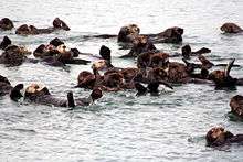
Moss landing is most noted as the gateway to Elkhorn Slough, one of the largest wetlands in the state. Elkhorn Slough is a precious resource and is always ranked in the top 10 best birding spots in the U.S according to the Audubon’s annual bird count. There is over 350 species of birds that migrate through the area annually. It is also known as one of the best spots in the world to see sea otters. The small fishing village of Moss Landing lies in the northern part of Monterey County and has numerous restaurants, galleries, a bed and breakfast, and is homeport to over 600 fishing and pleasure boats.
Moss Landing Harbor District berths over 600 boats: including 350 fishing boats, 200 pleasure craft, 30 research vessels, and a half dozen tour and charter boats. The harbor's commercial boats land dungeness crab, halibut, king salmon, albacore, rockfish, sablefish, anchovies, sardines, squid, black cod, red snapper, covina, prawns, mackrel, and others. Several maritime businesses support harbor users including a fuel dock. The harbor district also provides two public boat launches and a community park.[11]
Parks and nature reserves
Moss Landing provides access to state and federal protected lands, including surfing destination Moss Landing State Beach, Salinas River State Beach, Zmudowski State Beach, Moss Landing Wildlife Area, and the Elkhorn Slough National Estuarine Research Reserve.
References
- 1 2 "Statewide Database". UC Regents. Retrieved November 29, 2014.
- ↑ "California's 20th Congressional District - Representatives & District Map". Civic Impulse, LLC. Retrieved September 24, 2014.
- ↑ "2010 Census U.S. Gazetteer Files – Places – California". United States Census Bureau.
- 1 2 3 4 U.S. Geological Survey Geographic Names Information System: Moss Landing, California
- 1 2 3 4 5 6 Durham, David L. (1998). California's Geographic Names: A Gazetteer of Historic and Modern Names of the State. Clovis, Calif.: Word Dancer Press. p. 927. ISBN 1-884995-14-4.
- ↑ Climate Summary for Moss Landing, California
- ↑ "2010 Census Interactive Population Search: CA - Moss Landing CDP". U.S. Census Bureau. Retrieved July 12, 2014.
- ↑ "American FactFinder". United States Census Bureau. Retrieved 2008-01-31.
- 1 2 "Moss Landing CHamber of Commerce". web site. Retrieved February 16, 2011.
- ↑ SeeMonterey: Moss Landing Antique Street Fair
- ↑ Moss Landing Harbor District
External links
| Wikimedia Commons has media related to Moss Landing, California. |
| Wikivoyage has a travel guide for Moss Landing. |