Mount Hijiri
| Mount Hijiri | |
|---|---|
| 聖岳 | |
.jpg) Mount Hijiri from Mount Yanbushi | |
| Highest point | |
| Elevation | 3,013 m (9,885 ft) |
| Listing | 100 Famous Japanese Mountains |
| Coordinates | 35°25′22″N 138°08′23″E / 35.42278°N 138.13972°ECoordinates: 35°25′22″N 138°08′23″E / 35.42278°N 138.13972°E |
| Geography | |
 Mount Hijiri Aoi-ku, Shizuoka, Shizuoka Prefecture | |
| Parent range | Akaishi Mountains |
| Climbing | |
| Easiest route | Hiking |
Mount Hijiri (聖岳 Hijiri-dake) is a mountain located in the Akaishi Mountains in both Aoi-ku, Shizuoka, Shizuoka Prefecture and Iida, Nagano Prefecture, in the Chūbu region of Japan. It is 3,013 m (9,885 ft) tall and part of the Akaishi Mountains.[1] It is the mountain in Minami Alps National Park located in the south most.[2] It is also included on the list of "100 Famous Japanese Mountains." There are several mountain climbing trails and Mountain hut around the mountain. There is the Hijiri-Daira hut in the Mountain pass in the south.
Animal and Alpine plant
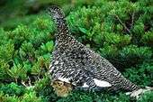
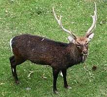
A lot of alpine plants and Rock Ptarmigan are seen in the upper alpine region. Sika Deer is seen in the hillside.
 |
 |
 |
 |
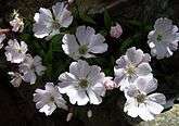
| Silene seen around Mount Ko-Hijiri |
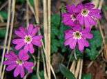
Primula seen around Mount Hijiri-Daira |
Rock Ptarmigan and Siberian Dwarf Pine |
Sika Deer seen around Mount Hijiri-Daira |
Gallery
 |
 |
 |
 |
| Mount Hijiri seen from Mount Minami |
Mount Hijiri seen from Hujiri-Daira |
Mount Akaishi seen from Mount Hijiri |
Mount Oku-Hijiri and Mount Fuji seen from Mount Hijiri |
See also
- Akaishi Mountains
- Minami Alps National Park
- List of mountains in Japan
- 100 Famous Japanese Mountains
- Three-thousanders (in Japan)
References
- ↑ 北岳 [Mount Kita] (in Japanese). Yamanashi NichiNichi Newspaper on Minami Alps Net. Archived from the original on December 25, 2009. Retrieved December 25, 2009.
- ↑ "Minami Alps National Park". Ministry of the Environment (Japan). Retrieved 2011-05-11.
| Wikimedia Commons has media related to Mount Hijiri. |
This article is issued from Wikipedia - version of the 12/17/2014. The text is available under the Creative Commons Attribution/Share Alike but additional terms may apply for the media files.