Mount Yari
| Mount Yari | |
|---|---|
| 槍ヶ岳 | |
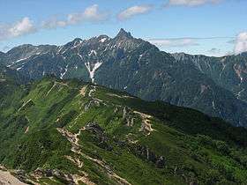 Mount Yari in the centre of the image (A view from Enzansō). | |
| Highest point | |
| Elevation | 3,180 m (10,430 ft) .[1] |
| Coordinates | 36°20′31″N 137°38′51″E / 36.34194°N 137.64750°ECoordinates: 36°20′31″N 137°38′51″E / 36.34194°N 137.64750°E |
| Naming | |
| Translation | spear (Japanese) |
| Pronunciation | Japanese: [jaɽiɡatakeꜜ] |
| Geography | |
 Mount Yari | |
| Parent range | Hida Mountains |
| Climbing | |
| First ascent | July 28, 1828 |
| Easiest route | Hike |
Mount Yari (槍ヶ岳 Yari-ga-take) is one of the 100 Famous Japanese Mountains. The 3,180 m (10,433 ft) high peak lies in the southern part of the Hida Mountains (Northern Alps) of Japan, on the border of Ōmachi and Matsumoto in Nagano Prefecture and Takayama in Gifu Prefecture. The priest Banryū (1786–1840) founded a temple there.
History
- July 28, 1828 - Banryū first climbed the mountain.
- 1878 - William Gowland became the first non-Japanese man to climb to the top.
- August, 1891 - Englishman Walter Weston climbed to the top.[2]
- 1922 - Japanese mountaineer Maki Yūkō made the first winter ascent of the mountain.[3]
- December 4, 1934 - The region in the mountain was specified for the Chūbu-Sangaku National Park.[4]
Outline
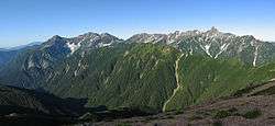
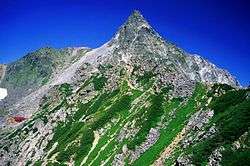
Mount Yari is located in the Chūbu-Sangaku National Park.[4] The name derives from its shape, which resembles a spear (槍 yari) thrust into the sky. Because of its shape, it is also called the Matterhorn of Japan. Ridges and valleys reach out from this pyramid-shaped mountain in all directions. The four ridges are Higashikama (東鎌), Yarihotaka (槍穂高), Nishikama (西鎌) and Kitakama (北鎌) to the east, south, west and north, respectively. The four valleys are Yarizawa (槍沢), Hidazawa or Yaridaira (飛騨沢 or 槍平), Senjōzawa (千丈沢) and Tenjōzawa (天丈沢) to the southeast, southwest, northwest and northeast, respectively.
During the hiking season, Mount Yari is popular with mountain climbers. One of the most famous but dangerous ridges is Kitakama. It became famous through its association with mountaineer Buntarō Katō (加藤 文太郎 Katō Buntarō), who was a model for the novel Kokō no Hito (孤高の人) by Jirō Nitta. The disaster of Akira Matsunami (松濤明 Matsunami Akira) told in Fūsetsu no Bibāgu (風雪のビバーグ Snowstorm Bivouac) also contributed to its fame.
Despite the existence of variation routes, climbers stand in line for the famous routes during the summer. In the autumn of 2005, a new mountain trail was constructed going up from Hidarimata Valley (左俣谷 Hidarimata-dani) to Mount Okumaru (奥丸山 Okumaru-yama). This made it possible to reach Yari-ga-take walking from Shinhodaka onsen upstream along the Hidarimata Valley following the mountain ridge of Mount Okumaru.
Two triangulation points were established at the summit. A milepost stone is fixed to the ground. As a reference point for the Geographical Survey Institute of Japan, it is of little importance and even on topographic maps, the summit of Yari-ga-take appears merely as an elevation point.
Surroundings
There are several mountain huts in the vicinity of the mountain: Yari-ga-take Sansō (槍ヶ岳山荘), Sesshō Hut (殺生ヒュッテ), Hut Ōyari (ヒュッテ大槍), Yarisawa Lodge (槍沢ロッジ), Yaridaira-goya (槍平小屋) and Wasabidaira-goya (わさび平小屋). Being situated in the Japanese Alps, several prominent mountains can be reached from Mount Yari, among them: Sugoroku-dake (双六岳), Nishi-dake (西岳), Ōgui-dake (大喰岳), Naka-dake (中岳), Minami-dake (南岳), Okumaru-yama (奥丸山).
Main ascent routes
- Higashikama ridge (Omoteginza (表銀座) route)
- Nakabusa Onsen (中房温泉) ― Tsubakuro-dake (燕岳) ― Otensho-dake (大天井岳) ― Higashikama ridge ― Yari-ga-take
- Nishikama ridge (Uraginza (裏銀座) route)
- Takase dam (高瀬ダム) ― Eboshi-dake (烏帽子岳) ― Noguchigorō-dake ― Washiba-dake (鷲羽岳) ― Sugoroku-dake (双六岳) ― もみさわだけ Momizawa-dake (樅沢岳) ― Nishikama ridge ― Yariga-take
- Yarisawa (槍沢) route
- Kamikōchi (上高地) ― Myōjinike (明神池) ― Tokusawa (徳沢) ― Yokoo (横尾) ― Yarisawa lodge ― Yari-ga-take
- Yaridaira route
- Shinhodaka Onsen ― Migimatadani (右俣谷) ― Yaridaira ― Yari-ga-take
- Wasabidaira (わさび平) route
- Shinhodaka Onsen ― Hidarimatadani (左俣谷) ― Wasabidaira ― Okumaru-yama ― Nakazaki ridge (中崎尾根) ― Yari-ga-take
- Kitakama ridge (variation route)
- Takase dam ― Yumata-onsen-seiransō (湯俣温泉晴嵐荘) ― (千天出合) ― Kitakama ridge ― Yari-ga-take
- Yarihotaka traverse (槍穂高縦走) route
- Kamikōchi ― Maehotaka-dake (前穂高岳) ― Okuhotaka-dake (奥穂高岳) ― Hotakadake mountain cottage (穂高岳山荘) ― Karasawa-dake (涸沢岳) ― Kitahotaka-dake (北穂高岳) ― Daikiretto (大キレット) ― Minami-dake (南岳) ― Ōbami-dake (Ōbami-dake 大喰岳) ― Yari-ga-take
See also
| Wikimedia Commons has media related to Mount Yari. |
- List of mountains in Japan
- 100 Famous Japanese Mountains
- Three-thousanders (in Japan)
- Hida Mountains
- Chūbu-Sangaku National Park
References
- ↑ "Altitude of the main mountain in Japan (in Nagano)" (in Japanese). Geospatial Information Authority of Japan. Retrieved 2011-03-31.
- ↑ "Mountaineeraing and exploration in Japanese alps, (in 1896 by Walter Weston)" (new ed.). translated into Japanese (日本アルプスの登山と探検), Iwanami Shoten, ISBN 4-00-334741-2. 2005.
- ↑ Douglas, Ed (2011). Mountaineers: Great Tales of Bravery and Conquest. Smithsonian Institution. New York, New York: DK Publishing. p. 212. ISBN 978-0-7566-8682-6.
- 1 2 "Chūbu-Sangaku National Park". Ministry of the Environment (Japan). Retrieved 2011-03-31.
External links
- Topographic map (1:25,000)