Moxi Town
| Moxi | |
|---|---|
| Township | |
| Tibetan transcription(s) | |
| Chinese transcription(s) | |
| • Traditional | 磨西镇 |
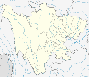 Moxi Location in Sichuan | |
| Coordinates: 29°40′N 102°7′E / 29.667°N 102.117°ECoordinates: 29°40′N 102°7′E / 29.667°N 102.117°E | |
| Country | China |
| Province | Sichuan |
| Prefecture | Garzê Tibetan Autonomous Prefecture |
| County | Luding County |
| Area | |
| • Total | 308.64 km2 (119.17 sq mi) |
| Population (2000) | |
| • Total | 6,794 |
| • Density | 22/km2 (57/sq mi) |
| Time zone | CST (UTC+8) |
Moxi is a town and township in Luding County in the Garzê Tibetan Autonomous Prefecture of Sichuan, China. As of 2000 it had 6,794 inhabitants. Moxi Town stands at the gateway to the Hailuogou Glacier Forest Park, south of Kangding and east of Mount Gongga. The town also featured in the Battle of Luding Bridge in 1935 when some of those who fought in the battle including Mao Zedong met in Moxi and stayed the night when the army marched through before heading north.
Moxi lies at roughly 1,600 meters above sea level, and the population are mainly ethnic Han Chinese, Yi and Tibetan with other minorities.
The main crossroads at the park entrance has hotels, restaurants and souvenir stalls. About 150 metres below is the original street of the village. It has a small Catholic church built in the 1920s with a colourful bell tower and a number of wooden shops.[1]
The surrounding township is mainly pastoral land, and agriculture employs much of the population.
Footnotes
- ↑ Leffman (2005), p. 948.
References
- Leffman, David, et al. (2005). The Rough Guide to China. 4th Edition. Rough Guides, New York, London, Delhi. ISBN 978-1-84353-479-2.
External links
- Dreams Travel.com
- Moxi at Baidu (Chinese)
| County-level divisions |   | |
|---|---|---|
| Towns and villages |
| |
| Geography | ||
| Landmarks | ||