Garzê County
| Garzê County དཀར་མཛེས། 甘孜县 | |
|---|---|
| County | |
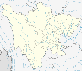
 Garzê Location in Sichuan | |
| Coordinates: 31°37′23″N 100°00′04″E / 31.623°N 100.001°ECoordinates: 31°37′23″N 100°00′04″E / 31.623°N 100.001°E | |
| Country | People's Republic of China |
| Province | Sichuan |
| Autonomous prefecture | Garzê |
| Area | |
| • Total | 7,364 km2 (2,843 sq mi) |
| Highest elevation | 5,688 m (18,661 ft) |
| Lowest elevation | 3,325 m (10,909 ft) |
| Population | |
| • Total | 56,000 |
| • Density | 7.6/km2 (20/sq mi) |
| Postal code | 624000 |
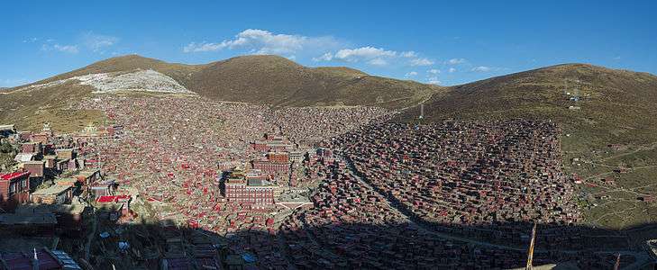
Garzê County (Tibetan: དཀར་མཛེས་རྫོང།, Wylie: dkar mdzes rdzong, ZYPY: Garzê Zong ; Chinese: 甘孜县; pinyin: Gānzī Xiàn) is one of the 18 subdivisions of the Garzê Tibetan Autonomous Prefecture, in northwestern Sichuan province, China. The Yalong River passes just south of the town Garzê, also known as Ganzi, the capital town of the county, which has some 9,000 inhabitants (2008), many of them ethnic Tibetans, and is famous for its Tibetan lamasery. Historically, it is part of the Tibetan cultural region of Kham and now defunct province of Xikang (or Sikang). It lies on the northern section of the Sichuan-Tibet Highway.
Geography
Due to its elevation, Garzê County has a monsoon-influenced humid continental climate (Köppen Dwb), with cold but very dry winters, and warm summers with frequent rain. The monthly 24-hour average temperature ranges from −4.4 °C (24.1 °F) in January to 13.9 °C (57.0 °F) in July, while the annual mean is 5.64 °C (42.2 °F). Over two-thirds of the annual precipitation of 660 mm (26.0 in) occurs from June thru September. With monthly percent possible sunshine ranging from 49% in July to 74% in November and December, the county seat receives abundant, outside of summer, sunshine, totalling 2,620 hours annually. The diurnal temperature variation is large, averaging 14.5 °C (26.1 °F) annually.
Towns and Townships
- Garzê Town (甘孜镇)
- Nanduo Township (南多乡)
- Shengkang Township (生康乡)
- Gonglong Township (贡隆乡)
- Zheke Township (扎科乡)
- Laima Township (来马乡)
- Xise Township (昔色乡)
- Kagong Township (卡攻乡)
- Renguo Township (仁果乡)
- Tuoba Township (拖坝乡)
- Si'e Township (斯俄乡)
- Tingka Township (庭卡乡)
- Xiaxiong Township (下雄乡)
- Sitongda Township (四通达乡)
- Duoduo Township (夺多乡)
- Nike Township (泥柯乡)
- Chazha Township (茶扎乡)
- Dade Township (大德乡)
- Kalong Township (卡龙乡)
- Chalong Township (查龙乡)
| Climate data for Garzê County (1971−2000) | |||||||||||||
|---|---|---|---|---|---|---|---|---|---|---|---|---|---|
| Month | Jan | Feb | Mar | Apr | May | Jun | Jul | Aug | Sep | Oct | Nov | Dec | Year |
| Average high °C (°F) | 5.1 (41.2) |
7.6 (45.7) |
11.2 (52.2) |
14.6 (58.3) |
18.2 (64.8) |
20.2 (68.4) |
21.0 (69.8) |
21.0 (69.8) |
18.7 (65.7) |
14.9 (58.8) |
9.9 (49.8) |
5.5 (41.9) |
13.99 (57.2) |
| Average low °C (°F) | −11.5 (11.3) |
−8 (18) |
−3.8 (25.2) |
−0.4 (31.3) |
3.9 (39) |
7.3 (45.1) |
8.4 (47.1) |
7.6 (45.7) |
5.9 (42.6) |
1.2 (34.2) |
−6 (21) |
−10.9 (12.4) |
−0.52 (31.06) |
| Average precipitation mm (inches) | 5.1 (0.201) |
8.5 (0.335) |
19.5 (0.768) |
34.7 (1.366) |
79.2 (3.118) |
133.4 (5.252) |
116.7 (4.594) |
94.1 (3.705) |
109.5 (4.311) |
46.0 (1.811) |
8.6 (0.339) |
4.5 (0.177) |
659.8 (25.977) |
| Average precipitation days (≥ 0.1 mm) | 3.9 | 5.9 | 8.8 | 12.3 | 17.8 | 22.1 | 21.6 | 18.6 | 19.2 | 13.0 | 4.7 | 3.0 | 150.9 |
| Average relative humidity (%) | 45 | 45 | 48 | 53 | 57 | 67 | 72 | 71 | 72 | 65 | 53 | 49 | 58.1 |
| Mean monthly sunshine hours | 220.5 | 202.7 | 221.4 | 223.5 | 235.7 | 212.7 | 211.7 | 208.0 | 198.3 | 220.7 | 232.7 | 232.4 | 2,620.3 |
| Percent possible sunshine | 69 | 65 | 60 | 58 | 56 | 50 | 49 | 51 | 54 | 63 | 74 | 74 | 59 |
| Source: China Meteorological Administration [1] | |||||||||||||
Transport
References
- ↑ 中国地面国际交换站气候标准值月值数据集(1971-2000年) (in Chinese). China Meteorological Administration. Retrieved 2010-05-04.
External links
| Wikivoyage has a travel guide for Ganzi. |

