Munising, Michigan
| Munising, Michigan | |
|---|---|
| City | |
|
Munising, Michigan | |
 Location of Munising, Michigan | |
| Coordinates: 46°24′38″N 86°38′51″W / 46.41056°N 86.64750°W | |
| Country | United States |
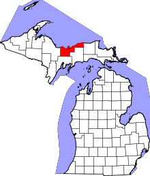
| State | Michigan |
| County | Alger |
| Area[1] | |
| • Total | 9.03 sq mi (23.39 km2) |
| • Land | 5.25 sq mi (13.60 km2) |
| • Water | 3.78 sq mi (9.79 km2) |
| Elevation | 614 ft (187 m) |
| Population (2010)[2] | |
| • Total | 2,355 |
| • Estimate (2012[3]) | 2,329 |
| • Density | 448.6/sq mi (173.2/km2) |
| Time zone | Eastern (EST) (UTC-5) |
| • Summer (DST) | EDT (UTC-4) |
| ZIP code | 49862 |
| Area code(s) | 906 |
| FIPS code | 26-56200[4] |
| GNIS feature ID | 1620952[5] |

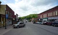
Munising is a city on the southern shore of Lake Superior on the Upper Peninsula of the U.S. state of Michigan. The population was 2,355 at the 2010 census. It is the county seat of Alger County.[6] The city is adjacent to the northwest corner of Munising Township, but is administratively autonomous.
History
The name for the city comes from the Ojibwe word for "island at".[7] A post office was established as the Munising post office on December 22, 1868. It was renamed as Gogarnville on October 23, 1889, when Julius Gogarn was appointed as postmaster. The office was moved to his farm. He was a German-born American Civil War veteran and first Supervisor of Munising Township. That post office continued until July 15, 1893.[8][9]
Geography
Munising is located on the southern edge of Munising Bay at 46°24′40″N 86°38′52″W / 46.41111°N 86.64778°W, also known as the South Bay of Grand Island Harbor, across from Grand Island around the mouth of the Anna River. It is the primary embarkation point for cruises to Pictured Rocks National Lakeshore and Grand Island National Recreation Area.
The name Munising is derived from the Ojibway language. 'Munissi' means island. 'Munising' means near the island. Grand Island is located one half mile north in Munising Bay.
According to the United States Census Bureau, the city has a total area of 9.03 square miles (23.39 km2), of which 5.25 square miles (13.60 km2) is land and 3.78 square miles (9.79 km2) is water.[1]
The Munising area has many waterfalls including Alger Falls, Horseshoe Falls, Memorial Falls, Munising Falls, Miners Falls, Scott Falls, Tannery Falls and Wagner Falls.
Climate
| Climate data for Munising, Michigan (1981–2010 normals, extremes 1911–present) | |||||||||||||
|---|---|---|---|---|---|---|---|---|---|---|---|---|---|
| Month | Jan | Feb | Mar | Apr | May | Jun | Jul | Aug | Sep | Oct | Nov | Dec | Year |
| Record high °F (°C) | 58 (14) |
57 (14) |
82 (28) |
89 (32) |
95 (35) |
97 (36) |
103 (39) |
103 (39) |
99 (37) |
87 (31) |
70 (21) |
60 (16) |
103 (39) |
| Average high °F (°C) | 24.5 (−4.2) |
26.8 (−2.9) |
35.1 (1.7) |
47.4 (8.6) |
60.0 (15.6) |
69.1 (20.6) |
74.1 (23.4) |
73.3 (22.9) |
65.5 (18.6) |
53.1 (11.7) |
39.9 (4.4) |
28.8 (−1.8) |
49.8 (9.9) |
| Daily mean °F (°C) | 17.9 (−7.8) |
19.4 (−7) |
27.7 (−2.4) |
39.0 (3.9) |
50.0 (10) |
59.1 (15.1) |
64.8 (18.2) |
64.5 (18.1) |
57.3 (14.1) |
45.6 (7.6) |
34.0 (1.1) |
22.9 (−5.1) |
41.9 (5.5) |
| Average low °F (°C) | 11.3 (−11.5) |
12.0 (−11.1) |
20.3 (−6.5) |
30.6 (−0.8) |
39.9 (4.4) |
49.1 (9.5) |
55.6 (13.1) |
55.7 (13.2) |
49.1 (9.5) |
38.1 (3.4) |
28.0 (−2.2) |
17.1 (−8.3) |
33.9 (1.1) |
| Record low °F (°C) | −27 (−33) |
−33 (−36) |
−26 (−32) |
−15 (−26) |
10 (−12) |
21 (−6) |
31 (−1) |
24 (−4) |
22 (−6) |
4 (−16) |
−10 (−23) |
−21 (−29) |
−33 (−36) |
| Average precipitation inches (mm) | 3.27 (83.1) |
2.01 (51.1) |
2.09 (53.1) |
2.20 (55.9) |
2.98 (75.7) |
3.36 (85.3) |
3.27 (83.1) |
3.48 (88.4) |
4.07 (103.4) |
4.23 (107.4) |
3.74 (95) |
3.75 (95.3) |
38.45 (976.6) |
| Average snowfall inches (cm) | 43.3 (110) |
26.5 (67.3) |
18.8 (47.8) |
7.6 (19.3) |
0.3 (0.8) |
0.0 (0) |
0.0 (0) |
0.0 (0) |
0.0 (0) |
1.4 (3.6) |
13.0 (33) |
41.2 (104.6) |
152.1 (386.3) |
| Average precipitation days (≥ 0.01 in) | 20.2 | 14.1 | 11.1 | 9.7 | 11.1 | 10.3 | 10.5 | 10.1 | 13.2 | 15.4 | 15.1 | 18.3 | 159.1 |
| Average snowy days (≥ 0.1 in) | 19.3 | 13.2 | 8.5 | 2.8 | 0.2 | 0.0 | 0.0 | 0.0 | 0.0 | 1.0 | 6.4 | 15.8 | 67.2 |
| Source: NOAA[10][11] | |||||||||||||
Demographics
| Historical population | |||
|---|---|---|---|
| Census | Pop. | %± | |
| 1880 | 135 | — | |
| 1900 | 2,014 | — | |
| 1910 | 2,952 | 46.6% | |
| 1920 | 5,037 | 70.6% | |
| 1930 | 3,956 | −21.5% | |
| 1940 | 4,409 | 11.5% | |
| 1950 | 4,339 | −1.6% | |
| 1960 | 4,228 | −2.6% | |
| 1970 | 3,677 | −13.0% | |
| 1980 | 3,083 | −16.2% | |
| 1990 | 2,783 | −9.7% | |
| 2000 | 2,539 | −8.8% | |
| 2010 | 2,355 | −7.2% | |
| Est. 2015 | 2,288 | [12] | −2.8% |
2010 census
As of the census[2] of 2010, there were 2,355 people, 1,032 households, and 592 families residing in the city. The population density was 448.6 inhabitants per square mile (173.2/km2). There were 1,252 housing units at an average density of 238.5 per square mile (92.1/km2). The racial makeup of the city was 91.2% White, 0.2% African American, 4.8% Native American, 0.7% Asian, 0.2% from other races, and 3.0% from two or more races. Hispanic or Latino of any race were 1.4% of the population.
There were 1,032 households of which 22.9% had children under the age of 18 living with them, 42.0% were married couples living together, 11.0% had a female householder with no husband present, 4.4% had a male householder with no wife present, and 42.6% were non-families. 37.9% of all households were made up of individuals and 20.2% had someone living alone who was 65 years of age or older. The average household size was 2.13 and the average family size was 2.76.
The median age in the city was 48.6 years. 18.7% of residents were under the age of 18; 6% were between the ages of 18 and 24; 20.5% were from 25 to 44; 28.4% were from 45 to 64; and 26.3% were 65 years of age or older. The gender makeup of the city was 47.4% male and 52.6% female.
2000 census
As of the census[4] of 2000, there were 2,539 people, 1,115 households, and 654 families residing in the city. The population density was 474.0 per square mile (182.9/km²). There were 1,249 housing units at an average density of 233.2 per square mile (90.0/km²). The racial makeup of the city was 93.74% White, 0.16% African American, 3.51% Native American, 0.67% Asian, 0.12% Pacific Islander, 0.08% from other races, and 1.73% from two or more races. Hispanic or Latino of any race were 0.98% of the population. 13.3% were of French, 12.4% German, 11.0% Finnish, 9.9% Polish, 8.8% Swedish, 7.3% French Canadian and 6.8% Irish ancestry according to Census 2000. 97.8% spoke English and 1.6% Spanish as their first language.
There were 1,115 households out of which 24.4% had children under the age of 18 living with them, 44.8% were married couples living together, 10.2% had a female householder with no husband present, and 41.3% were non-families. 36.3% of all households were made up of individuals and 19.5% had someone living alone who was 65 years of age or older. The average household size was 2.17 and the average family size was 2.82.

In the city the population was spread out with 21.4% under the age of 18, 6.6% from 18 to 24, 23.5% from 25 to 44, 23.4% from 45 to 64, and 25.1% who were 65 years of age or older. The median age was 44 years. For every 100 females there were 88.8 males. For every 100 females age 18 and over, there were 82.9 males.
The median income for a household in the city was $33,899, and the median income for a family was $46,133. Males had a median income of $41,333 versus $24,444 for females. The per capita income for the city was $19,779. About 7.4% of families and 11.4% of the population were below the poverty line, including 11.6% of those under age 18 and 10.1% of those age 65 or over.
Transportation

 M-28 travels west to Marquette and east to Sault Ste. Marie.
 M-94 travels westerly through Chatham toward Sawyer International Airport south of Marquette, and southerly to Manistique.
 H-11 runs from H-58 just east of the city to Miner's Castle within Pictured Rocks National Lakeshore.
 H-13, a north-south route, terminates at H-58 in the eastern part of the city.
 H-58 begins in downtown Munising and continues northeasterly through Pictured Rocks National Lakeshore.
Notable people
- Connie Binsfeld, 58th Lieutenant Governor of Michigan[14]
- George Snow Hill, painter[15]
- Brock Strom, professional football player[14]
- James Wickstrom, radio talk show host[14]
References
- 1 2 "US Gazetteer files 2010". United States Census Bureau. Retrieved 2012-11-25.
- 1 2 "American FactFinder". United States Census Bureau. Retrieved 2012-11-25.
- ↑ "Population Estimates". United States Census Bureau. Retrieved 2013-06-03.
- 1 2 "American FactFinder". United States Census Bureau. Retrieved 2008-01-31.
- ↑ U.S. Geological Survey Geographic Names Information System: Munising, Michigan
- ↑ "Find a County". National Association of Counties. Retrieved 2011-06-07.
- ↑ "Profile for Munising, Michigan, MI". ePodunk. Retrieved June 23, 2014.
- ↑ Romig, Walter (1986) [1973]. Michigan Place Names. Detroit, Michigan: Wayne State University Press. ISBN 0-8143-1838-X.
- ↑ U.S. Geological Survey Geographic Names Information System: Gogarnville Post Office (historical)
- ↑ "NowData - NOAA Online Weather Data". National Oceanic and Atmospheric Administration. Retrieved July 29, 2016.
- ↑ "MI Munising". National Oceanic and Atmospheric Administration. Retrieved July 29, 2016.
- ↑ "Annual Estimates of the Resident Population for Incorporated Places: April 1, 2010 to July 1, 2015". Retrieved July 2, 2016.
- ↑ "Census of Population and Housing". Census.gov. Retrieved June 4, 2015.
- 1 2 3 "Munising, Michigan". City-Data.com. Retrieved June 23, 2014.
- ↑ "Cypress Logging (mural study, Perry, Florida Post Office)". Smithsonian American Art Museum. Retrieved June 23, 2014.
Further reading
- Romig, Walter. Michigan Place Names. Wayne State University Press: Detroit, 1986.
External links
![]() Media related to Munising, Michigan at Wikimedia Commons
Media related to Munising, Michigan at Wikimedia Commons
- Munising Visitor's Bureau
- City of Munising Website
- Munising Area Information
- Munising Area Tourism, History, Our Town, Economic Development
- Explore Munising! Travel and Adventure Guide Website
- Alger County Sheriff's Office
- USCG Auxiliary Flotilla 26-12
- Pictured Rocks National Lakeshore
Coordinates: 46°24′40″N 86°38′52″W / 46.41111°N 86.64778°W