Murphys, California
| Murphys | |
|---|---|
| Census designated place | |
|
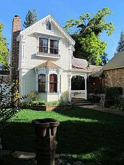
Old house in Murphys | |
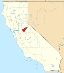
 Location in Calaveras County and the state of California | |
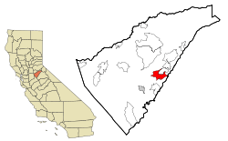
 Murphys Location in the United States | |
| Coordinates: 38°8′N 120°28′W / 38.133°N 120.467°WCoordinates: 38°8′N 120°28′W / 38.133°N 120.467°W | |
| Country |
|
| State |
|
| County | Calaveras |
| Area[1] | |
| • Total | 10.323 sq mi (26.738 km2) |
| • Land | 10.321 sq mi (26.732 km2) |
| • Water | 0.002 sq mi (0.006 km2) 0.02% |
| Elevation[2] | 2,172 ft (662 m) |
| Population (April 1, 2010) | |
| • Total | 2,213 |
| • Density | 210/sq mi (83/km2) |
| Time zone | Pacific (UTC-8) |
| • Summer (DST) | PDT (UTC-7) |
| ZIP codes | 95229, 95247 |
| Area code | 209 |
| FIPS code | 06-50034 |
| GNIS feature IDs | 277560, 2408892 |
| Reference no. | 275 |
Murphys (formerly Murphy, Murphy's, Murphy's Camp, Murphy's Diggins, Murphys New Diggings, and Queen of the Sierra) is a census-designated place (CDP) in Calaveras County, California, United States. It's been called "The next Napa (Valley)." The population was 2,213 at the 2010 census, up from 2,061 at the 2000 census.
History
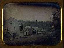
John and Daniel Murphy were part of the Stephens-Townsend-Murphy Party, the first immigrant party to bring wagons across the Sierra Nevada to Sutter's Fort in 1844. They earned a living as merchants, but like many others, began prospecting when the California Gold Rush began. They first started in Vallecito, which was known as "Murphys Old Diggings," before moving to another location in 1848 which became "Murphys New Diggings," "Murphy's Camp," and eventually just "Murphys."
The placer mining in this location was wildly successful. Miners were limited to claims of 8 square feet (0.75 m2) and yet many were still able to become rich. The Murphy brothers themselves, however, made far more money as merchants than as miners. In fact, John was so successful that he left town at the end of 1849 and never returned, having amassed a personal fortune of nearly $2 million. Roughly $20 million in gold was discovered in Murphys and the surrounding area. Two of the richest diggings were named Owlsburg and Owlburrow Flat.[3]
Murphys was also a popular destination as a tourist resort, as the nearby giant sequoia trees in what is now Calaveras Big Trees State Park were a major draw, and they continue to be so today. After visiting, John Muir wrote in his book, The Mountains of California (1894):
"MURPHY'S CAMP is a curious old mining-town in Calaveras County, at an elevation of 2,400 feet (730 m) above the sea, situated like a nest in the center of a rough, gravelly region, rich in gold. Granites, slates, lavas, limestone, iron ores, quartz veins, auriferous gravels, remnants of dead fire-rivers and dead water-rivers are developed here side by side within a radius of a few miles, and placed invitingly open before the student like a book, while the people and the region beyond the camp furnish mines of study of never-failing interest and variety."
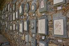
Like many other mining towns, fire was its bane and the town was destroyed three times by flames, in 1859, 1874, and 1893. After the second major fire, there was little gold left to mine, and so the town was never rebuilt to its boomtown condition. However, Murphys continued to thrive as a merchant center, supplying many of the silver mines in Nevada with provisions via Ebbetts Pass. The town is registered as California Historical Landmark #275.[4] A "Hall of Comparative Ovations" built by a chapter of the clampers still stands in Murphys. The picture below labeled "Murphys' Famous Residents Wall" is a picture of the "Wall of Comparative Ovations" at the "Old Timer Museum" in Murphys, CA. The plaques on the wall are installed and maintained by members of "E Clampus Vitus."
The first post office was established as Murphy's in 1851. The name was changed to Murphy in 1894, and finally to Murphys in 1935.[3]
Geography
According to the United States Census Bureau, the CDP has a total area of 10.3 square miles (27 km2), 99.98% of it land.
Climate
This region experiences warm to very hot, dry summers, with average monthly temperatures above 71.6 °F (22.0 °C), and many days above 100 °F (38 °C) during summer months. According to the Köppen Climate Classification system, Murphys has a warm-summer Mediterranean climate, abbreviated "Csb" on climate maps.[5]
Demographics
2010
The 2010 United States Census[6] reported that Murphys had a population of 2,213. The population density was 214.4 people per square mile (82.8/km²). The racial makeup of Murphys was 2,045 (92.4%) White, 9 (0.4%) African American, 17 (0.8%) Native American, 7 (0.3%) Asian, 10 (0.5%) Pacific Islander, 82 (3.7%) from other races, and 43 (1.9%) from two or more races. Hispanic or Latino of any race were 223 persons (10.1%).
The Census reported that 2,213 people (100% of the population) lived in households, 0 (0%) lived in non-institutionalized group quarters, and 0 (0%) were institutionalized.
There were 1,053 households, out of which 219 (20.8%) had children under the age of 18 living in them, 505 (48.0%) were opposite-sex married couples living together, 81 (7.7%) had a female householder with no husband present, 37 (3.5%) had a male householder with no wife present. There were 41 (3.9%) unmarried opposite-sex partnerships, and 7 (0.7%) same-sex married couples or partnerships. 378 households (35.9%) were made up of individuals and 226 (21.5%) had someone living alone who was 65 years of age or older. The average household size was 2.10. There were 623 families (59.2% of all households); the average family size was 2.70.
The population was spread out with 401 people (18.1%) under the age of 18, 109 people (4.9%) aged 18 to 24, 327 people (14.8%) aged 25 to 44, 726 people (32.8%) aged 45 to 64, and 650 people (29.4%) who were 65 years of age or older. The median age was 54.1 years. For every 100 females there were 83.0 males. For every 100 females age 18 and over, there were 80.5 males.
There were 1,256 housing units at an average density of 121.7 per square mile (47.0/km²), of which 726 (68.9%) were owner-occupied, and 327 (31.1%) were occupied by renters. The homeowner vacancy rate was 4.1%; the rental vacancy rate was 6.5%. 1,491 people (67.4% of the population) lived in owner-occupied housing units and 722 people (32.6%) lived in rental housing units.
2000
As of the census[7] of 2000, there were 2,061 people, 945 households, and 611 families residing in the CDP. The population density was 200.0 people per square mile (77.2/km²). There were 1,094 housing units at an average density of 106.2 per square mile (41.0/km²). The racial makeup of the CDP was 94.27% White, 0.34% Black or African American, 0.97% Native American, 0.87% Asian, 0.10% Pacific Islander, 2.38% from other races, and 1.07% from two or more races. 5.63% of the population were Hispanic or Latino of any race.
There were 945 households out of which 22.0% had children under the age of 18 living with them, 55.7% were married couples living together, 6.2% had a female householder with no husband present, and 35.3% were non-families. 30.7% of all households were made up of individuals and 19.4% had someone living alone who was 65 years of age or older. The average household size was 2.18 and the average family size was 2.71.
In the CDP the population was spread out with 19.8% under the age of 18, 4.0% from 18 to 24, 19.6% from 25 to 44, 28.0% from 45 to 64, and 28.5% who were 65 years of age or older. The median age was 49 years. For every 100 females there were 88.2 males. For every 100 females age 18 and over, there were 85.3 males.
The median income for a household in the CDP was $42,344, and the median income for a family was $58,194. Males had a median income of $44,125 versus $31,394 for females. The per capita income for the CDP was $24,567. About 6.6% of families and 10.0% of the population were below the poverty line, including 19.4% of those under age 18 and 4.5% of those age 65 or over.
Arts and culture
Annual cultural events
Calaveras Wine Alliance members host Presidents Weekend (February) Open House; Passport Weekend (June); Vineyard Tour (July). All member tasting rooms are open to the public. In October, a Grape Stomp takes place at Murphys Park. March brings Irish Days. The Calveras County Fair in May features the Frog Jumping Contest made famous in the 1865 short by Mark Twain, "The Jumping Frog of Calaveras County".[8]
The Ironstone Concours d'Elegance car show is held annually in Murphys at the Ironstone Vineyard. Proceeds from the event benefit the 4-H Club and Future Farmers of America.[9] Also, Ironstone hosts concerts every year. Past seasons have featured acts such as Coldplay; the Russian National Orchestra; Dave Koz; Robert Cray; Michael McDonald[7]; The Doobie Brothers; Los Lonely Boys[8]; Earth, Wind & Fire; Gretchen Wilson; John Michael Montgomery; Lynyrd Skynyrd; UB40; Vince Gill; Amy Grant; Carrie Underwood; Randy Travis; Bryan Adams; George Thorogood; Peter Frampton; B. B. King; Boz Skaggs; Huey Lewis and the News; Steely Dan; ZZ Top; Chris Isaak; Bonnie Raitt; The Moody Blues; Willie Nelson; Alan Jackson; Crosby, Stills & Nash; Faith Hill; Chicago; The Fray; Chicago; Sugarland; Faith Hill; ZZ Top; Sheryl Crow; REO Speedwagon; Heart; Kansas; Pat Benatar; Joan Jett & the Blackhearts; Al Green; Coldplay; Bob Weir; and many others.[9]
Museums and other points of interest

- Murphys Hotel (CHL #267), one of the oldest continually operating hotels in California. Its historic register contains such names as Ulysses S. Grant and Mark Twain.
- The Old Mining Camp of Brownsville (CHL #465) sits just to southwest of the town. A thriving mining camp on rich Pennsylvania Gulch in the 1850s and 1860s, the camp was named for Alfred Brown, former owner of Table Mountain Ranch. Laws of the Brownsville mining district provided that each miner could own one wet and one dry claim, not to exceed 150 square feet (14 m2) each
- The Peter L. Traver Building (CHL #466) is the oldest stone building in Murphys. Its iron shutters and sand on the roof protected it from the fires of 1859, 1874, and 1893. It served as a general store, a Wells Fargo office, and later a garage. Today, it houses a not-for-profit museum documenting Murphys' gold-rush history.
- Mercer Caverns
- Moaning Cavern
- Murphys is well known for its beautiful vineyards and award winning wines. Visitors can enjoy the unique experience of having 25 tasting rooms along the Murphys Main Street, all within walking distance.
Politics
In the state legislature, Murphys is in the 8th Senate District, represented by Republican Tom Berryhill,[10] and the 5th Assembly District, represented by Republican Frank Bigelow.[11] Federally, Murphys is in California's 4th congressional district, represented by Republican Tom McClintock.[12]
Famous residents
- Albert Abraham Michelson, the first American to receive the Nobel in the sciences, grew up in Murphy's Camp and Virginia City, Nevada. The elementary school is named for him.
References
- ↑ "2010 Census U.S. Gazetteer Files – Places – California". United States Census Bureau.
- ↑ "Murphys". Geographic Names Information System. United States Geological Survey. Retrieved January 8, 2015.
- 1 2 Durham, David L. (1998). California's Geographic Names: A Gazetteer of Historic and Modern Names of the State. Clovis, Calif.: Word Dancer Press. p. 808. ISBN 1-884995-14-4.
- ↑ "Murphys". Office of Historic Preservation, California State Parks. Retrieved 2012-10-06.
- ↑ Climate Summary for Murphys, California
- ↑ "2010 Census Interactive Population Search: CA - Murphys CDP". U.S. Census Bureau. Retrieved July 12, 2014.
- ↑ "American FactFinder". United States Census Bureau. Retrieved 2008-01-31.
- ↑ Calaveras Wine Alliance
- ↑ Leven, Michael (January 2011). "2010 Ironstone Concours d'Elegance". Sports Car Market: 38.
- ↑ "Senators". State of California. Retrieved March 21, 2013.
- ↑ "Members Assembly". State of California. Retrieved March 21, 2013.
- ↑ "California's 4th Congressional District - Representatives & District Map". Civic Impulse, LLC. Retrieved March 2, 2013.
| Wikimedia Commons has media related to Murphys, California. |
External links
- http://www.city-data.com/city/Murphys-California.html City Data - Murphys, CA