Mylopotamos, Crete
| Mylopotamos Μυλοπόταμος | |
|---|---|
 | |
 Mylopotamos | |
|
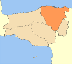
Location within the region 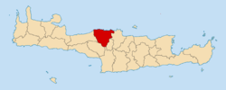 | |
| Coordinates: 35°22′N 24°45′E / 35.367°N 24.750°ECoordinates: 35°22′N 24°45′E / 35.367°N 24.750°E | |
| Country | Greece |
| Administrative region | Crete |
| Regional unit | Rethymno |
| Area | |
| • Municipality | 337.9 km2 (130.5 sq mi) |
| Population (2011)[1] | |
| • Municipality | 14,363 |
| • Municipality density | 43/km2 (110/sq mi) |
| Time zone | EET (UTC+2) |
| • Summer (DST) | EEST (UTC+3) |
Mylopotamos (Greek: Μυλοπόταμος; Mylopotamus in Latin) is a municipality in Rethymno regional unit, on Crete, southern Greece. The seat of the municipality is the village Perama.[2]
Municipality
The municipality Mylopotamos was formed at the 2011 local government reform by the merger of the following 3 former municipalities, which became municipal units:[2]
Former Province
The province of Mylopotamos (Greek: Επαρχία Μυλοποτάμου) was one of the provinces of Rethymno Prefecture. Its territory corresponded with that of the current municipalities Mylopotamos and Anogeia.[3] It was abolished in 2006.
Ecclesiastical history
Modern Lefterna was the seat since 1212 of a Latin Roman Catholic Diocese of Milopotamus, which was suppressed in 1669 and turned into a Latin Titular bishopric of lowest (episcopal), which had its name changed in the 20the century into titular see of Eleutherna.
References
- ↑ "Απογραφή Πληθυσμού - Κατοικιών 2011. ΜΟΝΙΜΟΣ Πληθυσμός" (in Greek). Hellenic Statistical Authority.
- 1 2 Kallikratis law Greece Ministry of Interior (Greek)
- ↑ "Detailed census results 1991" (PDF). (39 MB) (Greek) (French)
Administrative division of the Crete Region | ||
|---|---|---|
Regional unit of Chania | 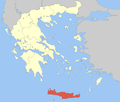 | |
Regional unit of Heraklion | ||
Regional unit of Lasithi | ||
Regional unit of Rethymno | ||
| ||