North American Datum

| Geodesy | ||||||||||||||||
|---|---|---|---|---|---|---|---|---|---|---|---|---|---|---|---|---|
 | ||||||||||||||||
| Fundamentals | ||||||||||||||||
| Concepts | ||||||||||||||||
| Technologies | ||||||||||||||||
| Standards | ||||||||||||||||
|
||||||||||||||||
| History | ||||||||||||||||
The North American Datum (NAD) is the datum now used to define the geodetic network in North America. A datum is a formal description of the shape of the Earth along with an "anchor" point for the coordinate system. In surveying, cartography, and land-use planning, two North American Datums are in use: the North American Datum of 1927 (NAD27) and the North American Datum of 1983 (NAD83). Both are geodetic reference systems based on slightly different assumptions and measurements.
First North American Datum
In 1901 the United States Coast and Geodetic Survey adopted a national horizontal datum called the United States Standard Datum, based on the Clarke Ellipsoid of 1866. It was fitted to data previously collected for regional datums, which by that time had begun to overlap. In 1913, Canada and Mexico adopted that datum, so it was also renamed the North American Datum.[1][2]
North American Datum of 1927
As more data were gathered, discrepancies appeared, so the datum was recomputed in 1927, using the same spheroid and origin as its predecessor.
The North American Datum of 1927 (NAD27) was based on surveys of the entire continent from a common reference point that was chosen in 1901, because it was as near the center of the contiguous United States as could be calculated: It was based on a triangulation station at the junction of the transcontinental triangulation arc of 1899 on the 39th parallel north and the triangulation arc along the 98th meridian west that was near the geographic center of the contiguous United States. [3] [4] [5][6] The datum declares the Meades Ranch Triangulation Station to be 39°13′26.686″ north latitude, 98°32′30.506″ west longitude (NGS data). NAD27 is oriented by declaring the azimuth from Meades Ranch to Waldo to be 255°28′14.52″ from north. The latitude and longitude of every other point in North America is then based on its distance and direction from Meades Ranch: If a point was X meters in azimuth Y degrees from Meades Ranch, measured on the Clarke Ellipsoid of 1866, then its latitude and longitude on that ellipsoid were defined and could be calculated.
| Ellipsoid | Semimajor axis† | Semiminor axis† | Inverse flattening†† |
| Clarke 1866 | 6,378,206.4 m | 6,356,583.8 m | 294.978698214 |
†By definition. ††Calculated.
These are the defining dimensions for NAD27, but Clarke actually defined his 1866 spheroid as a = 20,926,062 British feet, b = 20,855,121 British feet. The conversion to meters uses Clarke's 1865 inch-meter ratio of 39.370432. (The length of a foot or meter at the time could not practically be benchmarked to better than about 0.02 mm.)[7]
Most USGS topographic maps were published in NAD27 and many major projects by the United States Army Corps of Engineers and other agencies were defined in NAD27, so the datum remains important, despite more refined datums being available.
North American Datum of 1983
Because Earth deviates significantly from a perfect ellipsoid, the ellipsoid that best approximates its shape varies region by region across the world. Clarke 1866, and North American Datum of 1927 with it, were surveyed to best suit North America as a whole. Likewise, historically, most regions of the world used ellipsoids measured locally to best suit the vagaries of Earth's shape in their respective locales. While ensuring the most accuracy locally, this practice makes integrating and disseminating information across regions troublesome.
As satellite geodesy and remote sensing technology reached high precision and were made available for civilian applications, it became feasible to acquire information referred to a single global ellipsoid. This is because satellites naturally deal with Earth as a monolithic body. Therefore, the GRS 80 ellipsoid was developed for best approximating the Earth as a whole, and it became the foundation for the North American Datum of 1983. Though GRS 80 and its close relative, WGS 84, are generally not the best fit for any given region, a need for the closest fit largely evaporates when a global survey is combined with computers, databases, and software able to compensate for local conditions.
| Ellipsoid | Semimajor axis† | Semiminor axis†† | Inverse flattening†† |
| GRS 80 | 6,378,137 m | 6,356,752.3141 m | 298.257222101 |
†By definition. ††Calculated.
Comparing NAD27 to NAD83
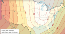
A point having a given latitude and longitude in NAD27 may be displaced on the order of many tens of meters from another point having the identical latitude and longitude in NAD83, so it is important to specify the datum along with the coordinates. The North American Datum of 1927 is defined by the latitude and longitude of an initial point (Meades Ranch Triangulation Station in Kansas), the direction of a line between this point and a specified second point, and two dimensions that define the spheroid. The North American Datum of 1983 is based on a newer defined spheroid (GRS 80); it is an Earth-centered (or "geocentric") datum having no initial point or initial direction.
North American Datum 1983 and WGS84
The initial definition of NAD83(1986) was intended to match GRS80 and WGS84, and many older publications indicate no difference. Subsequent more accurate measurements found a difference typically on the order of a meter over much of the United States. Each datum has undergone refinements with more accurate and later measurements.
One fundamental difference is that NAD83 is defined to remain essentially constant over time for points on the North American Plate, whereas WGS84 is defined with respect to the average of stations all over the world. Thus there is a change over time as to the difference between the systems. For much of the United States the relative rate is on the order of 1 to 2 cm per year.
Latest version of North American Datum
The United States National Spatial Reference System NAD 83(2011/MA11/PA11) epoch 2010.00, is a refinement of the NAD83 datum using data from a network of very accurate GPS receivers at Continuously Operating Reference Stations (CORS).
See also
References
- ↑ Shalowitz, USC&GS Field Engineers Bulletin, December 1938
- ↑ Craig, Cindy (October 2013) "Where Theory Meets Practice: United States Standard Datum" Professional Surveyor Magazine Frederick, Maryland
- ↑ US Coast & Geodetic Survey, "Triangulation in Kansas", Special Publication No. 70 (1921)
- ↑ Bulletin of the National Research Council, Issues 77-80, p. 230
- ↑ Van Zandt, Boundaries of the United States and the several states, p. 265
- ↑ Walter H. Schoewe, "Kansas and the geodetic datum of North America", Transactions of the Kansas Academy of Science 51 (1948) 117–124, www.jstor.org
- ↑ Cardarelli, Francois Encydopaedia of scientific units, weights, and measures: their SI equivalences and origins, Springer-Verlag London Limited 2003, ISBN 1-85233-682-X, page 5, table 2.1, data from Giacomo, P., Du platine a la lumiere, Bull. Bur. Nat. Metrologie, 102 (1995) 5–14.
External links
- NOAA-NGS-coordinates CORS-active network - explanation of NAD 83(2011/MA11/PA11) epoch 2010.00
- NOAA-NGS-coordinates passive network - explanation of most recent adjustment of passive network
- NADCON – a free utility for Microsoft Windows to convert between NAD27 and NAD83
- nadcon.prl – a web-based utility for NADCON
- NAD83: What Is It and Why You Should Care by Dane E. Ericksen, P.E., Hammett & Edison, Inc., Consulting Engineers. 1994 SBE National Convention and World Media Expo.