Land-use planning
Land-use planning is the general term used for a branch of urban planning encompassing various disciplines which seek to order and regulate land use in an efficient and ethical way, thus preventing land-use conflicts. Governments use land-use planning to manage the development of land within their jurisdictions. In doing so, the governmental unit can plan for the needs of the community while safeguarding natural resources. To this end, it is the systematic assessment of land and water potential, alternatives for land use, and economic and social conditions in order to select and adopt the best land-use options.[1] Often one element of a comprehensive plan, a land-use plan provides a vision for the future possibilities of development in neighborhoods, districts, cities, or any defined planning area.
In the United States, the terms land-use planning, regional planning, urban planning, and urban design are often used interchangeably, and will depend on the state, county, and/or project in question. Despite confusing nomenclature, the essential function of land-use planning remains the same whatever term is applied. The Canadian Institute of Planners offers a definition that land-use planning means the scientific, aesthetic, and orderly disposition of land, resources, facilities and services with a view to securing the physical, economic and social efficiency, health and well-being of urban and rural communities.[2] The American Planning Association states that the goal of land-use planning is to further the welfare of people and their communities by creating convenient, equitable, healthful, efficient, and attractive environments for present and future generations.[3]
History
Land-use planning often leads to land-use regulation, which typically encompasses zoning. Zoning regulates the types of activities that can be accommodated on a given piece of land, as well as the amount of space devoted to those activities, and the ways that buildings may be situated and shaped.[4]
The ambiguous nature of the term “planning”, as it relates to land use, is historically tied to the practice of zoning. Zoning in the US came about in the late 19th and early 20th centuries to protect the interests of property owners. The practice was found to be constitutionally sound by the Supreme Court decision of Village of Euclid v. Ambler Realty Co. in 1926.[3] Soon after, the Standard State Zoning Enabling Act gave authority to the states to regulate land use. Even so, the practice remains controversial today.
The “taking clause” of the Fifth Amendment to the United States Constitution prohibits the government from taking private property for public use without just compensation. The case of Dolan v. City of Tigard demonstrated the criteria that determine the threshold of what is considered taking.[5] One interpretation of the taking clause is that any restriction on the development potential of land through zoning regulation is a “taking”. A deep-rooted anti-zoning sentiment exists in America, that no one has the right to tell another what he can or cannot do with his land. Ironically, although people are often averse to being told how to develop their own land, they tend to expect the government to intervene when a proposed land use is undesirable.
Conventional zoning has not typically regarded the manner in which buildings relate to one another or the public spaces around them, but rather has provided a pragmatic system for mapping jurisdictions according to permitted land use. This system, combined with the interstate highway system, widespread availability of mortgage loans, growth in the automobile industry, and the over-all post-World War II economic expansion, destroyed most of the character that gave distinctiveness to American cities. The urban sprawl that most US cities began to experience in the mid-twentieth century was, in part, created by a flat approach to land-use regulations. Zoning without planning created unnecessarily exclusive zones. Thoughtless mapping of these zones over large areas was a big part of the recipe for suburban sprawl.[4] It was from the deficiencies of this practice that land-use planning developed, to envision the changes that development would cause and mitigate the negative effects of such change.

As America grew and sprawl was rampant, the much-loved America of the older towns, cities, or streetcar suburbs essentially became illegal through zoning.[6] Unparalleled growth and unregulated development changed the look and feel of landscapes and communities. They strained commercial corridors and affected housing prices, causing citizens to fear a decline in the social, economic and environmental attributes that defined their quality of life.[7] Zoning regulations became politically contentious as developers, legislators, and citizens struggled over altering zoning maps in a way that was acceptable to all parties. Land use planning practices evolved as an attempt to overcome these challenges. It engages citizens and policy-makers to plan for development with more intention, foresight, and community focus than had been previously used.
Types of planning
Various types of planning have emerged over the course of the 20th century. Below are the six main typologies of planning, as defined by David Walters in his book, Designing Communities (2007):
- Traditional or comprehensive planning: Common in the US after World War II, characterized by politically neutral experts with a rational view of the new urban development. Focused on producing clear statements about the form and content of new development.
- Systems planning: 1950s–1970s, resulting from the failure of comprehensive planning to deal with the unforeseen growth of post World War II America. More analytical view of the planning area as a set of complex processes, less interested in a physical plan.
- Democratic planning: 1960s. Result of societal loosening of class and race barriers. Gave more citizens a voice in planning for future of community.
- Advocacy and equity planning: 1960s & 70s. Strands of democratic planning that sought specifically to address social issues of inequality and injustice in community planning.
- Strategic planning: 1960s-present. Recognizes small-scale objectives and pragmatic real-world constraints.
- Environmental planning: 1960s-present. Developed as many of the ecological and social implications of global development were first widely understood.[6]
Today, successful planning involves a balanced mix of analysis of the existing conditions and constraints; extensive public engagement; practical planning and design; and financially and politically feasible strategies for implementation.[7]
Current processes include a combination of strategic and environmental planning. It is becoming more widely understood that any sector of land has a certain capacity for supporting human, animal, and vegetative life in harmony, and that upsetting this balance has dire consequences on the environment. Planners and citizens often take on an advocacy role during the planning process in an attempt to influence public policy.[6] Due to a host of political and economic factors, governments are slow to adopt land use policies that are congruent with scientific data supporting more environmentally sensitive regulations.
Smart Growth: Since the 1990s, the activist/environmentalist approach to planning has grown into the Smart Growth movement, characterized by the focus on more sustainable and less environmentally damaging forms of development.[6]
Smart growth supports the integration of mixed land uses into communities as a critical component of achieving better places to live. Putting uses in close proximity to one another has benefits for transportation alternatives to driving, security, community cohesiveness, local economies, and general quality of life issues. Smart growth strives to provide a means for communities to alter the planning context which currently renders mixed land uses illegal in most of the country.[9]
Methods
Professional planners work in the public sector for governmental and non-profit agencies, and in the private sector for businesses related to land, community, and economic development. Through research, design, and analysis of data, a planner's work is to create a plan for some aspect of a community. This process typically involves gathering public input to develop the vision and goals for the community.
A charrette is a facilitated planning workshop often used by professional planners to gather information from their clients and the public about the project at hand. Charettes involve a diverse set of stakeholders in the planning process, to ensure that the final plan comprehensively addresses the study area.
Geographic Information Systems, or GIS, is a very useful and important tool in land-use planning. It uses aerial photography to show land parcels, topography, street names, and other pertinent information. GIS systems contain layers of graphic information and their relational databases that may be projected into maps that allow the user to view a composite of a specific area, adding an array of graphically oriented decision making tools to the planning process.[7]
A transect, as used in planning, is a hierarchical scale of environmental zones that define a land area by its character, ranging from rural, preserved land to urban centers. As a planning methodology, the transect is used as a tool for managing growth and sustainability by planning land use around the physical character of the land. This allows a community to plan for growth while preserving the natural and historical nature of their environment.[7]
Basis of United States Land Use Planning Authority
The police power is the basis for land use planning authority in the United States. This authority is usually delegated by state governments to local governments, including counties and cities. It is these local governments that most frequently exercise police power in land use planning matters. The regulation of land use based on police power is distinct from the taking of private property by the government through the power of eminent domain. If the regulation of land use is done under the authority of the police power, the private property owner isn't typically entitled to compensation as they would be if property was taken under the power of eminent domain. The court decision in the case Commonwealth v. Alger was related to land use planning and dealt with the construction of a wharf on privately owned tidelands around Boston Harbor.[10]
See also
- Environmental planning
- Federal Land Use Policy Act of 1976
- Geographic Information Systems
- Inter-municipal land use planning
- Landscape architecture
- Landscape planning
- Regional planning
- Smart growth
- Spatial planning
- Sustainable development
- Transportation planning
- Urban design
- Urban planning
- Village Development Committee (India)
Academic journals
- Environment and Planning
- Land Use Policy
- Journal of Land Use and Environmental Law
- Journal of the American Planning Association
- Planning Theory
References
Notes
- ↑ Young, A., 2003
- ↑ Canadian Institute of Planners, 2011
- 1 2 American Planning Association, 2011
- 1 2 Barnett, J., 2004
- ↑ Martha Derthick. Dilemmas of Scale in America's Federal Democracy. p. 257.
- 1 2 3 4 Walters, D., 2007
- 1 2 3 4 Southwestern NC Planning and Economic Development Commission, Community Foundation of WNC, & the Lawrence Group Architects of NC, Inc., 2009
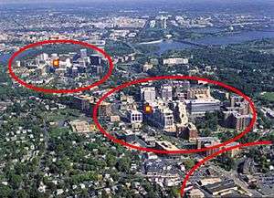
- ↑ "Arlington County, Virginia - National Award for Smart Growth Achievement - 2002 Winners Presentation | Smart Growth | US EPA". Epa.gov. 2006-06-28. Retrieved 2012-12-30.
- ↑ Smart Growth Network, 2011
- ↑ Understanding the Law of Zoning and Land Use Controls, Barlow Burke, Lexisnexis, Chapter 1, Published 2002
Bibliography
- Barnet, J. (2004). Codifying New Urbanism: How to Reform Municipal Land Development Regulations, Chicago, IL.
- Southwestern NC Planning and Economic Development Commission, Community Foundation of WNC, & the Lawrence Group Architects of NC, Inc. (2009). Region A Toolbox, A Pilot of the Mountain Landscapes Initiative, Sylva, NC.
- Walters, David. (2007). Designing Community, Charrettes, Master plans and Form-based Codes, Oxford, UK.
- Young, Anthony. (1993). Guidelines for Land Use Planning, Food and Agriculture Organization of the United Nations, Rome, Italy.
External links
- American Planning Association, Chicago, IL
- "Planning Is ...", Canadian Institute of Planners, Ottawa, ON
- Smart Growth Online, National Center for Appropriate Technology, Butte, MT
- "Arlington County, Virginia", U.S. Environmental Protection Agency, Washington, DC
- "An overview of spatial policy in Asian and European countries", Ministry of Land, Infrastructure, Transport and Tourism (MILT), Japan
| General | |||||||||||||||||||||||
|---|---|---|---|---|---|---|---|---|---|---|---|---|---|---|---|---|---|---|---|---|---|---|---|
| Major branches |
| ||||||||||||||||||||||
| Concepts/ theories | |||||||||||||||||||||||
| People |
| ||||||||||||||||||||||
| Related disciplines | |||||||||||||||||||||||
| Fields | 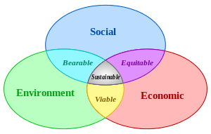 | |
|---|---|---|
| Related |
| |
| Applied |
| |
| ||
| Air |
|  | ||||||
|---|---|---|---|---|---|---|---|---|
| Energy | ||||||||
| Land | ||||||||
| Life | ||||||||
| Water |
| |||||||
| Related |
| |||||||
| ||||||||
| ||||||||