North Carolina Highway 147
| ||||
|---|---|---|---|---|
 | ||||
| Route information | ||||
| Maintained by NCDOT | ||||
| Length: | 15.7 mi[1] (25.3 km) | |||
| Existed: | 1987 – present | |||
| Major junctions | ||||
| South end: |
| |||
|
| ||||
| North end: |
| |||
| Location | ||||
| Counties: | Wake, Durham | |||
| Highway system | ||||
| ||||

North Carolina Highway 147 (NC 147) is a North Carolina state highway. The route is a 15.7-mile-long (25.3 km) freeway that connects the Research Triangle Park to both Western Wake County and the city of Durham. The section north of I-40 is known as the Durham Freeway, while the section south of I-40 is part of the Triangle Expressway.
Route description
The route's entire length is a limited access freeway; linking NC 540 in Morrisville with the Research Triangle Park (RTP), Downtown Durham and Interstates 40 and 85. It is a fairly urbanized commuter-route and suffers from peak-traffic during conventional rush hours. Speed limits on the freeway range from 55 mph (89 km/h) to 65 mph (105 km/h).
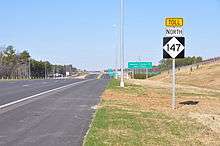
From NC 540 to Interstate 40, the highway is a toll road, part of the Triangle Expressway. Tolling on this stretch of NC 147 began on January 3, 2012.[2][3]
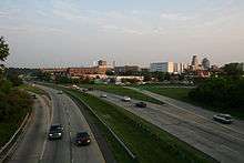
From I-40 to its northern terminus, the route is known as the Durham Freeway, and serves as the primary artery through the Research Triangle Park and Downtown Durham. The Durham Freeway portion was originally envisioned as an alignment of Interstate 40, though the interstate was built to the south of the city center instead. The Durham Freeway received the NC-147 designation in 1986. From I-40 through the Research Triangle Park, to the Briggs Avenue exit the freeway goes primarily north-south, with wide medians and shoulders and interstate-grade entrance and exit ramps. Entering Downtown Durham past Briggs Avenue, the road turns towards a more northeast-southwest alignment, and narrows considerably, with narrow medians and shoulders, and short entrance and exit ramps, following a depressed road cut to the south of Downtown Durham, passing several major landmarks including the Durham Bulls Athletic Park (visible to the north of the roadway), the Durham Performing Arts Center, and the American Tobacco Historic District. Past Downtown Durham, the freeway passes through Duke University, forming the boundary between East Campus and Central Campus.
Past Duke University, the road reaches its northern terminus in a complex interchange with the U.S. 15-501 Freeway and Interstate 85. Motorists must use U.S. 15-501 for access between I-85 south and NC 147 south, or between NC 147 north and I-85 north. At the actual northern terminus, traffic on NC 147 north merges with I-85 south, while I-85 north traffic can enter NC 147 south using exit 172.
Dedicated and memorial names
NC 147 features one dedicated stretch of freeway. The Buck Dean Expressway is the official name of NC 147 within the city limits of Durham that was approved on December 14, 1984.[4]
Tolls
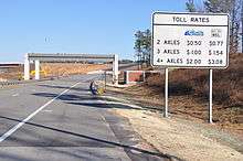
Tolls along NC 147 are done by electronic toll collection (ETC) and are enforced by video cameras. Several gantries are located along the route and entrance/exit ramps, where they collect toll via the NC Quick Pass or other interoperable ETC systems. Those that do not participate in the ETC program will receive a bill in the mail and will have 30 days from date on bill before additional fees and civil penalties are applied.[5]
History
The Durham Freeway began with a 1962 bond referendum.[6] The first section of the road, completed in 1970 around downtown Durham, extended from Chapel Hill Street to Alston Avenue and resulted in the destruction of a portion of the Hayti neighborhood as part of urban renewal,[7] though a DOT engineer said the neighborhood likely would have been torn down anyway. The road was later extended west to Erwin Road and southward to where it meets I-40. In 1986, The freeway was designated as North Carolina Highway 147. The road's other names have included East-West Expressway and the I.L. "Buck" Dean Freeway.[6]
In 1979, planners said many of the city's roads needed widening, and the decision was made to extend the freeway to I-85. The first section in 1982 disrupted the Crest Street neighborhood, but the N.C. DOT moved 181 houses instead of tearing them down, an action that resulted in a 1987 third-place Federal Highway Administration award for "historic preservation and cultural enhancement".[6] Eventually, the problems that caused the original I-40 extension to I-85 to be delayed were overcome, and NC 147 was extended through the city. Work began in 1993, and the eastbound lanes opened May 21, 1997.[8] The section connecting the road to I-85 opened July 31, 1998.[7]
On September 6, 2011, the south termini at T.W. Alexander Drive (exit 4) was permanently closed to make way for NC 147's extension to NC 540 in Morrisville; this made I-40 the temporary southern termini for three months. On December 8, 2011, the southern extension was opened. Dubbed the Triangle Parkway, the 3.4-mile (5.5 km) stretch of road is also part of the Triangle Expressway.[2][3][9][10]
Future
There is one current and one future project involving NC 147. The first is the East End Connector which began construction in March 2015.[11] This project, which will build a direct freeway connection designed to interstate standards between the Durham Freeway and north of the U.S. 70/N.C. 98, and which has been delayed many times, is now scheduled to be completed by July 2019.[12] The proposed future project is the NC 147 extension to McCrimmon Parkway, in Morrisville, which is scheduled for Reprioritization.[13][14]
Junction list
| County | Location | mi[1] | km | Exit | Destinations | Notes |
|---|---|---|---|---|---|---|
| Wake | Morrisville | McCrimmon Parkway | Proposed extension (unfunded)[13][14] | |||
| 1.5 | 2.4 | 1 | Southbound exit left; Triangle Expressway continues NC 540 south | |||
| Durham | RTP | 2.5 | 4.0 | 2 / 3 | Davis Drive / Hopson Road | Signed exit 2 northbound, exit 3 southbound |
| 4 | T.W. Alexander Drive | Permanently closed as of September 6, 2011[9][10] | ||||
| 4.5 | 7.2 | 5 | Triangle Expressway begins; signed as exit 5A (east) and 5B (west) | |||
| 5.5 | 8.9 | 6 | Cornwallis Road – Research Triangle Park | |||
| 6.5 | 10.5 | 7 | T.W. Alexander Drive | |||
| 7.5 | 12.1 | 8 | Ellis Road | |||
| Durham | 9 | East End Connector (under construction)[11][15] | ||||
| 10.5 | 16.9 | 10 | Briggs Avenue – Durham Technical Community College | |||
| 11.3 | 18.2 | 11 | ||||
| 11.8 | 19.0 | 12A | Fayetteville Street – North Carolina Central University | |||
| 12.0 | 19.3 | 12B | To Durham Bulls Athletic Park | |||
| 12.6 | 20.3 | 12C | Duke Street | No southbound exit; To North Carolina Museum of Life and Science | ||
| 13.0 | 20.9 | 13 | Chapel Hill Street | |||
| 13.7 | 22.0 | 14 | To North Carolina School of Science and Mathematics and Northgate Mall | |||
| 14.3 | 23.0 | 15A | Elba Street / Trent Drive | Northbound exit, southbound entrance; to Duke Medical Center | ||
| 14.8 | 23.8 | 15B | Hillandale Road / Fulton Street | To Veterans Affairs Medical Center | ||
| 15.7 | 25.3 | 16 | Signed as exits 16A (north) and 16B (south) | |||
| 17.2 | 27.7 | Northbound exit, southbound entrance | ||||
1.000 mi = 1.609 km; 1.000 km = 0.621 mi
| ||||||
Interstate 885
| |
|---|---|
| Location: | Durham, North Carolina |
Interstate 885 (I-885) is the proposed designation traversing between I-40 and I-85/US 15, in Durham and the RTP area. Its appearance was released on August 19, 2014 when the October project letting was released, which included I-885 in the sign plans. NCDOT also listed in the documentation that fabrication of the signs cannot proceed until approval of the route is completed via FHWA; thus this routing is, for now, a proposal.[11][15]
If approved and designated, the interstate would begin at the I-40/NC 147 interchange (exit 279) then go north in concurrency with NC 147 to the East End Connector, where it will switch to US 70. Continuing north in concurrency with US 70, it ends at the I-85/US 15/US 70 interchange (exit 178). The existing exit numbers now on NC 147 and US 70 would be replaced by I-885.
No official request has been submitted to AASHTO or FHWA; this route is currently proposed by NCDOT and is subject to change. The East End Connector is slated to be completed by July 2019.[16]
References
- 1 2 Google (December 13, 2012). "North Carolina Highway 147" (Map). Google Maps. Google. Retrieved December 13, 2012.
- 1 2 "Triangle Expressway". North Carolina Turnpike Authority. Retrieved December 8, 2011.
- 1 2 "State's First Modern Toll Road Opens Today". The News & Observer. Raleigh, NC. December 8, 2011. Retrieved December 8, 2011.
- ↑ "North Carolina Memorial Highways and other Named Facilities" (PDF). North Carolina Department of Transportation. Archived from the original (PDF) on December 29, 2012. Retrieved June 19, 2011.
- ↑ "NC Quick Pass FAQs". North Carolina Turnpike Authority. Retrieved April 13, 2014.
- 1 2 3 Bloom, Jonathan (July 26, 1998). "30-Year, 12-Mile Project Completed". The Herald-Sun. Durham, NC. p. A1.
- 1 2 Bloom, Jonathan (August 1, 1998). "Durham Freeway's Last Leg Opens". The Herald-Sun. Durham, NC. p. A8.
- ↑ "Durham Freeway's New Lanes to Ease Eastbound Travel". The Herald-Sun. Durham, NC. May 21, 1997. p. C1.
- 1 2 "Section of N.C. 147 in Durham to Close Sept. 6" (Press release). North Carolina Department of Transportation. Retrieved August 19, 2011.
- 1 2 "Crosstown Traffic—RTP Commuters: The NC 147 Southern Spur Is Closed Today, for Good". The News & Observer. Raleigh, NC. September 6, 2011. Retrieved September 6, 2011.
- 1 2 3 "East End Connector". North Carolina Department of Transportation. Retrieved May 30, 2015.
- ↑ "Work to Begin on East End Connector Project". North Carolina Department of Transportation. Retrieved May 30, 2015.
- 1 2 Staff. "Project #U-4763". Project Details. North Carolina Department of Transportation. Retrieved December 13, 2012.
- 1 2 Staff. "Project #U-4763A". Project Details. North Carolina Department of Transportation. Retrieved December 13, 2012.
- 1 2 "Signing Plan, Durham County, T.I.P.: U-0071" (PDF). North Carolina Department of Transportation. Retrieved August 19, 2014.
- ↑ Siceloff, Bruce (September 8, 2014). "Road Worrier: Durham's East End Connector Spawns an 8-Mile Interstate". The News & Observer. Raleigh, NC. Retrieved September 9, 2014.
External links
| Wikimedia Commons has media related to North Carolina Highway 147. |
| ||