Nalagarh
| Nalagarh Hindur | |
|---|---|
|
View of city from the Palace/Heritage Resort Nalagarh | |
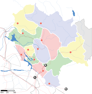  Location in Himachal Pradesh, India | |
| Coordinates: 31°03′N 76°43′E / 31.05°N 76.72°ECoordinates: 31°03′N 76°43′E / 31.05°N 76.72°E | |
| Country |
|
| State | Himachal Pradesh |
| Languages | |
| • Official | Hindi |
| Time zone | IST (UTC+5:30) |
| Vehicle registration | HP-12,HP-64 |

Nalagarh is a city and a municipal committee in Solan district in the Indian state of Himachal Pradesh. It was the seat of the eponymous princely state during the British Raj, and known in medieval period as the state of Hindur. It was founded by the Chandella Rajputs in 1100 AD. At present Nalagarh is an emerging town for industries as it hosts production units for leather, steel, chemicals, thread mills and breweries; thus air pollution is quite a concern here. It is situated at 65 km distance from nearby major city Chandigarh. It has further been reduced to about 40 km after the opening of Chandigarh Siswan road.
History
Nalagarh is a gateway to Himachal Pradesh in North India, 300 km of north Delhi and 60 km from Chandigarh. The Fort which was built in 1421 during the reign of Raja Bikram Chand is located on a hillock at the foothills of the mighty Himalayas affording a panoramic view of the Shivalik hills beyond the Sirsa river.
In the early twentieth century, Nalagarh State was one of the Simla hill states, under the government of the Punjab.[1] The country was overrun by the Gurkhas for some years before 1815, when they were driven out by the British, and the raja was confirmed in possession of the territory. Grain and opium have, in the past, been main agricultural products.
Nalagarh was ruled by the Chandela Rajputs who originated from Chanderi in the Bundelkhand region of central India. Various other rajputs then inhabited this place including Thakurs, Tomara, Rathore, Parmar, Pawar, Panwar, Chauhan, Bais. Many have now stayed back as farmers in the Chikni Sirsa Valley
Fort Nalagarh surrounded by endless acres of greenery, with all modern amenities is an ideal retreat away from the madding crowd of metropolitan cities.
Palace/Fort
Being the princely state in pre Independence period Nalagarh has few historical buildings.It still has a Palace/fort which is now converted into the heritage resort.Its building is maintained in original form.Fort Nalagarh surrounded by endless acres of greenery, with all modern amenities is an ideal retreat away from the madding crowd of metropolitan cities.
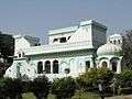 view of palace
 view of palace
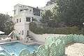 swimming pool of palace
 Architecture of Nalagarh Palace
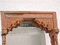 Wooden art work of Nalagarh Palace
See also
Politics
Currently Er. K.L. Thakur is the M.L.A.(B.J.P.) of Nalagarh constituency and district president of BJP Solan who won by a huge margin of 9308 votes defeating congress candidate Shri Lakhwinder Rana in the assembly elections whose results were declared on 20 December 2012. During General Elections of 2014, BJP Candidate got highest lead i.e of 17,526 votes from Nalagarh.
Tek Chand Chandel is current president of Bhartiya Janta Party Nalagarh and Aseem Sharma is President for Indian National Congress Nalagarh.
Saurabh Dhiman is serving as President of Youth Wing of Bhartiya Janta Party and Prince Sharma is serving as President of Youth Wing of Indian National Congress from Nalagarh constituency.
Geography
Nalagarh is a Semi Hilly Area. While the summers are hot and dry Winters are Dry and wet. Summers temperature does reach 45 degrees Celsius, also it could be Humid, Which Make "Feel Temperature" at 50 degrees Celsius. During rainy season strong winds are experienced. Yet Nalagarh Physically belongs to Himachal Pradesh but Look and feel of it is mostly like Punjab.More than 80% people are Punjabi. It is a town Which is close to Pinjore in Haryana, to Ropar in Punjab. The averrage annual rainfall is 600mm. During the year 2007 it has gone up to 1250mm. The soil strata contains mixed layers of clay soil, river pebbles and coarse sand in layers of 2m to 3m.
Demographics
As of 2001 India census,[2] Nalagarh had a population of 9433. Males constitute 54% of the population and females 46%. Nalagarh has an average literacy rate of 76%, higher than the national average of 59.5%: male literacy is 80%, and female literacy is 72%. In Nalagarh, 12% of the population is under 6 years of age. Language spoken here is mainly Punjabi.Nalgarh is a municipal council which have 9 wards.Nalagarh area touches the areas of Ropar and Anandpur Sahib of Punjab.
In the 1961 Census of India, 60.2% of the Nalagarh tehsil of the then Ambala district registered their language as Hindi and 14.8% registered it as Punjabi.
| Rank | Language | 1961 census[3] |
|---|---|---|
| 1 | Hindi | 78.4% |
| 2 | Punjabi | 14.8% |
| 3 | Pahari | 6.4% |
| 4 | Other | 0.4% |
Industrialization
Nalagarh is an industrial area with many variety of industries, as nearby grown industry area Baddi is over flowing. Some of the major industries are GPI textiles,Drish, Godrej Hershey Ltd, TVS Motors Sara textiles etc. The full list of Industries including baddi & barotiwala region can be found on Nalagarh Industrial Directory http://www.industrialhelpline.com/ .Bal Vidya Niketan is oldest school in region. They are serving BBN since 1978. Nalagarh has 5 CBSE schools and soon it will also have ICSE school. The school with the highest strength is Alpine Public School, Nalagarh, Himachal Pradesh . It is the 1st CBSE affiliated school in Nalagarh region. Apart from it there are other schools like GuruNanak Public School, Doon Valley Public School, Govt. Sr. Sec. School, etc.
References
- ↑ https://books.google.co.in/books?id=ayYbAvECXQwC&pg=PA254&lpg=PA254&dq=The+Princely+House+Of+Nalagarh&source=bl&ots=08cGcBDEzo&sig=EgI0_5A6vzcQaiAUXxSL3ftVw5o&hl=en&sa=X&ved=0ahUKEwjan5yYqPXOAhXCOY8KHZnXBGgQ6AEIHDAA#v=onepage&q=The%20Princely%20House%20Of%20Nalagarh&f=false
- ↑ "Census of India 2001: Data from the 2001 Census, including cities, villages and towns (Provisional)". Census Commission of India. Archived from the original on 2004-06-16. Retrieved 2008-11-01.
- ↑ http://14.139.60.114:8080/jspui/bitstream/123456789/955/8/Pathankot%20Tehsil%20(25-46).pdf
External links
- Genealogy of the ruling chiefs of Nalagarh
- About Nalagarh Fort
- Raja VIJAYENDRA SINGH
- NALAGARH
- Baddi, Barotiwala, Nalagarh Industrial Directory