National Register of Historic Places listings in Lapeer County, Michigan

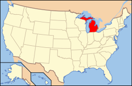
The following is a list of National Register of Historic Places listings in Lapeer County, Michigan. Lapeer County was founded in 1822 and has a current estimated population of almost 90,000. It is officially listed as part of Metro Detroit with Lapeer as a county seat.
The county currently contains 24 properties listed on the National Register of Historic Places. All 24 of these sites are also listed as Michigan State Historic Sites, in which the county contains 43 such state listed properties.[1] The listings on the National Register include 15 houses, four historic districts, one former train station, former courthouse, a bank, a mill, and the restricted Younge Site. The Warren Perry house has since been moved from its original location. The city of Lapeer has the most listings with 13.
- This National Park Service list is complete through NPS recent listings posted December 2, 2016.[2]
Current listings
| [3] | Name on the Register | Image | Date listed[4] | Location | City or town | Description |
|---|---|---|---|---|---|---|
| 1 | Joseph Armstrong House | 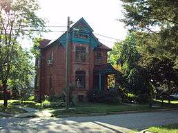 |
(#85001625) |
707 Monroe Street 43°03′20″N 83°18′58″W / 43.055556°N 83.316111°W |
Lapeer | Built in 1887–1888, the 2½-story house was built for prominent local businessman Joseph Armstrong, who operated a dry goods store in Lapeer for 37 years. The house has undergone few alterations since its original construction. |
| 2 | Currier House | 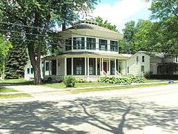 |
(#75000950) |
231 East Saint Clair Street 42°55′15″N 83°02′31″W / 42.920833°N 83.041944°W |
Almont | Built in 1854, this octagon house was built by Frederick Currey, who was a prominent businessman in Lapeer County. The front, rear, and side walls are 24 feet (7.3 m) long, and the four diagonal walls are six feet (1.8 m) in length. |
| 3 | John W. Day House | 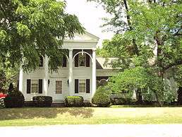 |
(#87002153) |
4985 Dryden Road 42°56′44″N 83°08′43″W / 42.945556°N 83.145278°W |
Dryden Township | Built in 1863, the structure is a wood framed, two-story Greek Revival house built for farmer John W. Day and later purchased by Augustus Dittman in 1870. The house has undergone a few additions, including the entire right side wing in 1880. |
| 4 | Detroit–Bay City Railroad Company Columbiaville Depot | Upload image | (#84001785) |
4643 First Street 43°09′22″N 83°24′32″W / 43.156111°N 83.408889°W |
Columbiaville | The former train station functioned from 1893–1964 and was a prominent stopover to and from Detroit and Bay City. It was built by William Peter, who platted Columbiaville in 1871. Decommissioned in 1964, the railway itself ceased operation in 1977. |
| 5 | Dryden Community Country Club–General Squier Historic Park Complex | 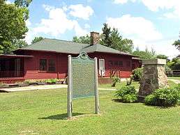 |
(#86001220) |
4725 South Mill Road 42°55′33″N 83°07′27″W / 42.925833°N 83.124167°W |
Dryden Township | Comprising 80 acres (33 ha), the oldest structure on the site is a mill dating to 1871. The complex, which also contains a water park and several other structures, served as the summer residence of George Owen Squier who later converted his property into a county park. |
| 6 | James B. Dutton House |  |
(#85001626) |
605 Calhoun Street 43°03′18″N 83°18′54″W / 43.055°N 83.315°W |
Lapeer | |
| 7 | James F. Fairweather–Jacob C. Lamb House |  |
(#85002494) |
540 South Almont Avenue 43°01′07″N 83°04′39″W / 43.018611°N 83.0775°W |
Imlay City | |
| 8 | Hadley Flour and Feed Mill | 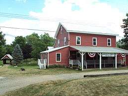 |
(#86002770) |
3633 Hadley Road 42°57′03″N 83°24′11″W / 42.950833°N 83.403056°W |
Hadley Township | The site includes several structures, but the main building is a 2½ story wooden gristmill constructed in 1874. The site ceased operation in 1964 and was later converted to a museum known as the Hadley Mill Museum that was donated to the township in 2002. |
| 9 | Rodney G. Hart House |  |
(#85001627) |
326 West Park Street 43°03′19″N 83°18′44″W / 43.055278°N 83.312222°W |
Lapeer | |
| 10 | John and Julia Hevener House |  |
(#85001628) |
1444 West Genesee Street 43°03′03″N 83°19′22″W / 43.050833°N 83.322778°W |
Lapeer | |
| 11 | Lapeer County Courthouse | 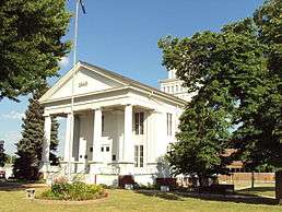 |
(#71000402) |
Courthouse Square, West Nepessing Street 43°03′14″N 83°18′39″W / 43.053889°N 83.310833°W |
Lapeer | Completed in 1846, the Greek Revival courthouse is recognized as the oldest original courthouse still in use in the state of Michigan and one of the 10 oldest such structures in all of the country. It has remained largely unaltered since it was built and continues to serve the county. |
| 12 | John and Rosetta Lee House | 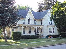 |
(#85001629) |
823 Calhoun Street 43°03′25″N 83°18′55″W / 43.056944°N 83.315278°W |
Lapeer | Built in 1872, it is one of the few Gothic Revival houses in Lapeer. At some point, it was converted from a single dwelling into an apartment house, which was the biggest structural change to the building, but most of the exterior has remained the same. |
| 13 | Metamora Crossroads Historic District | 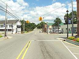 |
(#84001790) |
Intersection of Oak and High Street 42°56′30″N 83°17′20″W / 42.941667°N 83.288889°W |
Metamora | Consisting of 15 buildings dating from 1850–1910, the 3.5 acre (1.4 ha) district centers on Oak and High Street in the village of Metamora, which dates back to 1838. Development of this core area ceased prior to World War I, preserving the early architecture. |
| 14 | Charles Palmer House |  |
(#87000916) |
240 North Main Street 43°01′34″N 83°04′28″W / 43.026111°N 83.074444°W |
Imlay City | |
| 15 | Warren Perry House |  |
(#85001630) |
892 Saginaw Street moved to1497 W. Genesee Street 43°02′24″N 83°18′15″W / 43.04°N 83.304167°W |
Lapeer | |
| 16 | Piety Hill Historic District | 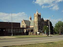 |
(#85001631) |
Bounded by Park, Calhoun, Nepressing, Cramton, and Main[5] 43°03′09″N 83°19′00″W / 43.0525°N 83.316667°W |
Lapeer | As the center of Lapeer's early religious gatherings and the oldest platted section of the city, it includes five different church structures dating from 1881–1911. The majority of properties in the district are single-family dwellings dating from 1830–1850. |
| 17 | Pioneer State Bank No. 36 | 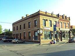 |
(#82002846) |
4046 Huron Street 43°13′45″N 83°11′36″W / 43.229167°N 83.193333°W |
North Branch | Built in 1906, the building is the oldest bank institution in North Branch. Founded in 1885 as a state bank and reorganized in 1889, the present site was purchased for a new building in 1903. The structure continues to operate as an independent bank. |
| 18 | Samuel J. Tomlinson House |  |
(#85001632) |
841 Calhoun Street 43°03′26″N 83°18′55″W / 43.057222°N 83.315278°W |
Lapeer | |
| 19 | Columbus Tuttle House |  |
(#85001633) |
610 North Main Street 43°03′18″N 83°19′07″W / 43.055°N 83.318611°W |
Lapeer | |
| 20 | Peter Van Dyke House |  |
(#85001634) |
1091 Pine St. 43°03′34″N 83°18′44″W / 43.059444°N 83.312222°W |
Lapeer | |
| 21 | William H. and Sabrina Watson House |  |
(#85001635) |
507 Cedar Street 43°03′18″N 83°18′45″W / 43.055°N 83.3125°W |
Lapeer | |
| 22 | West Saint Clair Street Historic District | 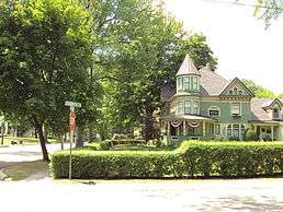 |
(#86000998) |
124–328 West Saint Clair Street 42°55′14″N 83°02′52″W / 42.920556°N 83.047778°W |
Almont | Consisting of 15 houses located along a single stretch of West Saint Clair Street, the district also contains the Henry Stephens Memorial Library, which is a contributing property that was listed in its own right as a Michigan State Historic Site on May 16, 1991. |
| 23 | Jay White House |  |
(#85001636) |
1109 West Genesee Street 43°03′02″N 83°19′14″W / 43.050556°N 83.320556°W |
Lapeer | |
| 24 | Younge Site | Upload image | (#76002161) |
Address Restricted |
Goodland Township | The Younge Site contains two wooden structures and a burial site presumed to belong to Native Americans in the 1600s. Archaeologists discovered unusual burying practices in the exhumed remains, including the drilling of the skulls and other bone modifications prior to burial. |
See also
| Wikimedia Commons has media related to National Register of Historic Places in Lapeer County, Michigan. |
- List of Michigan State Historic Sites in Lapeer County, Michigan
- National Register of Historic Places listings in Michigan
References
- ↑ State of Michigan (2009). "Historic Sites Online: Lapeer County". Retrieved July 5, 2010.
- ↑ "National Register of Historic Places: Weekly List Actions". National Park Service, United States Department of the Interior. Retrieved on December 2, 2016.
- ↑ Numbers represent an ordering by significant words. Various colorings, defined here, differentiate National Historic Landmarks and historic districts from other NRHP buildings, structures, sites or objects.
- ↑ The eight-digit number below each date is the number assigned to each location in the National Register Information System database, which can be viewed by clicking the number.
- ↑ The district is very irregularly shaped and includes assorted properties along the streets of Calhoun, Monroe, Madison, Washington, Main (M-24), Park, Liberty, Church, and Nepessing in the city of Lapeer. State of Michigan. "Piety Hill Historic District boundary map". Retrieved July 9, 2011.
