National Register of Historic Places listings in Mille Lacs County, Minnesota
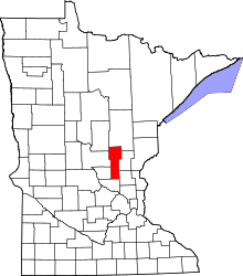
Location of Mille Lacs County in Minnesota
This is a list of the National Register of Historic Places listings in Mille Lacs County, Minnesota.
This is intended to be a complete list of the properties and districts on the National Register of Historic Places in Mille Lacs County, Minnesota, United States. The locations of National Register properties and districts for which the latitude and longitude coordinates are included below, may be seen in an online map.
There are 12 properties and districts listed on the National Register in the county, including one National Historic Landmark. Another property was once listed but has been removed.
- This National Park Service list is complete through NPS recent listings posted December 16, 2016.[1]
Current listings
| [2] | Name on the Register[3] | Image | Date listed[4] | Location | City or town | Description |
|---|---|---|---|---|---|---|
| 1 | Bridge No. 3355-Kathio Township | 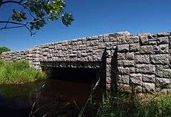 |
(#98000685) |
U.S. Route 169 over Whitefish Creek 46°12′55″N 93°47′34″W / 46.215298°N 93.792869°W |
Kathio Township | 1921 roadway with 1939 ornamental stonework by the Civilian Conservation Corps.[5] |
| 2 | Cooper Site | 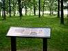 |
(#70000299) |
Elbow of Ogechie Lake within Mille Lacs Kathio State Park[6]:290 46°08′43″N 93°46′31″W / 46.145278°N 93.775222°W |
Onamia vicinity | Pre-Columbian habitation/mound site and historic-era Mdewakanton Dakota village site.[5] |
| 3 | Robert C. Dunn House | 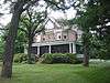 |
(#85001922) |
708 S. 4th St. 45°33′58″N 93°35′04″W / 45.56606°N 93.584395°W |
Princeton | 1902 brick Colonial Revival house of a newspaper publisher and Good Roads Movement advocate.[5] |
| 4 | Ephraim C. Gile House | 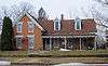 |
(#85001907) |
311 8th Ave., S. 45°33′57″N 93°35′06″W / 45.565936°N 93.585063°W |
Princeton | c. 1872 brick Gothic Revival house.[5] |
| 5 | Great Northern Depot | 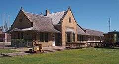 |
(#77000757) |
101 S 10th St. 45°34′09″N 93°35′17″W / 45.569222°N 93.587994°W |
Princeton | 1902 brick Queen Anne/Jacobean depot with sandstone trim. |
| 6 | Kathio Site | 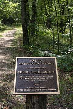 |
(#66000403) |
Within Mille Lacs Kathio State Park 46°07′45″N 93°45′15″W / 46.129174°N 93.754063°W |
Vineland vicinity | 19 identified archaeological sites ranging from 3000 BCE to 1750 CE. Now a state park.[7] |
| 7 | Milaca Municipal Hall |  |
(#85002201) |
145 Central Ave, S. 45°45′15″N 93°39′03″W / 45.754213°N 93.650883°W |
Milaca | 1936 fieldstone town hall with interior murals, built by the Works Progress Administration.[5] Now a local history museum.[8] |
| 8 | Mille Lacs County Courthouse | 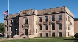 |
(#77000756) |
635 2nd St., SE. 45°45′15″N 93°38′35″W / 45.754297°N 93.643092°W |
Milaca | 1923 Renaissance/Classical Revival courthouse of Indiana Limestone.[5] |
| 9 | Onamia Municipal Hall | 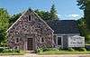 |
(#85002333) |
621 Main St. 46°04′13″N 93°40′08″W / 46.070415°N 93.668857°W |
Onamia | 1936 fieldstone town hall with Arts and Crafts elements, built by the Works Progress Administration.[5] |
| 10 | Petaga Point | 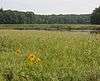 |
(#70000300) |
Southern end of Ogechie Lake at the source of the Rum River[6]:290 46°07′50″N 93°46′50″W / 46.130556°N 93.780556°W |
Onamia vicinity | 3000–1000 BCE habitation site, the oldest within the Kathio Site district.[5] |
| 11 | Saw Mill Site | 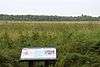 |
(#70000301) |
Mille Lacs Kathio State Park[9] Coordinates missing |
Onamia vicinity | 400–1600 CE village site.[5] |
| 12 | Vineland Bay Site | 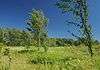 |
(#70000302) |
Shore of Vineland Bay immediately north of the Rum River[6]:318 46°09′45″N 93°45′22″W / 46.162556°N 93.756111°W |
Vineland vicinity | c. 800–1100 CE village site.[5] |
Former listing
| [2] | Name on the Register | Image | Date listed | Date removed | Location | City or town | Summary |
|---|---|---|---|---|---|---|---|
| 1 | Ellen Ruth (launch) | Upload image | (#85001923) | Main St. between Lake Shore Boulevard and Fifth St. (original address) Current coordinates are 46°07′05″N 93°31′15″W / 46.118129°N 93.520713°W |
Wahkon | Fishing boat brought in 1933 to serve an early lake resort.[10] Relocated in 1989.[5] |
See also
- List of National Historic Landmarks in Minnesota
- National Register of Historic Places listings in Minnesota
References
- ↑ "National Register of Historic Places: Weekly List Actions". National Park Service, United States Department of the Interior. Retrieved on December 16, 2016.
- 1 2 Numbers represent an ordering by significant words. Various colorings, defined here, differentiate National Historic Landmarks and historic districts from other NRHP buildings, structures, sites or objects.
- ↑ National Park Service (2008-04-24). "National Register Information System". National Register of Historic Places. National Park Service.
- ↑ The eight-digit number below each date is the number assigned to each location in the National Register Information System database, which can be viewed by clicking the number.
- 1 2 3 4 5 6 7 8 9 10 11 Nord, Mary Ann (2003). The National Register of Historic Places in Minnesota. Minnesota Historical Society. ISBN 0-87351-448-3.
- 1 2 3 Aufderheide, Arthur C., et al. "Health, Demography, and Archaeology of Mille Lacs Native American Mortuary Populations". Plains Anthropologist 39.149 (1994): 251-375.
- ↑ "Kathio Site". National Historic Landmarks Program. National Park Service. Retrieved 2012-08-26.
- ↑ "Milaca Area Historical Society". Retrieved 2013-02-25.
- ↑ Nord, Mary Ann (2003). The National Register of Historic Places in Minnesota. Minnesota Historical Society. ISBN 0-87351-448-3. The NRIS lists the site as "Address Restricted".
- ↑ "Area Information". North Star Resort. Retrieved 2013-02-26.
External links
| Wikimedia Commons has media related to National Register of Historic Places in Mille Lacs County, Minnesota. |
- Minnesota National Register Properties Database—Minnesota Historical Society

This article is issued from Wikipedia - version of the 9/15/2016. The text is available under the Creative Commons Attribution/Share Alike but additional terms may apply for the media files.