National Register of Historic Places listings in Morrison County, Minnesota
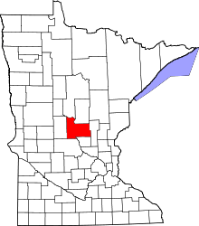
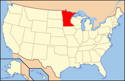
Location of Morrison County in Minnesota
This is a list of the National Register of Historic Places listings in Morrison County, Minnesota. It is intended to be a complete list of the properties and districts on the National Register of Historic Places in Morrison County, Minnesota, United States. The locations of National Register properties and districts for which the latitude and longitude coordinates are included below, may be seen in an online map.
There are 25 properties and districts listed on the National Register in the county, including one National Historic Landmark. A supplementary list includes two additional sites that were formerly on the National Register.
- This National Park Service list is complete through NPS recent listings posted December 16, 2016.[1]
Current listings
| [2] | Name on the Register | Image | Date listed[3] | Location | City or town | Description |
|---|---|---|---|---|---|---|
| 1 | Ayer Mission Site |  |
(#73000984) |
Address restricted[4] |
Belle Prairie Township | Site of an 1849 farmhouse and mission school.[5] |
| 2 | Belle Prairie Village Site | |
(#73000985) |
Address restricted[4] |
Belle Prairie Township | Precolumbian village site on the Mississippi River.[5] |
| 3 | Bridge No. 4969 | Upload image | (#14001175) |
TH 115 & BNSFRR over Mississippi R. 46°04′28″N 94°20′06″W / 46.0744°N 94.3349°W |
Camp Ripley vicinity | Minnesota's only unified road–rail bridge, built in 1930 as the key transportation connection for Camp Ripley, the state's first and most significant Minnesota National Guard reservation.[6] |
| 4 | Burton-Rosenmeier House | 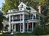 |
(#86000328) |
606 1st St., SE. 45°58′15″N 94°21′53″W / 45.970855°N 94.364586°W |
Little Falls | Little Falls' leading example of Neoclassical architecture, built c. 1900 and owned successively by notable local merchant Barney Burton and attorney/politician Christian Rosenmeier.[7] Now houses the Little Falls Convention and Visitors Bureau. |
| 5 | Church of Our Savior-Episcopal |  |
(#80002090) |
113 4th St., NE. 45°58′36″N 94°21′29″W / 45.976696°N 94.358004°W |
Little Falls | 1903 Tudor Revival church significant as a leading example of Minnesota's second generation of Episcopal churches.[8] |
| 6 | Crow Wing State Park | 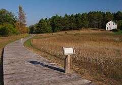 |
(#70000288) |
Off Minnesota Highway 371 46°16′39″N 94°20′40″W / 46.2775°N 94.344444°W |
Brainerd vicinity | Long-used site at a key travel junction associated with the Dakota/Ojibwe territorial conflict and the early town of Old Crow Wing, whose abandonment in the 1880s uniquely preserves the succession of the Native American, fur trade, and logging eras. Extends into Cass and Crow Wing Counties.[9] |
| 7 | Fort Duquesne (21-MO-20) | 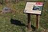 |
(#84000452) |
Address restricted 46°00′46″N 94°21′30″W / 46.012671°N 94.358305°W |
Little Falls vicinity | Site where explorer Joseph Marin de la Malgue wintered c. 1752.[5] |
| 8 | Fort Ripley | 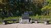 |
(#71000439) |
Off Minnesota Highway 115[10] 46°10′32″N 94°22′23″W / 46.175503°N 94.373149°W |
Camp Ripley Military Reservation | Site of an 1849 military post—the second ever built in Minnesota—to keep the peace among the Dakota, Ojibwe, and Ho-Chunk.[5] |
| 9 | Charles A. Lindbergh House and Park | 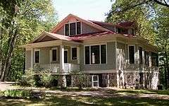 |
(#70000303) |
1620 Lindbergh Dr. S. 45°57′29″N 94°23′16″W / 45.958043°N 94.387863°W |
Little Falls vicinity | 1907 house and farm of Congressman Charles August Lindbergh and his son, aviator Charles Lindbergh.[11] Now a state park and Minnesota Historical Society site.[12] |
| 10 | Charles A. Lindbergh State Park WPA/Rustic Style Historic Resources |  |
(#89001655) |
Off County Highway 52, south of Little Falls 45°57′27″N 94°23′25″W / 45.957624°N 94.390406°W |
Little Falls vicinity | Park facilities significant as examples of New Deal federal work relief, state park development, and National Park Service rustic design, with six contributing properties built 1938–39.[13] |
| 11 | Little Falls Carnegie Library | 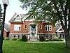 |
(#80002091) |
108 3rd St., NE. 45°58′36″N 94°21′31″W / 45.976716°N 94.358741°W |
Little Falls | 1905 Carnegie library noted for its high state of preservation and atypical American Craftsman architecture.[14] |
| 12 | Little Falls Commercial Historic District | 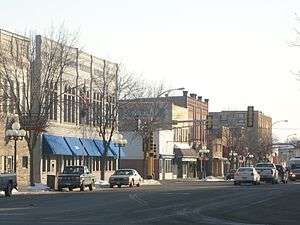 |
(#94000740) |
Roughly 1st St., SE. from 1st Ave, SE. to 1st Ave., NE. 45°58′35″N 94°21′45″W / 45.976467°N 94.362596°W |
Little Falls | Downtown commercial district reflecting Little Falls' abrupt evolution from an agricultural trade center to a lumber and industrial powerhouse, with 32 contributing properties built 1887–1936.[15] |
| 13 | Morrison County Courthouse | 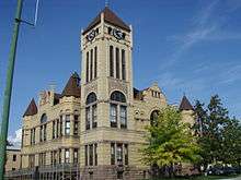 |
(#78001552) |
107 2nd St., SE. 45°58′32″N 94°21′38″W / 45.975581°N 94.36042°W |
Little Falls | County courthouse built 1890–91, noted for its impressive Richardsonian Romanesque architecture of local brick and granite.[16] |
| 14 | Northern Pacific Railway Depot | 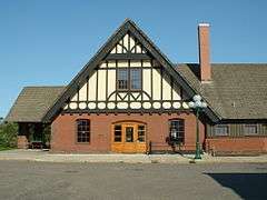 |
(#85001987) |
200 1st St., NW. 45°58′42″N 94°22′11″W / 45.978206°N 94.36982°W |
Little Falls | Shingle Style railway station built 1899–1900, one of architect Cass Gilbert's last projects while in Minnesota and a symbol of the highly influential Northern Pacific Railway.[17] |
| 15 | Our Lady of the Angels Academy | 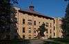 |
(#05001474) |
18801 Riverwood Dr. 46°02′05″N 94°20′18″W / 46.034664°N 94.33822°W |
Belle Prairie Township | 1911 parochial elementary school building enlarged in 1931, a local example of the nationally influential Catholic school system and anchor of the Belle Prairie community.[18] |
| 16 | Pelkey Lake Site | |
(#73000986) |
Address restricted[4] |
Belle Prairie Township | Mounds built between 5000 BCE and 1700 CE.[5] |
| 17 | Zebulon Pike's 1805-1806 Wintering Quarters | |
(#88000538) |
Address restricted[4] |
Little Falls vicinity | Site of the fortified winter camp of Zebulon Pike's first expedition.[5] |
| 18 | Pine Tree Lumber Company Office Building | 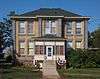 |
(#85001991) |
735 1st St., NE. 45°59′04″N 94°21′39″W / 45.984444°N 94.360719°W |
Little Falls | 1891 office building, the only intact surviving structure of Frederick Weyerhaeuser's Minnesota lumber company (active 1890–1919), one of the state's largest and the major employer in Little Falls.[19] |
| 19 | Rice Lake Prehistoric District | |
(#73000987) |
Address restricted[4] |
Little Falls vicinity | 1000 BCE–1700 CE habitation and mound site.[5] |
| 20 | St. Joseph's Church-Catholic | 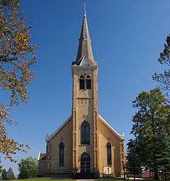 |
(#85001998) |
Main St. 45°58′48″N 94°06′12″W / 45.98°N 94.103333°W |
Pierz | Gothic Revival church built 1886–88 for a German Catholic community attracted by Father Francis Xavier Pierz in the late 1860s.[20] |
| 21 | Stanchfield Logging Camp | |
(#99000190) |
Address restricted[4] |
Camp Ripley Military Reservation[21] | Site of an early commercial logging camp, active over the winter of 1847–48.[5] |
| 22 | Swan River Village Site | |
(#73000988) |
Address restricted[4] |
Little Falls vicinity | Site of an Ojibwe village on the Mississippi River, recorded by Joseph Nicollet in 1836.[5] |
| 23 | William Warren Two Rivers House Site and Peter McDougall Farmstead |  |
(#74001031) |
County Road 231 45°50′36″N 94°20′49″W / 45.843333°N 94.346944°W |
Royalton vicinity | 1874 farmstead on the site of William Whipple Warren's c. 1847 trading post.[5] |
| 24 | Charles A. Weyerhaeuser and Musser Houses | 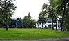 |
(#85001990) |
Highland Ave. 45°58′15″N 94°21′59″W / 45.970723°N 94.366361°W |
Little Falls | Adjoining 1898 houses of second-generation lumber magnates, symbolizing the Minnesota lumber industry and its domination by a few powerful individuals.[22] Now Linden Hill Historical Event Center.[23] |
| 25 | Almond A. White House | 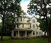 |
(#86000330) |
Cleveland and Beaulieu Sts. 46°20′10″N 94°38′28″W / 46.336214°N 94.641111°W |
Motley | 1902 house with a four-story tower, noted for its prominent and locally unusual Queen Anne architecture.[24] |
Former listings
| [2] | Name on the Register | Image | Date listed | Date removed | Location | City or town | Summary |
|---|---|---|---|---|---|---|---|
| 1 | O. A. Churchill Store | Upload image | (#85001988) | 55 Bay St. |
Little Falls | Long the oldest commercial building in Central Minnesota, built in 1855. Demolished in 1988.[25] | |
| 2 | Clough Township Hall | Upload image | (#85001985) | CR 206 |
Randall vicinity | 1922 Classical Revival meeting hall sided with sheet metal embossed to look like stone.[5] Moved in 2001.[26] |
See also
- List of National Historic Landmarks in Minnesota
- National Register of Historic Places listings in Minnesota
References
- ↑ "National Register of Historic Places: Weekly List Actions". National Park Service, United States Department of the Interior. Retrieved on December 16, 2016.
- 1 2 Numbers represent an ordering by significant words. Various colorings, defined here, differentiate National Historic Landmarks and historic districts from other NRHP buildings, structures, sites or objects.
- ↑ The eight-digit number below each date is the number assigned to each location in the National Register Information System database, which can be viewed by clicking the number.
- 1 2 3 4 5 6 7 Federal and state laws and practices restrict general public access to information regarding the specific location of sensitive archeological sites in many instances. The main reasons for such restrictions include the potential for looting, vandalism, or trampling. See: Knoerl, John; Miller, Diane; Shrimpton, Rebecca H. (1990), Guidelines for Restricting Information about Historic and Prehistoric Resources, National Register Bulletin (29), National Park Service, U.S. Department of the Interior, OCLC 20706997.
- 1 2 3 4 5 6 7 8 9 10 11 Nord, Mary Ann (2003). The National Register of Historic Places in Minnesota. Minnesota Historical Society. ISBN 0-87351-448-3.
- ↑ Pizza, Andrea C. (2014-09-23). "National Register of Historic Places Registration Form: Bridge No. 4969" (PDF). National Park Service. Retrieved 2016-07-16.
- ↑ Jenkinson, Thomas L.; Norene Roberts (1985-03-20). "National Register of Historic Places Inventory—Nomination Form: Barney Burton – Christian Rosenmeier House" (PDF). National Park Service. Retrieved 2014-01-11.
- ↑ Nelson, Charles; Charles Skrief (1980-03-12). "National Register of Historic Places Inventory—Nomination Form: Church of Our Savior" (PDF). National Park Service. Retrieved 2014-01-11.
- ↑ Grossman, John (1970-03-06). "National Register of Historic Places Inventory – Nomination Form: Crow Wing State Park" (PDF). National Park Service. Retrieved 2016-04-10.
- ↑ Location given at "Fort Ripley". Minnesota National Register Properties Database. Minnesota Historical Society. 2009. Retrieved 2014-01-11. NRIS lists site as "address restricted".
- ↑ Grossman, John (1970-03-31). "National Register of Historic Places – Nomination Form: Lindbergh, Charles A., State Park and Lindbergh House" (PDF). National Park Service. Retrieved 2014-01-09.
- ↑ "Charles A. Lindbergh Historic Site". Minnesota Historical Society. Retrieved 2013-02-26.
- ↑ Anderson, Rolf T. (1988-09-09). "National Register of Historic Places Registration Form: Charles A. Lindbergh State Park WPA/Rustic Style Historic Resources" (PDF). National Park Service. Retrieved 2014-01-09.
- ↑ Nelson, Charles W.; Charles W. Skrief (1980-03-10). "National Register of Historic Places Registration Form: Little Falls Carnegie Library" (PDF). National Park Service. Retrieved 2014-01-07.
- ↑ Granger, Susan; et al. "National Register of Historic Places Registration Form: Little Falls Commercial Historic District" (PDF). National Park Service. Retrieved 2014-01-07.
- ↑ Warner, Jan (1978-03-07). "National Register of Historic Places Inventory -- Nomination Form: Morrison County Courthouse" (PDF). National Park Service. Retrieved 2014-01-07.
- ↑ Jenkinson, Thomas L.; Norene Roberts (1985-03-20). "National Register of Historic Places Inventory—Nomination Form: Northern Pacific Railway Depot" (PDF). National Park Service. Retrieved 2014-01-07.
- ↑ Fraser, Clayton B. (2005-05-30). "National Register of Historic Places Registration Form: Our Lady of the Angels Academy" (PDF). National Park Service. Retrieved 2013-11-09.
- ↑ Jenkinson, Thomas L.; Norene Roberts (1985-03-20). "National Register of Historic Places Inventory—Nomination Form: Pine Tree Lumber Company Office Building" (PDF). National Park Service. Retrieved 2014-01-06.
- ↑ Jenkinson, Thomas L.; Norene Roberts (1985-03-20). "National Register of Historic Places Inventory—Nomination Form: St. Joseph's Church" (PDF). National Park Service. Retrieved 2014-01-03.
- ↑ "Stanchfield Logging Camp". Minnesota National Register Properties Database. Minnesota Historical Society. 2009. Retrieved 2014-01-11.
- ↑ Jenkinson, Thomas L.; Norene Roberts (1985-03-20). "National Register of Historic Places Inventory—Nomination Form: Charles A.- Weyerhaeuser and Richard Drew Musser Houses" (PDF). National Park Service. Retrieved 2014-01-03.
- ↑ "Linden Hill Historical Event Center". 2013. Retrieved 2014-01-11.
- ↑ Jenkinson, Thomas L.; Norene Roberts (1985-03-20). "National Register of Historic Places Inventory—Nomination Form: Almond A. White House" (PDF). National Park Service. Retrieved 2014-01-03.
- ↑ El-Hai, Jack (2000). Lost Minnesota: Stories of Vanished Places. Minneapolis: University of Minnesota Press. ISBN 0816635153.
- ↑ "Changes to the National Register of Historic Places in Minnesota, 2003-2010". Minnesota State Historic Preservation Office. 2011-02-01. Retrieved 2013-03-01.
External links
| Wikimedia Commons has media related to National Register of Historic Places in Morrison County, Minnesota. |
- Minnesota National Register Properties Database—Minnesota Historical Society

This article is issued from Wikipedia - version of the 7/16/2016. The text is available under the Creative Commons Attribution/Share Alike but additional terms may apply for the media files.