| [2] |
Name on the Register |
Image |
Date listed[3] |
Location |
City or town |
Description |
|---|
| 1 |
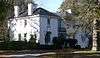
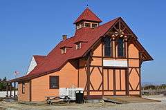
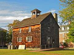
Abbott's Mill |
|
000000001972-08-25-0000August 25, 1972
(#72000300) |
Southwest of Milford
38°53′10″N 75°28′36″W / 38.886111°N 75.476667°W / 38.886111; -75.476667 (Abbott's Mill) |
Milford |
|
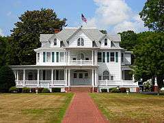
| 2 |
Adams Home Farm |
Upload image |
000000002015-11-23-0000November 23, 2015
(#14000532) |
15293 Adams Rd.
38°46′26″N 75°36′33″W / 38.7738°N 75.6091°W / 38.7738; -75.6091 (Adams Home Farm) |
Greenwood vicinity |
|
| 3 |
Joseph T. Adams House |
|
000000001998-08-28-0000August 28, 1998
(#98001092) |
12 E. Pine St.
38°41′29″N 75°23′03″W / 38.691389°N 75.384167°W / 38.691389; -75.384167 (Joseph T. Adams House) |
Georgetown |
|
| 4 |
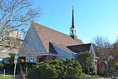
All Saints Episcopal Church |
|
000000001991-08-02-0000August 2, 1991
(#91000910) |
18 Olive Ave. in Lewes and Rehoboth Hundred
38°43′07″N 75°04′42″W / 38.718611°N 75.078333°W / 38.718611; -75.078333 (All Saints Episcopal Church) |
Rehoboth Beach |
|
| 5 |
Avery's Rest Site |
|
000000001978-12-15-0000December 15, 1978
(#78000924) |
Address restricted
|
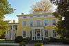
Rehoboth Beach |
|
| 6 |
Baltimore Mills Historic Archaeological Site |
|
000000001997-08-12-0000August 12, 1997
(#97000837) |
Address restricted
|
Omar |
|
| 7 |
Barnes Woods Archeological District |
|
000000001996-12-11-0000December 11, 1996
(#96001413) |
Address restricted
|
Seaford |
|
| 8 |
Bethel Historic District |
|
000000001975-02-10-0000February 10, 1975
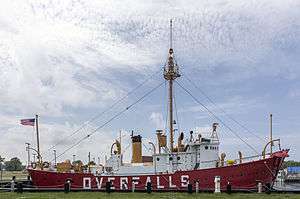
(#75000544) |
0.4 miles west of Laurel
38°34′38″N 75°37′55″W / 38.577222°N 75.631944°W / 38.577222; -75.631944 (Bethel Historic District) |
Bethel |
|
| 9 |
Blackwater Presbyterian Church |
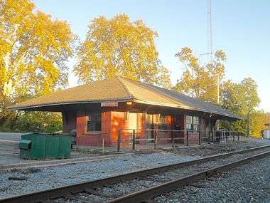
|
000000001976-07-09-0000July 9, 1976
(#76000583) |
West of Clarksville on Delaware Route 54
38°32′44″N 75°09′43″W / 38.545556°N 75.161944°W / 38.545556; -75.161944 (Blackwater Presbyterian Church) |
Clarksville |
|
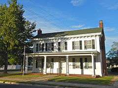
| 10 |
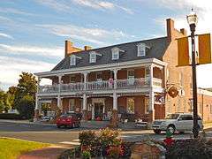
Brick Hotel |
|
000000001979-11-13-0000November 13, 1979
(#79000644) |
The Circle
38°41′23″N 75°23′13″W / 38.689722°N 75.386944°W / 38.689722; -75.386944 (Brick Hotel) |
Georgetown |
|
| 11 |
Bridgeville Historic District |
|
000000001994-04-14-0000April 14, 1994
(#94000361) |
Roughly bounded by Market, Main and Edgewood Sts., School House Ln., Maple Alley and the Norfolk Southern railroad tracks
38°44′28″N 75°36′06″W / 38.741111°N 75.601667°W / 38.741111; -75.601667 (Bridgeville Historic District) |
Bridgeville |
|
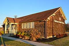
| 12 |
Bridgeville Public Library |
|
000000001990-07-23-0000July 23, 1990
(#90001065) |
210 Market St.
38°44′36″N 75°36′10″W / 38.743333°N 75.602778°W / 38.743333; -75.602778 (Bridgeville Public Library) |
Bridgeville |
|
| 13 |
Building at 200-202A High Street |
Upload image |
000000001987-02-18-0000February 18, 1987
(#86002981) |
200-202A High St.
38°38′26″N 75°36′47″W / 38.640556°N 75.613056°W / 38.640556; -75.613056 (Building at 200-202A High Street) |
Seaford |
|
| 14 |
Building at 218 High Street |
Upload image |
000000001987-02-18-0000February 18, 1987
(#86002983) |
218 High St.
38°38′28″N 75°36′44″W / 38.641111°N 75.612222°W / 38.641111; -75.612222 (Building at 218 High Street) |
Seaford |
|
| 15 |
Building at High and Cannon Streets |
Upload image |
000000001987-02-18-0000February 18, 1987
(#86002985) |
Southeastern corner of High and Cannon Sts.
38°38′27″N 75°36′42″W / 38.640833°N 75.611667°W / 38.640833; -75.611667 (Building at High and Cannon Streets) |
Seaford |
|
| 16 |
Burton-Blackstone-Carey Store |
Upload image |
000000002014-09-10-0000September 10, 2014
(#14000551) |
103 State St.
38°35′30″N 75°17′28″W / 38.5917°N 75.2912°W / 38.5917; -75.2912 (Burton-Blackstone-Carey Store) |
Millsboro |
|
| 17 |
Burton Hardware Store |
Upload image |
000000001978-04-20-0000April 20, 1978
(#78000927) |
High St. and Spring Alley
38°38′29″N 75°36′39″W / 38.641389°N 75.610833°W / 38.641389; -75.610833 (Burton Hardware Store) |
Seaford |
Destroyed in a 2012 fire.[4]
|
| 18 |
Cannon's Ferry |
|
000000001973-07-02-0000July 2, 1973
(#73000561) |
Across the Nanticoke River
38°36′00″N 75°39′25″W / 38.6°N 75.656944°W / 38.6; -75.656944 (Cannon's Ferry) |
Woodland |
|
| 19 |
Cape Henlopen Archeological District |
|
000000001978-11-21-0000November 21, 1978
(#78000920) |
Address restricted
|
Lewes |
|
| 20 |
Carey's Camp Meeting Ground |
Upload image |
000000001973-03-14-0000March 14, 1973
(#73000557) |
West of Millsboro off Delaware Route 24
38°31′24″N 75°24′22″W / 38.523311°N 75.406208°W / 38.523311; -75.406208 (Carey's Camp Meeting Ground) |
Millsboro |
|
| 21 |
Carlisle House |
|
000000001982-04-22-0000April 22, 1982
(#82002364) |
205 S. Front St.
38°54′45″N 75°25′32″W / 38.9125°N 75.425556°W / 38.9125; -75.425556 (Carlisle House) |
Milford |
|
| 22 |
Capt. Ebe Chandler House |
|
000000001979-09-20-0000September 20, 1979
(#79000643) |
Main and Reed Sts.
38°31′01″N 75°14′02″W / 38.516944°N 75.233889°W / 38.516944; -75.233889 (Capt. Ebe Chandler House) |
Frankford |
|
| 23 |
Chipman Potato House |
Upload image |
000000001990-11-15-0000November 15, 1990
(#90001691) |
Junction of Roads 465 and 465A
38°33′37″N 75°32′14″W / 38.560278°N 75.537222°W / 38.560278; -75.537222 (Chipman Potato House) |
Laurel |
|
| 24 |
Chipman's Mill |
Upload image |
000000001978-05-22-0000May 22, 1978
(#78000918) |
East of Laurel on Road 465
38°33′42″N 75°32′24″W / 38.561667°N 75.54°W / 38.561667; -75.54 (Chipman's Mill) |
Laurel |
|
| 25 |
Coleman House |
|
000000001977-04-11-0000April 11, 1977
(#77000392) |
422 Kings Hwy.
38°46′12″N 75°08′31″W / 38.77°N 75.141944°W / 38.77; -75.141944 (Coleman House) |
Lewes |
|
| 26 |
Collins Potato House |
Upload image |
000000001990-11-15-0000November 15, 1990
(#90001692) |
Junction of Roads 509 and 510A
38°31′35″N 75°36′18″W / 38.526389°N 75.605°W / 38.526389; -75.605 (Collins Potato House) |
Laurel |
|
| 27 |
Cool Spring Presbyterian Church |
|
000000001982-08-31-0000August 31, 1982
(#82002363) |
West of Lewes on Road 247
38°44′13″N 75°14′21″W / 38.736944°N 75.239167°W / 38.736944; -75.239167 (Cool Spring Presbyterian Church) |
Lewes |
|
| 28 |
J. W. Cox Dry Goods Store |
Upload image |
000000001987-02-18-0000February 18, 1987
(#86002982) |
214 High St.
38°38′27″N 75°36′44″W / 38.640833°N 75.612222°W / 38.640833; -75.612222 (J. W. Cox Dry Goods Store) |
Seaford |
|
| 29 |
Robert Davis Farmhouse |
Upload image |
000000001979-04-26-0000April 26, 1979
(#79003309) |
South of Delaware Route 24
38°36′30″N 75°12′13″W / 38.608333°N 75.203611°W / 38.608333; -75.203611 (Robert Davis Farmhouse) |
Millsboro |
|
| 30 |
Dr. Dawson House |
|
000000001983-01-07-0000January 7, 1983
(#83001355) |
200 SE. Front St.
38°54′43″N 75°25′34″W / 38.911944°N 75.426111°W / 38.911944; -75.426111 (Dr. Dawson House) |
Milford |
The house has been replaced by a modern house
|
| 31 |
De Vries Palisade |
|
000000001972-02-23-0000February 23, 1972
(#72000299) |
Pilottown Road (Front Street)
38°49′57″N 75°17′34″W / 38.8325°N 75.292777°W / 38.8325; -75.292777 (De Vries Palisade) |
Lewes |
|
| 32 |
Deep Creek Furnace Site |
|
000000001977-10-20-0000October 20, 1977
(#77000396) |
Address restricted
|
Middleford |
|
| 33 |
Delaware Boundary Markers |
|
000000001975-02-18-0000February 18, 1975
(#75002101) |
Delaware state boundary lines with Maryland and Pennsylvania
Coordinates missing |
Not applicable |
|
| 34 |
Delaware Breakwater and Lewes Harbor |
|
000000001976-12-12-0000December 12, 1976
(#76000586) |
East of Lewes at Cape Henlopen
38°49′03″N 75°06′23″W / 38.8175°N 75.106389°W / 38.8175; -75.106389 (Delaware Breakwater and Lewes Harbor) |
Lewes |
|
| 35 |
Dickerson Potato House |
Upload image |
000000001990-11-15-0000November 15, 1990
(#90001693) |
Junction of Roads 494 and 498
38°33′00″N 75°40′28″W / 38.55°N 75.674444°W / 38.55; -75.674444 (Dickerson Potato House) |
Delmar |
|
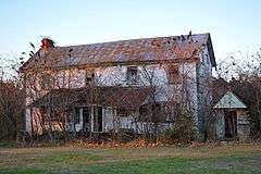
| 36 |
Dodd Homestead |
Upload image |
000000001982-08-26-0000August 26, 1982
(#82002367) |
West of Rehoboth Beach on Delaware Route 1
38°43′01″N 75°06′40″W / 38.716944°N 75.111111°W / 38.716944; -75.111111 (Dodd Homestead) |
Rehoboth Beach |
|
| 37 |
Draper House |
|
000000001982-04-22-0000April 22, 1982
(#82002365) |
200 Lakeview Ave.
38°54′36″N 75°26′00″W / 38.91°N 75.433333°W / 38.91; -75.433333 (Draper House) |
Milford |
|
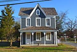
| 38 |
Draper-Adkins House |
|
000000001973-04-11-0000April 11, 1973
(#73000558) |
204 Federal St.
38°46′36″N 75°18′41″W / 38.776667°N 75.311389°W / 38.776667; -75.311389 (Draper-Adkins House) |
Milton |
|
| 39 |
Egglinton Hall |
|
000000001983-01-07-0000January 7, 1983
(#83001359) |
700 SE. 2nd St.
38°54′34″N 75°25′15″W / 38.909444°N 75.420833°W / 38.909444; -75.420833 (Egglinton Hall) |
Milford |
|
| 40 |
Ellendale State Forest Picnic Facility |
Upload image |
000000001991-07-22-0000July 22, 1991
(#91000913) |
U.S. Route 113, ½ mile south of Delaware Route 16 in Georgetown Hundred
38°46′32″N 75°26′15″W / 38.775556°N 75.4375°W / 38.775556; -75.4375 (Ellendale State Forest Picnic Facility) |
Ellendale |
|
| 41 |
Eratt House |
Upload image |
000000001983-10-29-0000October 29, 1983
(#83001409) |
West of Bridgeville on Road 572
38°45′21″N 75°42′40″W / 38.755833°N 75.711111°W / 38.755833; -75.711111 (Eratt House) |
Bridgeville |
|
| 42 |
Evans-West House |
Upload image |
000000002015-12-01-0000December 1, 2015
(#15000844) |
40 West Ave.
38°32′48″N 75°05′17″W / 38.546732°N 75.088141°W / 38.546732; -75.088141 (Evans-West House) |
Ocean View |
|
| 43 |
Peter S. Faucett House |
|
000000001985-09-05-0000September 5, 1985
(#85002006) |
W. Laurel St.
38°41′24″N 75°23′18″W / 38.69°N 75.388333°W / 38.69; -75.388333 (Peter S. Faucett House) |
Georgetown |
|
| 44 |
Fenwick Island Lighthouse Station |
|
000000001979-08-13-0000August 13, 1979
(#79000642) |
Off Delaware Route 54
38°27′05″N 75°03′19″W / 38.451389°N 75.055278°W / 38.451389; -75.055278 (Fenwick Island Lighthouse Station) |
Fenwick Island |
|
| 45 |
First Broiler House |
Upload image |
000000001974-07-03-0000July 3, 1974
(#74000607) |
University of Delaware Experimental Station
38°38′09″N 75°27′16″W / 38.635833°N 75.454444°W / 38.635833; -75.454444 (First Broiler House) |
Georgetown |
|
| 46 |
First National Bank of Seaford |
Upload image |
000000001987-02-18-0000February 18, 1987
(#86002972) |
118 Pine St.
38°38′31″N 75°36′44″W / 38.641944°N 75.612222°W / 38.641944; -75.612222 (First National Bank of Seaford) |
Seaford |
|
| 47 |
Fisher Homestead |
Upload image |
000000001980-12-11-0000December 11, 1980
(#80000941) |
West of Lewes
38°47′21″N 75°12′23″W / 38.789167°N 75.206389°W / 38.789167; -75.206389 (Fisher Homestead) |
Lewes |
|
| 48 |
Fisher's Paradise |
|
000000001972-12-04-0000December 4, 1972
(#72000298) |
624 Pilottown Rd.
38°47′01″N 75°09′26″W / 38.783611°N 75.157222°W / 38.783611; -75.157222 (Fisher's Paradise) |
Lewes |
|
| 49 |
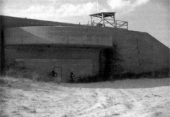
Fort Miles Historic District |
|
000000002004-09-30-0000September 30, 2004
(#04001076) |
At the confluence of the Atlantic Ocean and Delaware Bay
38°46′15″N 75°17′53″W / 38.770833°N 75.298056°W / 38.770833; -75.298056 (Fort Miles Historic District) |
Lewes |
|
| 50 |
Georgetown Coal Gasification Plant |
Upload image |
000000001985-09-30-0000September 30, 1985
(#85002696) |
N. Railroad Ave.
38°41′40″N 75°23′18″W / 38.694444°N 75.388333°W / 38.694444; -75.388333 (Georgetown Coal Gasification Plant) |
Georgetown |
|
| 51 |
Grier House |
|
000000001983-01-07-0000January 7, 1983
(#83001410) |
301 Lakeview Ave.
38°54′32″N 75°26′07″W / 38.908889°N 75.435278°W / 38.908889; -75.435278 (Grier House) |
Milford |
|
| 52 |
Stella Pepper Gyles House |
Upload image |
000000001979-11-13-0000November 13, 1979
(#79000645) |
Southwest of Georgetown at the Northwest corner of Delaware Roads 518 and 62
38°39′43″N 75°24′23″W / 38.661944°N 75.406389°W / 38.661944; -75.406389 (Stella Pepper Gyles House) |
Georgetown |
|
| 53 |
Col. David Hall House |
|
000000001976-04-26-0000April 26, 1976
(#76000585) |
107 King's Hwy.
38°46′25″N 75°08′20″W / 38.773611°N 75.138889°W / 38.773611; -75.138889 (Col. David Hall House) |
Lewes |
|
| 54 |
Harmon School |
|
000000001979-04-26-0000April 26, 1979
(#79003314) |
26673 John J. Williams Hwy
38°36′51″N 75°12′08″W / 38.6141°N 75.2023°W / 38.6141; -75.2023 (Harmon School) |
Millsboro |
|
| 55 |
Isaac Harmon Farmhouse |
|
000000001979-04-26-0000April 26, 1979
(#79003315) |
Road 312A
38°35′56″N 75°11′55″W / 38.598889°N 75.198611°W / 38.598889; -75.198611 (Isaac Harmon Farmhouse) |
Millsboro |
|
| 56 |
Harmony Church |
|
000000001979-04-26-0000April 26, 1979
(#79003308) |
Delaware Route 24, east of Road 313
38°36′21″N 75°13′08″W / 38.605833°N 75.218889°W / 38.605833; -75.218889 (Harmony Church) |
Millsboro |
|
| 57 |
Hazzard House |
|
000000001973-07-02-0000July 2, 1973
(#73000559) |
327 Union St.
38°46′55″N 75°18′46″W / 38.781944°N 75.312778°W / 38.781944; -75.312778 (Hazzard House) |
Milton |
|
| 58 |
Hearn and Rawlins Mill |
Upload image |
000000001978-05-22-0000May 22, 1978
(#78000928) |
North of Seaford on Road 13
38°40′44″N 75°35′39″W / 38.678889°N 75.594167°W / 38.678889; -75.594167 (Hearn and Rawlins Mill) |
Seaford |
|
| 59 |
Hearn Potato House |
Upload image |
000000001990-11-15-0000November 15, 1990
(#90001694) |
0.6 miles north of junction of Roads 62 and 74
38°35′08″N 75°27′35″W / 38.585556°N 75.459722°W / 38.585556; -75.459722 (Hearn Potato House) |
Laurel |
|
| 60 |
Hebron Methodist Protestant Church and Cemetery |
Upload image |
000000002015-05-18-0000May 18, 2015
(#15000220) |
18282 Seashore Hwy.
38°41′53″N 75°25′43″W / 38.6981°N 75.4285°W / 38.6981; -75.4285 (Hebron Methodist Protestant Church and Cemetery) |
Georgetown vicinity |
|
| 61 |
Highball Signal |
|
000000001973-07-02-0000July 2, 1973
(#73000553) |
City park, near Norfolk Southern railroad line.
38°27′23″N 75°34′44″W / 38.456389°N 75.578889°W / 38.456389; -75.578889 (Highball Signal) |
Delmar |
|
| 62 |
E. L. Hitch Potato House |
Upload image |
000000001990-11-15-0000November 15, 1990
(#90001695) |
Junction of Roads 480 and 489
38°36′11″N 75°33′48″W / 38.603056°N 75.563333°W / 38.603056; -75.563333 (E. L. Hitch Potato House) |
Laurel |
|
| 63 |
Ames Hitchens Chicken Farm |
Upload image |
000000001979-04-26-0000April 26, 1979
(#79003311) |
North of Delaware Route 24
38°36′25″N 75°13′06″W / 38.606944°N 75.218333°W / 38.606944; -75.218333 (Ames Hitchens Chicken Farm) |
Millsboro |
|
| 64 |
Hopkins' Covered Bridge Farm |
Upload image |
000000001991-08-02-0000August 2, 1991
(#91000912) |
Northern side of Road 262 east of its junction with Road 286 in Lewes and Rehoboth Hundred
38°43′10″N 75°13′14″W / 38.719444°N 75.220556°W / 38.719444; -75.220556 (Hopkins' Covered Bridge Farm) |
Lewes |
|
| 65 |
Indian Mission Church |
Upload image |
000000001979-04-26-0000April 26, 1979
(#79003307) |
Junction of Delaware Route 5 and Road 48
38°40′25″N 75°14′05″W / 38.673611°N 75.234722°W / 38.673611; -75.234722 (Indian Mission Church) |
Millsboro |
|
| 66 |
Indian Mission School |
|
000000001979-04-26-0000April 26, 1979
(#79003312) |
27073 John J. Williams Hwy.
38°36′22″N 75°12′42″W / 38.6060°N 75.2117°W / 38.6060; -75.2117 (Indian Mission School) |
Millsboro |
|
| 67 |
Indian River Archeological Complex |
|
000000001978-12-15-0000December 15, 1978
(#78000922) |
Address restricted
|
Millsboro |
|
| 68 |
Indian River Life Saving Service Station |
|
000000001976-09-29-0000September 29, 1976
(#76000582) |
North of Bethany Beach on Delaware Route 1
38°38′01″N 75°04′03″W / 38.633611°N 75.0675°W / 38.633611; -75.0675 (Indian River Life Saving Service Station) |
Bethany Beach |
|
| 69 |
Johnson School |
|
000000001979-04-26-0000April 26, 1979
(#79003313) |
Delaware Route 24 between Roads 309 and 310
38°36′13″N 75°13′50″W / 38.603611°N 75.230556°W / 38.603611; -75.230556 (Johnson School) |
Millsboro |
|
| 70 |
Judge's House and Law Office |
|
000000001979-11-13-0000November 13, 1979
(#79000646) |
100 and 104 W. Market St.
38°41′21″N 75°23′17″W / 38.689167°N 75.388056°W / 38.689167; -75.388056 (Judge's House and Law Office) |
Georgetown |
|
| 71 |
Laurel Historic District |
Upload image |
000000001988-07-27-0000July 27, 1988
(#88001056) |
West St. to Rossakatum Creek to 10th St.
38°33′22″N 75°34′17″W / 38.556111°N 75.571389°W / 38.556111; -75.571389 (Laurel Historic District) |
Laurel |
|
| 72 |
Lawrence |
Upload image |
000000001978-05-22-0000May 22, 1978
(#78000929) |
North of Seaford on U.S. Route 13A
38°39′43″N 75°36′04″W / 38.661944°N 75.601111°W / 38.661944; -75.601111 (Lawrence) |
Seaford |
|
| 73 |
Lewes Historic District |
|
000000001977-09-19-0000September 19, 1977
(#77000393) |
Ship-carpenter, Front, Savannah, 2nd, 3rd, and 4th Sts.
38°46′29″N 75°08′34″W / 38.774722°N 75.142778°W / 38.774722; -75.142778 (Lewes Historic District) |
Lewes |
|
| 74 |
Lewes Presbyterian Church |
|
000000001977-10-05-0000October 5, 1977
(#77000394) |
100 Kings Highway
38°46′20″N 75°08′23″W / 38.772222°N 75.139722°W / 38.772222; -75.139722 (Lewes Presbyterian Church) |
Lewes |
|
| 75 |
Lightship WAL 539 |
|
000000001989-02-16-0000February 16, 1989
(#89000006) |
Lewes-Rehoboth Canal between Shipcarpenter and Mulberry Sts.
38°46′42″N 75°08′30″W / 38.778333°N 75.141667°W / 38.778333; -75.141667 (Lightship WAL 539) |
Lewes |
Unique lightship was one of few that remained in service during World War II
|
| 76 |
Peter Marsh House |
|
000000001977-11-23-0000November 23, 1977
(#77000397) |
10 Dodd's Lane
38°43′30″N 75°05′11″W / 38.725°N 75.086389°W / 38.725; -75.086389 (Peter Marsh House) |
Rehoboth Beach |
|
| 77 |
Maston House |
|
000000001975-03-31-0000March 31, 1975
(#75000545) |
3 miles north of Seaford on Seaford-Atlanta Rd.
38°41′20″N 75°38′58″W / 38.688889°N 75.649444°W / 38.688889; -75.649444 (Maston House) |
Seaford |
|
| 78 |
Maull House |
|
000000001970-11-20-0000November 20, 1970April 26, 1978 (boundary increase)
(#70000175) |
542 Pilottown Rd.
38°46′49″N 75°09′04″W / 38.780258°N 75.151183°W / 38.780258; -75.151183 (Maull House) |
Lewes |
|
| 79 |
McColley's Chapel |
|
000000002011-11-30-0000November 30, 2011
(#11000859) |
18168 Redden Rd.
38°44′34″N 75°25′56″W / 38.742886°N 75.432281°W / 38.742886; -75.432281 (McColley's Chapel) |
Georgetown |
|
| 80 |
Melson House |
Upload image |
000000001978-03-08-0000March 8, 1978
(#78000914) |
North of Atlanta on Road 30
38°43′26″N 75°40′55″W / 38.723889°N 75.681944°W / 38.723889; -75.681944 (Melson House) |
Atlanta |
|
| 81 |
Dr. John W. Messick House and Office |
Upload image |
000000001987-09-09-0000September 9, 1987
(#87001499) |
144 E. Market St.
38°41′58″N 75°23′02″W / 38.699444°N 75.383889°W / 38.699444; -75.383889 (Dr. John W. Messick House and Office) |
Georgetown |
|
| 82 |
Milford Railroad Station |
|
000000001983-01-07-0000January 7, 1983
(#83001356) |
Delaware Route 36
38°54′38″N 75°25′57″W / 38.910556°N 75.4325°W / 38.910556; -75.4325 (Milford Railroad Station) |
Milford |
|
| 83 |
Milford Shipyard Area Historic District |
|
000000001983-01-07-0000January 7, 1983
(#83001411) |
Roughly bounded by Mispillion River, Franklin, Front and Marshall Sts.
38°54′46″N 75°25′24″W / 38.912778°N 75.423333°W / 38.912778; -75.423333 (Milford Shipyard Area Historic District) |
Milford |
|
| 84 |
Milton Historic District |
|
000000001982-06-25-0000June 25, 1982
(#82002366) |
Delaware Route 5
38°46′35″N 75°18′35″W / 38.776389°N 75.309722°W / 38.776389; -75.309722 (Milton Historic District) |
Milton |
|
| 85 |
Mispillion Lighthouse and Beacon Tower |
|
000000001987-02-18-0000February 18, 1987
(#86002919) |
Northeastern end of Road 203
38°56′50″N 75°18′56″W / 38.947222°N 75.315556°W / 38.947222; -75.315556 (Mispillion Lighthouse and Beacon Tower) |
Milford |
|
| 86 |
Moore Potato House |
Upload image |
000000001990-11-15-0000November 15, 1990
(#90001696) |
Southeast of junction of Roads 72 and 463
38°31′15″N 75°30′01″W / 38.520833°N 75.500278°W / 38.520833; -75.500278 (Moore Potato House) |
Laurel |
|
| 87 |
National Harbor of Refuge and Delaware Breakwater Harbor Historic District |
|
000000001989-03-27-0000March 27, 1989
(#89000289) |
Mouth of Delaware Bay at Cape Henlopen
38°47′59″N 75°06′27″W / 38.799722°N 75.1075°W / 38.799722; -75.1075 (National Harbor of Refuge and Delaware Breakwater Harbor Historic District) |
Lewes |
|
| 88 |
Norwood House |
Upload image |
000000001982-10-25-0000October 25, 1982
(#82001030) |
Southwest of Lewes on U.S. Route 9
38°44′47″N 75°10′48″W / 38.746389°N 75.18°W / 38.746389; -75.18 (Norwood House) |
Belltown |
|
| 89 |
Old Bridgeville Fire House |
Upload image |
000000001984-08-09-0000August 9, 1984
(#84000856) |
102 William St.
38°44′34″N 75°36′04″W / 38.742887°N 75.600998°W / 38.742887; -75.600998 (Old Bridgeville Fire House) |
Bridgeville |
|
| 90 |
Old Christ Church |
|
000000001972-04-13-0000April 13, 1972
(#72000297) |
Southeast of Laurel at junction of Roads 465 and 465A
38°33′40″N 75°32′16″W / 38.561111°N 75.537778°W / 38.561111; -75.537778 (Old Christ Church) |
Laurel |
|
| 91 |
Old Sussex County Courthouse |
|
000000001971-03-24-0000March 24, 1971
(#71000236) |
S. Bedford St.
38°41′23″N 75°23′08″W / 38.689768°N 75.385479°W / 38.689768; -75.385479 (Old Sussex County Courthouse) |
Georgetown |
|
| 92 |
Pagan Creek Dike |
Upload image |
000000001973-06-18-0000June 18, 1973
(#73000555) |
Pagan Creek near New Rd.
38°46′16″N 75°09′53″W / 38.771111°N 75.164722°W / 38.771111; -75.164722 (Pagan Creek Dike) |
Lewes |
|
| 93 |
David Carlton Pepper Farm |
Upload image |
000000001979-09-24-0000September 24, 1979
(#79000647) |
South of Georgetown on Road 469
38°39′47″N 75°23′33″W / 38.663056°N 75.3925°W / 38.663056; -75.3925 (David Carlton Pepper Farm) |
Georgetown |
|
| 94 |
Perry-Shockley House |
Upload image |
000000001985-09-05-0000September 5, 1985
(#85002008) |
219 Washington St.
38°35′15″N 75°17′41″W / 38.5875°N 75.294722°W / 38.5875; -75.294722 (Perry-Shockley House) |
Millsboro |
|
| 95 |
Phillips Potato House |
Upload image |
000000001990-11-15-0000November 15, 1990
(#90001697) |
Southwest of junction of Roads 492 and 492A
38°33′20″N 75°36′59″W / 38.555556°N 75.616389°W / 38.555556; -75.616389 (Phillips Potato House) |
Laurel |
|
| 96 |
Pine Grove Furnace Site |
|
000000001978-01-26-0000January 26, 1978
(#78000917) |
Address restricted
|
Concord |
|
| 97 |
Gov. James Ponder House |
|
000000001973-05-24-0000May 24, 1973
(#73000560) |
416 Federal St.
38°46′26″N 75°18′49″W / 38.773889°N 75.313611°W / 38.773889; -75.313611 (Gov. James Ponder House) |
Milton |
|
| 98 |
Poplar Thicket |
Upload image |
000000001978-12-29-0000December 29, 1978
(#78003177) |
west of the Indian River inlet on Long Neck
38°37′13″N 75°08′14″W / 38.620183°N 75.137175°W / 38.620183; -75.137175 (Poplar Thicket) |
Bethany Beach |
|
| 99 |
Portsville Lighthouse |
Upload image |
000000001987-09-08-0000September 8, 1987
(#87001514) |
Northern side of Road 493
38°33′43″N 75°37′48″W / 38.561944°N 75.63°W / 38.561944; -75.63 (Portsville Lighthouse) |
Portsville |
|
| 100 |
Prince George's Chapel |
|
000000001971-03-24-0000March 24, 1971
(#71000235) |
East of Dagsboro on Delaware Route 26
38°32′54″N 75°14′22″W / 38.548333°N 75.239444°W / 38.548333; -75.239444 (Prince George's Chapel) |
Dagsboro |
|
| 101 |
Ralph Potato House |
Upload image |
000000001990-11-15-0000November 15, 1990
(#90001698) |
Southeast of junction of Roads 493 and 494
38°32′15″N 75°38′19″W / 38.5375°N 75.638611°W / 38.5375; -75.638611 (Ralph Potato House) |
Laurel |
|
| 102 |
Redden Forest Lodge, Forester's House, and Stable |
|
000000001980-11-25-0000November 25, 1980
(#80000940) |
Redden State Forest
38°44′29″N 75°24′43″W / 38.741389°N 75.411944°W / 38.741389; -75.411944 (Redden Forest Lodge, Forester's House, and Stable) |
Georgetown |
|
| 103 |
Ricards House-Linden Hall |
Upload image |
000000001982-08-26-0000August 26, 1982
(#82002360) |
East of Bridgeville on U.S. Route 13
38°46′15″N 75°35′35″W / 38.770833°N 75.593056°W / 38.770833; -75.593056 (Ricards House-Linden Hall) |
Bridgeville |
|
| 104 |
Richards Historic District |
Upload image |
000000001983-12-15-0000December 15, 1983
(#83003522) |
Road 34
38°47′15″N 75°38′26″W / 38.7875°N 75.640556°W / 38.7875; -75.640556 (Richards Historic District) |
Greenwood |
|
| 105 |
Richards Mansion |
|
000000001979-07-26-0000July 26, 1979
(#79000648) |
N. Bedford St. and the Circle
38°41′26″N 75°23′13″W / 38.690556°N 75.386944°W / 38.690556; -75.386944 (Richards Mansion) |
Georgetown |
|
| 106 |
Rider Potato House |
Upload image |
000000001990-11-15-0000November 15, 1990
(#90001699) |
Southeast of junction of Roads 505 and 506
38°33′37″N 75°32′14″W / 38.560278°N 75.537222°W / 38.560278; -75.537222 (Rider Potato House) |
Laurel |
|
| 107 |
David Robbins Homestead |
|
000000002013-01-02-0000January 2, 2013
(#11000878) |
26285 Broadkill Rd.
38°47′40″N 75°17′22″W / 38.794383°N 75.289568°W / 38.794383; -75.289568 (David Robbins Homestead) |
Milton |
|
| 108 |
Jesse Robinson House |
Upload image |
000000001982-08-26-0000August 26, 1982
(#82002368) |
High St.
38°38′31″N 75°36′31″W / 38.641944°N 75.608611°W / 38.641944; -75.608611 (Jesse Robinson House) |
Seaford |
|
| 109 |
Roosevelt Inlet Shipwreck |
|
000000002006-11-16-0000November 16, 2006
(#06001056) |
In Delaware Bay near Roosevelt Inlet
|
Lewes |
18th century commercial shipwreck
|
| 110 |
Ross Point School |
Upload image |
000000002001-08-17-0000August 17, 2001
(#01000886) |
Road 448 near junction with Road 62
38°33′23″N 75°27′15″W / 38.556389°N 75.454167°W / 38.556389; -75.454167 (Ross Point School) |
Laurel |
|
| 111 |
Edgar and Rachel Ross House |
Upload image |
000000001997-09-11-0000September 11, 1997
(#97001118) |
413 High St.
38°38′36″N 75°36′36″W / 38.643333°N 75.61°W / 38.643333; -75.61 (Edgar and Rachel Ross House) |
Seaford |
|
| 112 |
Gov. William H. Ross House |
|
000000001977-10-28-0000October 28, 1977
(#77000399) |
North of Seaford on Market St.
38°39′18″N 75°37′05″W / 38.655°N 75.618056°W / 38.655; -75.618056 (Gov. William H. Ross House) |
Seaford |
|
| 113 |
William Russell House |
|
000000001977-04-18-0000April 18, 1977
(#77000395) |
410 Pilot Town Rd.
38°46′46″N 75°09′03″W / 38.779444°N 75.150833°W / 38.779444; -75.150833 (William Russell House) |
Lewes |
|
| 114 |
St. George's Chapel, Lewes |
Upload image |
000000001973-11-30-0000November 30, 1973
(#73000556) |
9 miles southwest of Lewes on Delaware Route 5
38°41′08″N 75°13′09″W / 38.685556°N 75.219167°W / 38.685556; -75.219167 (St. George's Chapel, Lewes) |
Lewes |
|
| 115 |
St. John's Methodist Church |
Upload image |
000000001990-07-12-0000July 12, 1990
(#90001071) |
Springfield Crossroads, junction of Delaware Route 30 and Road 47
38°40′54″N 75°18′28″W / 38.681667°N 75.307778°W / 38.681667; -75.307778 (St. John's Methodist Church) |
Georgetown |
|
| 116 |
St. Luke's Protestant Episcopal Church |
|
000000001977-10-28-0000October 28, 1977
(#77000400) |
Front St.
38°38′37″N 75°36′33″W / 38.643611°N 75.609167°W / 38.643611; -75.609167 (St. Luke's Protestant Episcopal Church) |
Seaford |
|
| 117 |
St. Paul's Episcopal Church |
|
000000001979-11-13-0000November 13, 1979
(#79000649) |
E. Pine St
38°41′26″N 75°22′58″W / 38.690556°N 75.382778°W / 38.690556; -75.382778 (St. Paul's Episcopal Church) |
Georgetown |
|
| 118 |
Scott's Store |
Upload image |
000000001983-10-29-0000October 29, 1983
(#83001412) |
Northwest of Bridgeville on Delaware Route 404
38°46′49″N 75°40′04″W / 38.780278°N 75.667778°W / 38.780278; -75.667778 (Scott's Store) |
Bridgeville |
|
| 119 |
Seaford Station Complex |
|
000000001978-06-15-0000June 15, 1978
(#78000930) |
Nanticoke River at Delaware Railroad Bridge
38°38′18″N 75°36′53″W / 38.638333°N 75.614722°W / 38.638333; -75.614722 (Seaford Station Complex) |
Seaford |
|
| 120 |
Short Homestead |
Upload image |
000000001982-04-01-0000April 1, 1982
(#82002361) |
West of Georgetown at Roads 526 and 529
38°40′54″N 75°30′04″W / 38.681667°N 75.501111°W / 38.681667; -75.501111 (Short Homestead) |
Georgetown |
|
| 121 |
Thomas Sipple House |
|
000000001985-09-05-0000September 5, 1985
(#85002007) |
N. Bedford & New Sts.
38°41′34″N 75°23′22″W / 38.692778°N 75.389444°W / 38.692778; -75.389444 (Thomas Sipple House) |
Georgetown |
|
| 122 |
South Milford Historic District |
|
000000001983-01-07-0000January 7, 1983
(#83001358) |
Roughly bounded by Mispillion River, Maple Ave., Church and Washington Sts.
38°54′37″N 75°25′42″W / 38.910278°N 75.428333°W / 38.910278; -75.428333 (South Milford Historic District) |
Milford |
|
| 123 |
Spring Banke |
Upload image |
000000001976-04-30-0000April 30, 1976
(#76000584) |
Northeast of Clarksville on Delaware Route 26 and Irons Lane
38°33′09″N 75°08′24″W / 38.5525°N 75.14°W / 38.5525; -75.14 (Spring Banke) |
Clarksville |
|
| 124 |
Spring Garden |
Upload image |
000000001982-08-26-0000August 26, 1982
(#82002362) |
Northeast of Laurel on Delaware Ave.
38°33′52″N 75°34′02″W / 38.564444°N 75.567222°W / 38.564444; -75.567222 (Spring Garden) |
Laurel |
|
| 125 |
Stanley Potato House |
Upload image |
000000001990-11-15-0000November 15, 1990
(#90001700) |
North of junction of Roads 68 and 451
38°31′04″N 75°32′35″W / 38.517778°N 75.543056°W / 38.517778; -75.543056 (Stanley Potato House) |
Laurel |
|
| 126 |
Sudler House |
|
000000001974-12-31-0000December 31, 1974
(#74000606) |
N. Main St.
38°44′50″N 75°35′58″W / 38.747222°N 75.599444°W / 38.747222; -75.599444 (Sudler House) |
Bridgeville |
|
| 127 |
Sussex County Courthouse and the Circle |
|
000000001973-06-04-0000June 4, 1973
(#73000554) |
The Circle
38°41′32″N 75°23′05″W / 38.692222°N 75.384722°W / 38.692222; -75.384722 (Sussex County Courthouse and the Circle) |
Georgetown |
|
| 128 |
Sussex National Bank of Seaford |
Upload image |
000000001987-02-18-0000February 18, 1987
(#86002977) |
130 High St.
38°38′26″N 75°36′49″W / 38.640556°N 75.613611°W / 38.640556; -75.613611 (Sussex National Bank of Seaford) |
Seaford |
|
| 129 |
Teddy's Tavern |
Upload image |
000000001991-07-22-0000July 22, 1991
(#91000911) |
Eastern side of U.S. Route 113 (Du Pont Boulevard), 0.6 miles north of its junction with Delaware Route 16 in Cedar Creek Hundred
38°48′53″N 75°26′19″W / 38.814722°N 75.438611°W / 38.814722; -75.438611 (Teddy's Tavern) |
Ellendale |
|
| 130 |
Thompson's Loss and Gain Site |
|
000000001978-09-13-0000September 13, 1978
(#78000925) |
Address restricted
|
Rehoboth Beach |
|
| 131 |
Thompsons Island Site |
|
000000001978-11-15-0000November 15, 1978
(#78000926) |
Address restricted
|
Rehoboth Beach |
|
| 132 |
Townsend Site |
|
000000001978-09-01-0000September 1, 1978
(#78000919) |
Address restricted
|
Lewes |
|
| 133 |
Trinity Methodist Episcopal Church |
Upload image |
000000001978-05-05-0000May 5, 1978
(#78000916) |
Northwest of Bridgeville on Road 31
38°45′13″N 75°40′41″W / 38.753611°N 75.678056°W / 38.753611; -75.678056 (Trinity Methodist Episcopal Church) |
Bridgeville |
|
| 134 |
Tunnell-West House |
|
000000002012-07-03-0000July 3, 2012
(#12000379) |
39 Central Ave.
38°32′53″N 75°05′22″W / 38.54809°N 75.089344°W / 38.54809; -75.089344 (Tunnell-West House) |
Ocean View |
|
| 135 |
Union Wesley Methodist Episcopal Church Complex |
Upload image |
000000002014-09-17-0000September 17, 2014
(#14000617) |
Powell Farm Rd.
38°32′42″N 75°08′49″W / 38.5450°N 75.147°W / 38.5450; -75.147 (Union Wesley Methodist Episcopal Church Complex) |
Clarksville vicinity |
|
| 136 |
Warren's Mill |
Upload image |
000000001978-09-13-0000September 13, 1978
(#78000923) |
Northwest of Millsboro on Road 326
38°35′45″N 75°18′14″W / 38.595915°N 75.30376°W / 38.595915; -75.30376 (Warren's Mill) |
Millsboro |
|
| 137 |
Warrington Site |
|
000000001977-10-20-0000October 20, 1977
(#77000398) |
Address restricted
|
Rehoboth Beach |
|
| 138 |
West Potato House |
Upload image |
000000001990-11-15-0000November 15, 1990
(#90001701) |
U.S. Route 13 north of its junction with Road 454A
38°28′48″N 75°34′18″W / 38.48°N 75.571667°W / 38.48; -75.571667 (West Potato House) |
Delmar |
|
| 139 |
West Woods Methodist Episcopal Church |
Upload image |
000000002007-07-20-0000July 20, 2007
(#07000246) |
West Woods Rd., west of Millsboro Hwy.
38°30′29″N 75°22′12″W / 38.508056°N 75.37°W / 38.508056; -75.37 (West Woods Methodist Episcopal Church) |
Gumboro |
|
| 140 |
Wilgus Site |
|
000000001978-03-30-0000March 30, 1978
(#78000915) |
Address restricted
|
Bethany Beach |
|
| 141 |
Wolfe's Neck Site |
|
000000001978-11-21-0000November 21, 1978
(#78000921) |
Address restricted
|
Lewes |
|
| 142 |
Woman's Christian Temperance Union Fountain |
|
000000002009-02-28-0000February 28, 2009
(#09000052) |
Boardwalk at Rehoboth Avenue
38°43′00″N 75°04′34″W / 38.716667°N 75.076194°W / 38.716667; -75.076194 (Woman's Christian Temperance Union Fountain) |
Rehoboth Beach |
|
| 143 |
Wright Potato House |
Upload image |
000000001990-11-15-0000November 15, 1990
(#90001702) |
Southwest of junction of Delaware Route 24 and Road 510
38°31′57″N 75°36′35″W / 38.5325°N 75.609722°W / 38.5325; -75.609722 (Wright Potato House) |
Laurel |
|
| 144 |
Gardiner Wright Mansion |
|
000000001979-11-15-0000November 15, 1979
(#79000650) |
228 S. Front St
38°41′07″N 75°23′00″W / 38.685272°N 75.383223°W / 38.685272; -75.383223 (Gardiner Wright Mansion) |
Georgetown |
|
| 145 |
Warren T. Wright Farmhouse Site |
|
000000001979-04-26-0000April 26, 1979
(#79003310) |
Address restricted
|
Millsboro |
|

.jpg)
.jpg)
.jpg)
.JPG)
_2.jpg)
.jpg)
%2C_104_West_Market_Street%2C_Georgetown_(Sussex_County%2C_Delaware).jpg)
.jpg)
.jpg)
.jpg)
.jpg)
.jpg)
.jpg)

.jpg)