New Carlisle, Indiana
| New Carlisle, Indiana | |
|---|---|
| Town | |
|
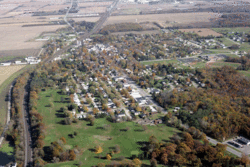
New Carlisle from the air, looking East | |
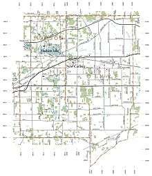
 Location of New Carlisle in the state of Indiana | |
| Coordinates: 41°42′15″N 86°30′17″W / 41.70417°N 86.50472°WCoordinates: 41°42′15″N 86°30′17″W / 41.70417°N 86.50472°W | |
| Country | United States |
| State | Indiana |
| County | St. Joseph |
| Township | Olive |
| Area[1] | |
| • Total | 2.09 sq mi (5.41 km2) |
| • Land | 2.09 sq mi (5.41 km2) |
| • Water | 0 sq mi (0 km2) |
| Elevation[2] | 810 ft (247 m) |
| Population (2010)[3] | |
| • Total | 1,861 |
| • Estimate (2012[4]) | 1,865 |
| • Density | 890.4/sq mi (343.8/km2) |
| Time zone | Eastern (EST) (UTC-5) |
| • Summer (DST) | EDT (UTC-4) |
| ZIP code | 46552 |
| Area code(s) | 574 |
| FIPS code | 18-52704[5] |
| GNIS feature ID | 452704 |
New Carlisle is a suburban town in Olive Township, St. Joseph County, in the U.S. state of Indiana.[6] The population was 1,861 at the 2010 Census. It is part of the South Bend–Mishawaka, IN-MI, Metropolitan Statistical Area.
History
New Carlisle was originally known as Bourissa Hills.[7] This was named after Lazarus Bourissa, a Potawatamie graduate of the Carey Mission who had been granted this section of land by the treaty that moved most of the Potawatamie to the west. It was platted under the name of New Carlisle, by Richard Risley Carlisle, who had come from Philadelphia, in 1835.[7] The New Carlisle post office has been in operation since 1837.[8]
The New Carlisle Historic District and Jeremiah Service House are listed on the National Register of Historic Places.[9]
Geography
New Carlisle is located at 41°42′15″N 86°30′17″W / 41.70417°N 86.50472°W (41.704134, -86.504636).[10]
According to the 2010 census, New Carlisle has a total area of 2.08 square miles (5.39 km2), all land.[1]
Town motto
"A nice place to visit, A great place to live" is written on the curve before the viaduct, and is taken as the town motto.
Demographics
| Historical population | |||
|---|---|---|---|
| Census | Pop. | %± | |
| 1880 | 530 | — | |
| 1890 | 607 | 14.5% | |
| 1900 | 597 | −1.6% | |
| 1910 | 612 | 2.5% | |
| 1920 | 609 | −0.5% | |
| 1930 | 718 | 17.9% | |
| 1940 | 747 | 4.0% | |
| 1950 | 983 | 31.6% | |
| 1960 | 1,376 | 40.0% | |
| 1970 | 1,434 | 4.2% | |
| 1980 | 1,439 | 0.3% | |
| 1990 | 1,446 | 0.5% | |
| 2000 | 1,505 | 4.1% | |
| 2010 | 1,861 | 23.7% | |
| Est. 2015 | 1,853 | [11] | −0.4% |
2010 census
As of the census[3] of 2010, there were 1,861 people, 719 households, and 520 families residing in the town. The population density was 890.4 inhabitants per square mile (343.8/km2). There were 795 housing units at an average density of 380.4 per square mile (146.9/km2). The racial makeup of the town was 96.0% White, 0.8% African American, 0.6% Native American, 0.4% Asian, 0.2% from other races, and 2.0% from two or more races. Hispanic or Latino of any race were 1.3% of the population.
There were 719 households of which 39.4% had children under the age of 18 living with them, 50.3% were married couples living together, 15.0% had a female householder with no husband present, 7.0% had a male householder with no wife present, and 27.7% were non-families. 23.6% of all households were made up of individuals and 9.1% had someone living alone who was 65 years of age or older. The average household size was 2.59 and the average family size was 3.04.
The median age in the town was 36.1 years. 28.2% of residents were under the age of 18; 8% were between the ages of 18 and 24; 25.2% were from 25 to 44; 26.8% were from 45 to 64; and 11.9% were 65 years of age or older. The gender makeup of the town was 47.9% male and 52.1% female.
2000 census
As of the census[5] of 2000, there were 1,505 people, 608 households, and 403 families residing in the town. The population density was 820.3 people per square mile (317.5/km²). There were 633 housing units at an average density of 345.0 per square mile (133.6/km²). The racial makeup of the town was 98.01% White, 0.47% African American, 0.33% Native American, 0.07% Asian, 0.33% from other races, and 0.80% from two or more races. Hispanic or Latino of any race were 1.13% of the population.
There were 609 households out of which 34.7% had children under the age of 18 living with them, 51.8% were married couples living together, 10.5% had a female householder with no husband present, and 33.6% were non-families. 28.3% of all households were made up of individuals and 12.0% had someone living alone who was 65 years of age or older. The average household size was 2.48 and the average family size was 3.07.
In the town the population was spread out with 28.0% under the age of 18, 7.0% from 18 to 24, 29.0% from 25 to 44, 21.5% from 45 to 64, and 14.5% who were 65 years of age or older. The median age was 36 years. For every 100 females there were 86.5 males. For every 100 females age 18 and over, there were 84.4 males.
The median income for a household in the town was $36,542, and the median income for a family was $45,147. Males had a median income of $37,500 versus $22,250 for females. The per capita income for the town was $18,597. About 4.1% of families and 6.6% of the population were below the poverty line, including 8.0% of those under age 18 and 6.4% of those age 65 or over.
Education
New Carlisle is home to three of five schools in the New Prairie United School Corporation. New Prairie High School has an enrollment of approximately 875 students and is one of 27 high schools that received exemplary status according to the scores of the 2006 ISTEP tests. It is the only school in LaPorte, Elkhart, and Marshall counties to receive this honor. The other schools in New Carlisle that are part of the NPUSC are New Prairie Middle School,and Olive Township Elementary School.
Transportation
The South Shore Line had a New Carlisle stop until 1994,[13] when a number of stations with low ridership were eliminated from its schedule. Today, the closest South Shore Line station is located in the nearby Hudson Lake, an unincorporated town in LaPorte County. The closest Amtrak station is located in South Bend, Indiana. While the South Bend public transit system served the town in the past, this has not been the case in decades.
Notable people
- Bill Doba: former head football coach at Washington State University
- Schuyler Colfax: was a Representative from Indiana and the 17th Vice President of the United States
- Dan Seemiller: 2000 and 2004 US Olympic men's table tennis coach, author of Winning Table Tennis: Skills, Drills, and Strategies.[14]
References
- 1 2 "G001 - Geographic Identifiers - 2010 Census Summary File 1". United States Census Bureau. Retrieved 2015-07-17.
- ↑ "US Board on Geographic Names". United States Geological Survey. 2007-10-25. Retrieved 2008-01-31.
- 1 2 "American FactFinder". United States Census Bureau. Retrieved 2012-12-11.
- ↑ "Population Estimates". United States Census Bureau. Retrieved 2013-06-25.
- 1 2 "American FactFinder". United States Census Bureau. Retrieved 2008-01-31.
- ↑ "New Carlisle, Indiana". Geographic Names Information System. United States Geological Survey. Retrieved 2016-11-06.
- 1 2 "New Carlisle: The Story Of Our Town". historicnewcarlisle.org. Retrieved 26 May 2015.
- ↑ "Saint Joseph County". Jim Forte Postal History. Retrieved November 6, 2016.
- ↑ National Park Service (2010-07-09). "National Register Information System". National Register of Historic Places. National Park Service.
- ↑ "US Gazetteer files: 2010, 2000, and 1990". United States Census Bureau. 2011-02-12. Retrieved 2011-04-23.
- ↑ "Annual Estimates of the Resident Population for Incorporated Places: April 1, 2010 to July 1, 2015". Retrieved July 2, 2016.
- ↑ "Census of Population and Housing". Census.gov. Retrieved June 4, 2015.
- ↑ Dodson, Paul (June 17, 1994). "South Shore Railroad Will Close 7 Flagstops". South Bend, IN: South Bend Tribune. p. B2.
- ↑ "Home - South Bend Table Tennis Center". sbttc.org. Retrieved 26 May 2015.
Municipalities and communities of St. Joseph County, Indiana, United States | ||
|---|---|---|
| Cities | ||
| Towns | ||
| Townships | ||
| CDPs | ||
| Unincorporated communities |
| |
| Footnotes | ‡This populated place also has portions in an adjacent county or counties | |