New Forest District
Coordinates: 50°52′44″N 1°37′59″W / 50.879°N 1.633°W
| New Forest New Forest District | |
|---|---|
| Non-metropolitan district | |
| Motto: "Old yet ever new" | |
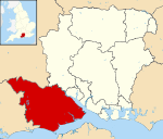
 New Forest shown within Hampshire | |
| Sovereign state | United Kingdom |
| Constituent country | England |
| Region | South East England |
| Non-metropolitan county | Hampshire |
| Status | Non-metropolitan district |
| Admin HQ | Lyndhurst |
| Incorporated | 1 April 1974 |
| Government | |
| • Type | Non-metropolitan district council |
| • Body | New Forest District Council |
| • Leadership | Leader and Cabinet (Conservative) |
| • MPs |
Julian Lewis Desmond Swayne |
| Area | |
| • Total | 290.8 sq mi (753.2 km2) |
| Area rank | 47th (of 326) |
| Population (mid-2014 est.) | |
| • Total | 178,907 |
| • Rank | 99th (of 326) |
| • Density | 620/sq mi (240/km2) |
| • Ethnicity |
94.9% White British 2.67% White Other 0.94% Asian 0.35% Black 1.14% Other |
| Time zone | GMT (UTC0) |
| • Summer (DST) | BST (UTC+1) |
| ONS code |
24UJ (ONS) E07000091 (GSS) |
| OS grid reference | SU2581608959 |
| Website |
www |
New Forest is a local government district in Hampshire, England. It is named after the New Forest.
It was created on 1 April 1974, and was a merger of the borough of Lymington, New Forest Rural District and part of Ringwood and Fordingbridge Rural District.
The district is one of the most populated in England not to be a unitary authority. It was recommended by the Banham Commission to become one in 1995, but this case was vetoed by the government of the day.
Parishes and settlements
- Ashurst and Colbury
- Beaulieu, Boldre, Bramshaw, Bransgore, Breamore, Brockenhurst, Burley
- Copythorne
- Damerham, Denny Lodge
- East Boldre, Ellingham Harbridge and Ibsley, Exbury and Lepe
- Fawley, Fordingbridge
- Godshill
- Hale, Hordle, Hyde, Hythe and Dibden
- Lymington, Lyndhurst
- Marchwood, Martin, Milford-on-Sea, Minstead
- Netley Marsh, New Milton
- Ringwood, Rockbourne
- Sandleheath, Sopley, Sway
- Totton and Eling
- Whitsbury, Woodgreen
This article is issued from Wikipedia - version of the 9/19/2016. The text is available under the Creative Commons Attribution/Share Alike but additional terms may apply for the media files.
