Lewes District
| Lewes District | |
|---|---|
| Non-metropolitan district | |
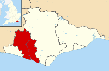 Lewes shown within East Sussex | |
| Sovereign state | United Kingdom |
| Constituent country | England |
| Region | South East England |
| Non-metropolitan county | East Sussex |
| Status | Non-metropolitan district |
| Admin HQ | Lewes |
| Incorporated | 1 April 1974 |
| Government | |
| • Type | Non-metropolitan district council |
| • Body | Lewes District Council |
| • Leadership | Leader & Cabinet (Conservative) |
| Area | |
| • Total | 112.74 sq mi (292.00 km2) |
| Area rank | 140th (of 326) |
| Population (mid-2014 est.) | |
| • Total | 100,229 |
| • Rank | 234th (of 326) |
| • Density | 890/sq mi (340/km2) |
| • Ethnicity | 97.9% White |
| Time zone | GMT (UTC0) |
| • Summer (DST) | BST (UTC+1) |
| ONS code |
21UF (ONS) E07000063 (GSS) |
| OS grid reference | TQ420104 |
| Website |
www |
Lewes is a local government district in East Sussex in southern England covering an area of 113 sq mi (290 km2), with 9 miles (14.5 km) of coastline.[1] It is named after its administrative centre, Lewes. Other towns in the district include Newhaven, Peacehaven, Seaford and Telscombe. Plumpton racecourse is within the district. There are 28 parishes in the district.
The district was formed on 1 April 1974 by the Local Government Act 1972, and was a merger of the former borough of Lewes along with Newhaven and Seaford urban districts and Chailey Rural District.
Politics
Elections to the council are held every four years, with all of the 41 seats, representing 21 wards, on the council being filled. After being controlled by the Liberal Democrats since 1991, the Conservative party regained a majority at the 2011 election.[2] Although, subsequent defections of Conservative councillors to UKIP [3][4] and the Liberal Democrats [5] left the council in no overall control. However, in the Council election on the 7th May 2015 the Conservatives regained control with an increased majority and heavy losses for the Liberal Democrats.[6] The current composition is as follows.
| Year | Conservative | Liberal Democrat | Green Party | Independent | UKIP |
|---|---|---|---|---|---|
| 2015 | 24 | 11 | 3 | 2 | 1 |
Geography
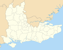
The district wards are:
| Ward | Population (2007) | Councillors | Ratio |
|---|---|---|---|
| Barcombe and Hamsey | 2021 | 1 | 2021 |
| Chailey and Wivelsfield | 4687 | 2 | 2344 |
| Ditchling and Westmeston | 2334 | 1 | 2334 |
| East Saltdean and Telscombe Cliffs | 7146 | 3 | 2382 |
| Kingston | 2095 | 1 | 2095 |
| Lewes Bridge | 4357 | 2 | 2179 |
| Lewes Castle | 4712 | 2 | 2356 |
| Lewes Priory | 7153 | 3 | 2384 |
| Newhaven Denton and Meeching | 8236 | 3 | 2745 |
| Newhaven Valley | 3790 | 2 | 1895 |
| Newick | 2343 | 1 | 2343 |
| Ouse Valley and Ringmer | 6579 | 3 | 2193 |
| Peacehaven East | 4325 | 2 | 2163 |
| Peacehaven North | 4772 | 2 | 2386 |
| Peacehaven West | 4171 | 2 | 2086 |
| Plumpton, Streat, East Chiltington and St John (Without) | 2391 | 1 | 2391 |
| Seaford Central | 4712 | 2 | 2356 |
| Seaford East | 4704 | 2 | 2352 |
| Seaford North | 4906 | 2 | 2453 |
| Seaford South | 4400 | 2 | 2200 |
| Seaford West | 4439 | 2 | 2220 |
| Total Lewes | 94723 | 41 | 2299 |
The civil parishes within the district are:
| Parish | Type | Population (2007) | Area (sq mi) | Pop Density /sq mi |
|---|---|---|---|---|
| Barcombe | Parish Council | 1447 | 6.9 | 211 |
| Chailey | Parish Council | 2728 | 9.6 | 284 |
| Ditchling | Parish Council | 2027 | 6.0 | 339 |
| East Chiltington & St John Without ‡ | Parish Council | 536 | 5.2 | 102 |
| Falmer & St Ann Without ‡ | Parish Council | 281 | 6.6 | 43 |
| Firle | Parish Council | 327 | 5.4 | 61 |
| Glynde and Beddingham & Tarring Neville ‡ | Parish Council | 555 | 9.8 | 57 |
| Hamsey | Parish Council | 574 | 4.4 | 130 |
| Iford | Parish Meeting | 205 | 3.7 | 55 |
| Kingston | Parish Council | 843 | 2.2 | 383 |
| Lewes | Town Council | 16222 | 4.4 | 3679 |
| Newhaven | Town Council | 12026 | 2.7 | 4375 |
| Newick | Parish Council | 2343 | 3.0 | 778 |
| Peacehaven | Town Council | 13268 | 2.0 | 6621 |
| Piddinghoe | Parish Council | 264 | 1.5 | 180 |
| Plumpton | Parish Council | 1676 | 3.7 | 450 |
| Ringmer | Parish Council | 4591 | 10.0 | 459 |
| Rodmell & Southease ‡ | Parish Council | 502 | 4.3 | 115 |
| Seaford | Town Council | 23161 | 6.7 | 3480 |
| South Heighton | Parish Council | 1106 | 3.3 | 338 |
| Streat | Parish Meeting | 179 | 2.0 | 89 |
| Telscombe | Town Council | 7146 | 1.8 | 3913 |
| Westmeston | Parish Council | 307 | 3.3 | 94 |
| Wivelsfield | Parish Council | 1959 | 4.2 | 470 |
| Total Lewes | 94273 | 112.7 | 836 |
‡ St John Without, St Ann Without, Tarring Neville and Southease are separate Parish Meetings but have been merged with their neighbouring parishes for the population statistics.
The Sussex Police has its head office in Lewes, Lewes District.[7]
The Prime Meridian passes through the district.
References
- ↑ "Lewes District Council: News and local information". Lewes District Council. 2009. Archived from the original on July 2, 2009. Retrieved 2009-08-12.
- ↑ http://www.bbc.co.uk/news/special/election2011/council/html/21uf.stm
- ↑ http://www.bloggers4ukip.org.uk/2013/01/lewes-cllr-donna-edmunds-defects-to-ukip.html
- ↑ http://www.bloggers4ukip.org.uk/2013/04/defection-leaves-tories-in-minority.html
- ↑ http://www.libdemvoice.org/former-tory-council-leader-joins-liberal-democrats-in-lewes-38792.html
- ↑ http://www.lewes.gov.uk/council/23219.asp
- ↑ "Non-emergency enquiries." (Archive) Sussex Police. Retrieved on 13 February 2011. "Sussex Police Headquarters Church Lane, Lewes East Sussex, BN7 2DZ."
Coordinates: 50°52′26″N 0°00′32″E / 50.87389°N 0.00889°E