Nobeoka, Miyazaki
| Nobeoka 延岡市 | ||
|---|---|---|
| City | ||
|
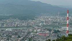
Panorama view of Agata and Nakashima, other downtown areas and the Ose River in Nobeoka, from Mount Atago | ||
| ||
 Location of Nobeoka in Miyazaki Prefecture | ||
 Nobeoka Location in Japan | ||
| Coordinates: 32°35′N 131°40′E / 32.583°N 131.667°ECoordinates: 32°35′N 131°40′E / 32.583°N 131.667°E | ||
| Country | Japan | |
| Region | Kyushu | |
| Prefecture | Miyazaki Prefecture | |
| Government | ||
| • Mayor | Masaharu Sudō | |
| Area | ||
| • Total | 867.97 km2 (335.13 sq mi) | |
| Population (December 1, 2013) | ||
| • Total | 128,187 | |
| • Density | 147.69/km2 (382.5/sq mi) | |
| Symbols | ||
| • Tree | Round Leaf Holly (Ilex rotunda) | |
| • Flower | Canna | |
| • Flowering tree | Wisteria | |
| Time zone | Japan Standard Time (UTC+9) | |
| City hall address |
2-1 Higashihonkōji, Nobeoka-shi, Miyazaki-ken 882-8686 | |
| Website |
www | |

Nobeoka (延岡市 Nobeoka-shi) is a city located in the north of Miyazaki Prefecture, Japan.
As of the December 1, 2013 the city has an estimated population of 128,187 and a population density of 147.68 persons per km². The total area is 867.97 km².
History
The city was officially founded on February 11, 1933 after it gained city status. During World War II it was one of the most important centers of military explosives in Japan.[1] On the night of June 28-29th, 1945, 117 United States B-29s fire-bombed the city destroying 1.35 square km, or 36% of the city.[2] On July 16, 1945, 33 US B-24s bombed the bridges in around the city, severing the strategically important Nippō Main Line railway.[3]
On February 20, 2006, Nobeoka absorbed the towns of Kitakata and Kitaura (both from Higashiusuki District).
On March 31, 2007, the town of Kitagawa (also from Higashiusuki District) was also merged into Nobeoka.
Climate
Nobeoka has a humid subtropical climate (Köppen climate classification Cfa), which is hot and humid in the summer (above 30 °C (86 °F)) and is somewhat cold in the winter with temperatures dropping to around freezing (0 °C (32 °F)). Snowfall can be seen in the winter months, but does not accumulate because of coastal warming effects.
| Climate data for Nobeoka, Miyazaki | |||||||||||||
|---|---|---|---|---|---|---|---|---|---|---|---|---|---|
| Month | Jan | Feb | Mar | Apr | May | Jun | Jul | Aug | Sep | Oct | Nov | Dec | Year |
| Average high °C (°F) | 12.2 (54) |
12.9 (55.2) |
15.8 (60.4) |
20.4 (68.7) |
23.5 (74.3) |
25.9 (78.6) |
29.9 (85.8) |
30.7 (87.3) |
28.1 (82.6) |
23.7 (74.7) |
19.0 (66.2) |
14.4 (57.9) |
21.38 (70.48) |
| Daily mean °C (°F) | 6.1 (43) |
7.1 (44.8) |
10.1 (50.2) |
15.1 (59.2) |
18.7 (65.7) |
21.9 (71.4) |
25.7 (78.3) |
26.4 (79.5) |
23.3 (73.9) |
18.1 (64.6) |
13.0 (55.4) |
8.0 (46.4) |
16.13 (61.03) |
| Average low °C (°F) | 1.0 (33.8) |
2.0 (35.6) |
4.8 (40.6) |
10.2 (50.4) |
14.2 (57.6) |
18.4 (65.1) |
22.4 (72.3) |
22.8 (73) |
19.6 (67.3) |
13.4 (56.1) |
7.9 (46.2) |
2.7 (36.9) |
11.62 (52.91) |
| Average precipitation mm (inches) | 56.0 (2.205) |
77.2 (3.039) |
134.8 (5.307) |
231.2 (9.102) |
275.8 (10.858) |
358.1 (14.098) |
259.9 (10.232) |
279.0 (10.984) |
307.1 (12.091) |
182.7 (7.193) |
79.2 (3.118) |
42.4 (1.669) |
2,283.4 (89.896) |
| Average relative humidity (%) | 62 | 64 | 66 | 73 | 77 | 83 | 83 | 82 | 81 | 75 | 71 | 66 | 73.6 |
| Mean monthly sunshine hours | 193.1 | 170.0 | 185.0 | 170.9 | 179.4 | 144.4 | 199.5 | 206.9 | 158.5 | 178.6 | 174.1 | 187.2 | 2,147.6 |
| Source: NOAA (1961-1990)[4] | |||||||||||||
Economy
The city's economy depends strongly on the company Asahi Kasei, a producer of synthetic and industrial fibers. It is known regionally for its Ayu fish.

Transportation
Nobeoka is the terminal station for trains that run the length of the prefecture (although some trains do continue up into Oita prefecture). It used to be the terminal station for the privately owned Takachiho line, which ran towards Kumamoto prefecture from the northeast to the northwest of the prefecture. This line was closed after a typhoon in 2005, and has not been reopened.
Nobeoka is serviced by the Higashikyushu Expressway which brings transportation time to Miyazaki City down to one hour and travel time to Oita City down to about 1 hour 30 minutes.
Nobeoka has its own municipal bus service with routes to most destinations in the city.
See also
Strategic bombing during World War II
References
- "Japs Disperse War Plants" , The Argus, Melbourne, June 30, 1945.
External links
- Nobeoka City official website (Japanese)
- Nobeoka City official website (English)
| Core city | |
|---|---|
| Cities | |
| Higashimorokata District | |
| Higashiusuki District | |
| Kitamorokata District | |
| Koyu District | |
| Nishimorokata District | |
| Nishiusuki District | |