North Carolina Highway 33
| ||||
|---|---|---|---|---|
|
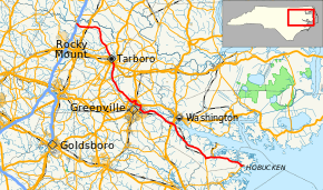
Route of NC 33 highlighted in red | ||||
| Route information | ||||
| Maintained by NCDOT | ||||
| Length: | 109.6 mi[1] (176.4 km) | |||
| Existed: | 1929 – present | |||
| Major junctions | ||||
| West end: |
| |||
|
| ||||
| East end: | Hobucken School Road in Hobucken | |||
| Location | ||||
| Counties: | Nash, Edgecombe, Pitt, Beaufort, Pamlico | |||
| Highway system | ||||
| ||||

North Carolina Highway 33 (NC 33) is a moderately lengthy state highway in the U.S. state of North Carolina. Spanning a distance of 110 miles (180 km), the east–west route passes through many small towns and communities in Eastern North Carolina's Inner Banks. It bypasses a large portion of the cities of Greenville and Rocky Mount, and goes through central Tarboro.
Route description
Pamlico area
The route's eastern terminus is at the same location as North Carolina Highway 304's northern terminus in rural Pamlico County, North Carolina. Both routes terminate in the community of Hobucken on Goose Creek Island, near Mesic.
From the terminus, NC 33 travels west, along with NC 304 southbound across the Intracoastal Waterway (Goose Creek), entering the Goose Creek Game Land. After crossing the bridge, the two state highways split. NC 33 continues in a northwesterly direction across the Gum Swamp out of Pamlico County and into Beaufort County. Veering due west, the route enters the town of Aurora where it joins NC 306 for a three-mile (5 km) concurrency. West of Aurora, the routes split; NC 33 darts northwest again on a route that parallels the Pamlico River. Entering the town of Chocowinity, NC 33 crosses US 17 (which northbound, crosses the Pamlico River into Washington) on its way into Pitt County.
Greenville area
In Pitt County, the route passes through Grimesland before darting west, just passing by the town of Simpson, on its way into Greenville. In the city, the route bears right onto Greenville Boulevard (US 264 Alt), heading north to meet mainline US 264, which bypasses the city to the north. At the junction, NC 33 turns west to head through northern Greenville, sharing a short 0.25-mile (0.40 km) concurrency with US 13/NC 11/903 before meeting the US 264 freeway (Greenville Bypass) again west of the city.
Tarboro area
Continuing northwest out of the Greenville area, NC 33 passes by the eastern terminus of NC 222 and enters Edgecombe County, where the route meets the US 64 south of Princeville. Entering the Princeville area, NC 33 joins US 64A for a short segment, crosses US 258/NC 111/122, and passes over the Tar River into the heart of Tarboro. Heading northeast, the state highway exits Tarboro and meets a junction with NC 97 in Leggett.
Rocky Mount area
Moving into northern Edgecombe County, the route orbits around the city of Rocky Mount, bypassing it, and turning west to meet US 301 in Whitakers after crossing the Nash County line. After a short concurrency with US 301 southbound in the small town, NC 33 heads west for its final stretch, crossing Interstate 95 (exit 150) before ending at North Carolina Highway 4/48. The terminus is located north of Dortches and Rocky Mount, southwest of Enfield, and northeast of Red Oak.
History
NC 33 was first created in 1929 or 1930 as a spur of parent route NC 30 that ran from Chocowinity to Aurora. It was extended between 1936 and 1938 through Washington as an alternative routing to NC 11. Around 1948-1953, the route's eastern terminus was moved to its current location at Hobucken. Throughout the 1970s, NC 33 was moved in the Washington area and extended through Greenville, taking the place of the old US 264 and NC 30 alignments in the area. In 1994, the final extension occurred during the Tarboro renumbering; the new alignment passed through Tarboro and then picked up the former NC 44's routing through Whitakers to end at NC 4/48.
Major intersections
| County | Location | mi[1] | km | Destinations | Notes |
|---|---|---|---|---|---|
| Nash | Whitakers | 0.0 | 0.0 | Western terminus | |
| 0.3 | 0.48 | Diamond interchange; I-95 exit 150 | |||
| 5.3 | 8.5 | West end of US 301 overlap | |||
| 5.5 | 8.9 | East end of US 301 overlap | |||
| Edgecombe | Leggett | 18.8 | 30.3 | ||
| Princeville | 26.4 | 42.5 | West end of US 64 Alt overlap | ||
| 27.4 | 44.1 | East end of US 64 Alt overlap | |||
| 27.8 | 44.7 | Diamond interchange | |||
| Old Sparta | 33.3 | 53.6 | |||
| Pitt | | 40.9 | 65.8 | ||
| Greenville | 45.3 | 72.9 | Diamond interchange | ||
| 48.7 | 78.4 | West end of US 13 / NC 11 / NC 903 overlaps | |||
| 49.0 | 78.9 | East end of US 13 / NC 11 / NC 903 overlaps | |||
| 52.3 | 84.2 | West end of US 264 Alt. overlap | |||
| 54.2 | 87.2 | East end of US 264 Alt. overlap | |||
| Beaufort | Chocowinity | 70.0 | 112.7 | ||
| 70.6 | 113.6 | Partial cloverleaf interchange | |||
| Aurora | 91.7 | 147.6 | West end of NC 306 overlap | ||
| 94.9 | 152.7 | East end of NC 306 overlap | |||
| Pamlico | | 108.1 | 174.0 | West end of NC 304 overlap | |
| Hobucken | 109.6 | 176.4 | Hobucken School Road | North end of NC 304 overlap | |
1.000 mi = 1.609 km; 1.000 km = 0.621 mi
| |||||
See also
- North Carolina Bicycle Route 2 - concurrent with NC 33 from Old Sparta (NC 42) to Belvoir Crossroads
- North Carolina Bicycle Route 3 - concurrent with NC 33 along the NC 306 concurrency
References
- 1 2 Google (November 23, 2013). "North Carolina Highway 33" (Map). Google Maps. Google. Retrieved November 23, 2013.
External links
-
 Media related to North Carolina Highway 33 at Wikimedia Commons
 - NCRoads.com: N.C. 33