North York City Centre
| North York City Centre | |
|---|---|
| Neighbourhood | |
|
North York City Centre, looking north along Yonge Street | |
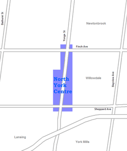 |

North York City Centre, sometimes known as Downtown North York,[1] is a city centre in Toronto, Ontario, Canada in the district of North York. Located within the official neighbourhood of Willowdale along Yonge Street, between Sheppard and Finch Avenues, the city centre was developed following the opening of the eponymous rapid transit station by the former city of North York, where many corporate headquarters were located. Following the amalgamation of North York by the City of Toronto Act amendment in 1997, North York City Centre became the largest of four central business districts in the city outside Downtown Toronto.[2]
History
The area along Yonge Street, between Sheppard and Finch Avenues, was chosen by Mel Lastman, former mayor of North York, to be developed into a central business district. Lastman was inspired by developments in Scarborough City Centre following the completion of the Scarborough line, and convinced the Toronto Transit Commission to construct North York Centre, an infill station completed in 1987 on the Yonge–University line. An official plan by the former Municipality of Metropolitan Toronto encouraged high-density commercial and residential developments in the area.
Landmarks
The city centre is directly served by North York Centre station, while Sheppard-Yonge and Finch stations are located south and north of the area, respectively. The North York Civic Centre and Mel Lastman Square, on the west side of Yonge Street, are central to the area. The Empress Walk is a major shopping mall. The station serves Earl Haig Secondary School, North York Central Library, and the Toronto Centre for the Arts are all located in the area. Gibson House, a museum converted from a mid-19th-century house built by the Canadian politician David Gibson, a Scottish immigrant, land surveyor and participant of the Rebellion of 1837, is also located in this neighbourhood.
References
Coordinates: 43°46′08″N 79°24′47″W / 43.769°N 79.413°W