Downtown Jacksonville
| Downtown Jacksonville | |
|---|---|
| Neighborhood of Jacksonville | |
 | |
 Downtown Jacksonville Central Jacksonville | |
| Coordinates: 30°19′40″N 81°39′36″W / 30.32764°N 81.66012°W | |
| Government | |
| • City Council |
Don Redmon, Warren A. Jones, Dr. Johnny Gaffney |
| • State Assembly | Reggie Fullwood |
| • State Senate | Audrey Gibson |
| • U.S. House | Corrine Brown (D) |
| Area | |
| • Total | 5 km2 (1.9 sq mi) |
| • Land | 5 km2 (1.9 sq mi) |
| Population (2011) | |
| • Total | 3,200 |
| • Density | 641/km2 (1,684/sq mi) |
| ZIP Code | 32202,32207 |
| Area code(s) | 904 |
| Website | downtownjacksonville.com |
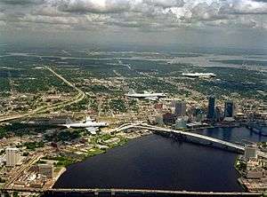
Downtown Jacksonville is the historic core and central business district (CBD) of Jacksonville, Florida USA. It comprises the earliest area of the city to be developed and is located in its geographic center along the narrowing point of the St. Johns River. There are various definitions of what constitutes Jacksonville's downtown; the one used by the city government and other entities defines it as including five districts: the Downtown Core (or Northbank), the Southbank, LaVilla, Brooklyn, and the Sports Complex. The area features offices for major corporations such as CSX Corporation, Fidelity National Financial, EverBank, Bank of America, Prudential Financial, Wells Fargo, AT&T, and Aetna.
Area
Multiple definitions of Downtown Jacksonville are in common use. Often, the name "Downtown" is used exclusively for the historical core. This is bounded roughly by State Street to the north, Hogans Creek to the east, the St. Johns River to the south, and the LaVilla neighborhood to the west. This definition is used, for example, by the Jacksonville Historic Preservation Commission and their book, Jacksonville's Architectural Heritage.[1] However, the City of Jacksonville and other entities use a wider definition that includes not only the Downtown Core (also known as the Northbank), but surrounding areas on both sides of the river. In this definition, the boundaries are State Street to the north, the St. Johns River to the east, and Interstate 95 to the south and west.[2] This area covers 1,234 acres (499 ha; 1.928 sq mi).[3] Downtown Vision, Inc., which oversees Jacksonville's downtown improvement district, covers an even smaller area of about 90 blocks in the Downtown Core and Southbank, bounded by Church Street in the north, Market Street in the east, Prudential Drive in the south, and Broad Street in the west.[2]
Under the broader definition, Downtown Jacksonville is divided into several districts or neighborhood. In addition to the historical Downtown Core, the most commonly used districts are: the Southbank, a commercial and residential district directly across the St. Johns River from the Downtown Core; LaVilla, a historically African American neighborhood west of the Downtown Core; Brooklyn, to the southwest of the Downtown Core; and the Stadium District, an area containing the city's major sports and entertainment venues to the east of the Downtown Core.[4]
Downtown Core

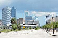
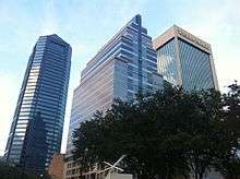
The Downtown Core, also known as the Northbank, is Jacksonville's traditional city center and what most people associate with Downtown and Jacksonville in general. It is the location of many government offices, including City Hall, the Jacksonville Sheriff's Office headquarters, and the Bryan Simpson United States Courthouse, and amenities such as the Jacksonville Main Library, the Museum of Contemporary Art Jacksonville, the Jacksonville Landing, and Jacksonville Riverwalk. Several of the city's largest skyscrapers are located there, such as the Bank of America Tower, the Wells Fargo Center, EverBank Center, and the SunTrust Tower, and are home to some of the city's major employers, such as EverBank and CSX Corporation.
The Downtown Core is sometimes further divided into additional, smaller districts. Downtown Vision, Inc. refers to the blocks to north of Church Street and west of Liberty Street as the "Downtown Periphery".[5] The City of Jacksonville's Downtown Master Plan further restricts the "Central Civic Core" to south of Church Street and east of Main Street, separating the rest of the area into other districts.[6]
The Cathedral District is located in the northeast corner, near Hogans Creek.[7] This mixed-used neighborhood is home to many of Jacksonville's landmark churches, including St. John's Episcopal Cathedral, the Mount Zion AME Church, Immaculate Conception Catholic Church, First Presbyterian Church, and the First United Methodist Church. Due to the area's close proximity to the former courthouse many of the residential structures have been converted into attorneys' offices.[8]
The Riverfront District, also known as the East Bay Street District and other names, exists in the southwest corner of the Downtown Core, centered on East Bay Street. This area was historically industrial before the abandonment of the Jacksonville Shipyards and related industries.[9] The city subsequently zoned much of the area for entertainment, commercial, and residential uses, creating the "Bay Street Entertainment Zone" on Bay Street. In 2011 the entertainment zoning was rebranded the "E-Town Zone" and expanded to include parts of Ocean, Adams and Forsyth Streets, covering much of the historical East Bay Street District.[10][11]
Southbank
Southbank is a mixed commercial and residential district on the southern shore of the St. Johns River, directly across from the Northbank. It is closely associated with (and sometimes considered part of) Jacksonville's San Marco neighborhood. It includes large office towers such as the Aetna Building, Riverplace Tower, and Baptist Medical Center. Residential towers include The Peninsula, The Strand, and San Marco Place. There are six major hotels on the Southbank, including Crowne Plaza Jacksonville Riverfront and Wyndham Jacksonville Riverwalk as well as amenities such as the Museum of Science and History, Friendship Fountain and the Southbank Riverwalk. Though historically poorly designed for pedestrians, the city hopes to better integrate it with the rest of Downtown as well as San Marco.[11][12]
LaVilla
LaVilla is a district immediately west of the Downtown Core. Jacksonville's first suburb, the predominantly African-American neighborhood was an independent municipality until being annexed in 1887. The area of the neighborhood north of Adams Street emerged as a mecca of African-American culture, and was home to many venues showcasing black performers, such as the Ritz Theatre. The southern part of the neighborhood was a major railroad hub and was also Jacksonville's chief red light district for a period.[13]
The neighborhood went into serious decline in the 1960s, and has not recovered. Urban renewal projects commenced in the 1980s, resulting in the loss of many buildings. More recent projects have aimed at bringing commercial development and public amenities to the area.[11][13][14][15]
Brooklyn
Brooklyn is located at the far southwestern corner of downtown. It comprises the area south of Lavilla and north and west of Interstate 95. Originally a residential suburb, it was annexed into Jacksonville in 1887. It is connected to Jacksonville's Riverside neighborhood by Riverside Avenue. It is home to Fidelity National Financial, EverBank, and FIS corporate headquarters, and other offices.
Commercial and industrial uses became prominent in the 20th century, and many commercial office buildings were constructed along the river. Subsequently, a rift emerged between the office-centered part of the neighborhood on the river and the traditional neighborhood further inland. As a result, in the 21st century the city re-introduced residential zoning and the neighborhood has become the site of mixed-use developments.[11][16][17][18]
Stadium District
The Stadium District, also known as the Sports Complex, is located east of the Downtown Core, and contains Jacksonville's major sporting and entertainment venues. Historically part of Jacksonville's Eastside, it is home to EverBank Field, the Baseball Grounds of Jacksonville, Jacksonville Veterans Memorial Arena, Metropolitan Park, and the Greater Jacksonville Fair and Expo Center.[11][19] The Gator Bowl Stadium was razed in 1994.
History
._Surveyed_April_1864._(Signed)_Wm._H._Dennis%2C_U._S...._-_NARA_-_305631.jpg)
The site of modern Downtown Jacksonville originated at a crossing of the St. Johns River known to the Seminole as Wacca Pilatka, to the Spanish as the Pass de San Nicolas, and to later British settlers as the Cow Ford. Histories of the city report that there was once an Indian village at the site called Ossachite. White settlement in the area began during Florida's British period (1763–1783), when the East Florida government built the King's Road to connect St. Augustine with the British colonies to the north. A ferry and tavern were built, and when Spanish rule resumed in Florida, Fort San Nicolas was built beside the southern landing of the King's Road ferry. American farmer Robert Pritchard became the first white settler on the north bank of the Cow Ford when he received a 450-acre land grant from the Spanish government in 1791, however, he died shortly after and the area was abandoned.[1]
The settlement that became Jacksonville largely formed from two land grants issued in 1816: one to Maria Taylor, née Suarez, and one to Juan LeMaestre. Over time a small settlement including some homes, an inn and a store grew at the Cow Ford, and in 1822, shortly after Spain ceded the Floridas to the United States, resident Isaiah D. Hart proposed establishing a town on the north bank. Hart eventually convinced his neighbors to join him in donating land for the venture, and the first streets were platted in June. The settlement was named "Jacksonville" after Andrew Jackson, who had become popular among many Floridians for his actions in the First Seminole War. It was incorporated in 1832.[1]
The town grew in fits and starts: it saw disruption during the Second Seminole War (1835–1842), and the business district burned down in 1854 when sparks from the steamboat Florida started a fire. During the American Civil War, Jacksonville was home to many Union sympathizers, and was occupied for most of the war by Union troops who took the city four separate times. The war devastated Jacksonville and caused over half the population to flee. After the war, the city rebounded quickly when it became Florida's first major tourist destination; though tourism declined by the late 1880s growth and industry continued apace through the late 19th century.[1]
On May 3, 1901, downtown Jacksonville was ravaged by a fire that started at a fiber factory. Known as the Great Fire of 1901, it was one of the worst disasters in Florida history and the largest urban fire in the southeastern United States. In just eight hours, it destroyed the business district and left approximately 10,000 residents homeless. Architect Henry John Klutho was a primary figure in the reconstruction of the city.
Transportation
Downtown Jacksonville transportation options include bus, monorail, water taxi, as well as major roadways.
Public transportation
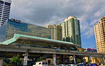
Downtown is served by the Jacksonville Transportation Authority's zero-fare automated people mover system (known as the "Skyway") and an extensive bus network.[20] The Skyway has the following stations:
Current Skyway Stations[21]
- Rosa L. Parks/FSCJ located at the northern most extent of downtown, serving Florida State College at Jacksonville and the neighborhood of Springfield.
- Hemming Plaza at Hogan Street & Duval Street, serving City Hall, U.S. Federal Courthouse, and Main Library.
- Central at Hogan Street & Bay Street, serving EverBank Center, Omni Hotel, Jacksonville Landing, Bank of America Tower, and BB&T Tower.
- Jefferson at Jefferson Street & Bay Street, serving the Federal Reserve Building and Courthouse.
- Convention Center on Bay Street serving the Prime F. Osborn III Convention Center.
- San Marco near the Acosta Bridge on San Marco Blvd. It serves the Museum of Science and History, Baptist Medical Center, and the Prudential Building.
- Riverplace on Flagler Ave services Riverplace Tower.
- Kings Avenue at Kings Ave & Prudential Dr and is the southern terminus of the Skyway
Downtown is also home to Greyhound's Jacksonville bus terminal.
Highways
Major roadways serving Downtown from the suburbs include (I-10) from Baldwin, (I-95) North from the airport area, (I-95) South from St. Augustine, Arlington Expressway from the Beaches, and the Hart Expressway from the Southside area. Other important roadways are U.S. Route 1, U.S. Route 17, and U.S. Route 90. Downtown is also the southern terminus of U.S. Route 23.
Bridges

Jacksonville is nicknamed "The River City". Historically, life in the city existed around the economic activity along the shores of the St. Johns River. Downtown lies on a portion of river that narrows before it empties out into the Atlantic Ocean. The areas strategic location makes it home to a high concentration of bridges. Just in Downtown, there are 5 bridges (listed below) connecting the two halves of Duval County.
Surrounding neighborhoods
- Springfield
- Eastside
- Arlington
- St. Nicholas
- San Marco
- Riverside and Avondale
- Mixon Town
- New Town
- Durkeeville
Major buildings
The 14 tallest standard structures
| Std. rank |
Name | Year |
Location (Downtown) |
Floors |
Standard height ft |
Std. hgt m |
Notes |
|---|---|---|---|---|---|---|---|
| 1 |
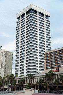
Bank of America Tower | 1990 | North Laura Street & West Bay Street | 42 | 617 | 188 | [22][23] |
| 2 |
Wells Fargo Center | 1974 | Laura Street & Independent Drive | 37 | 535 | 163 | |
| 3 |
EverBank Center | 1983 | West Bay Street & Pearl Street | 32 | 447 | 136 | |
| 4 |
The Peninsula at St. Johns Center | 2006 | 1401 Riverplace Boulevard | 36 | 437 | 133 | |
| 5 |
Riverplace Tower | 1967 | Riverplace Boulevard & Flagler Avenue | 28 | 432 | 132 | |
| 6 |
SunTrust Tower | 1989 | Laura Street & Independent Drive | 24 | 357 | 109 | |
| 7 |
The Strand at St. Johns Center | 2006 | 1401 Riverplace Boulevard | 28 | 328 | 100 | |
| 8 |
Aetna Building | 1954 | 841 Prudential Drive | 22 | 309 | 94 | |
| 9 |
Two Prudential Plaza | 1985 | Museum Circle & San Marco Boulevard | 21 | 305 | 93 | |
| 10 |
One Enterprise Center | 1986 | Water & Hogan Streets | 21 | 299 | 91 | |
| 11 |
Blue Cross Blue Shield Building | 1971 | Riverside Avenue & Edison Street | 19 | 287 | 87 | |
| 12 |
BB&T Building | 1974 | West Forsyth & Hogan Streets | 18 | 278 | 85 | |
| 13 |
John Milton Bryan Simpson United States Courthouse | 2002 | West Duval & Hogan Streets | 15 | 277 | 84 | |
| 14 |
JEA Tower | 2005 | West Church & Main Streets | 19 | 268 | 82 |
Hotels
The following hotels are located in the downtown Jacksonville area:
- Crowne Plaza Jacksonville Riverfront
- Extended Stay America Jacksonville Central
- Hampton Inn Jacksonville Downtown
- Hilton Garden Inn Jacksonville Downtown
- Homewood Suites Jacksonville Downtown Southbank
- Hyatt Regency Jacksonville Riverfront
- Omni Jacksonville Hotel
- Wyndham Jacksonville Riverwalk
Parks and plazas
Downtown is home to numerous parks, large and small:
- Treaty Oak Park
- Hemming Plaza
- Metropolitan Park
- Friendship Fountain
- Brooklyn Park
- Courthouse Lawn
- Plaza at EverBank Center
- Northbank Riverwalk
- Southbank Riverwalk
Attractions

- Jacksonville Landing
- EverBank Field
- Baseball Grounds of Jacksonville
- Jacksonville Veterans Memorial Arena
- Prime F. Osborn III Convention Center
- Museum of Contemporary Art Jacksonville
- Jacksonville Maritime Museum
- Museum of Science and History
- Jacksonville Fire Museum
- Ritz Theatre & Museum
- Florida Theatre
- Times-Union Center for the Performing Arts
See also
References
- 1 2 3 4 Wood, Wayne (1992). Jacksonville's Architectural Heritage. University Press of Florida. pp. 22–29. ISBN 0-8130-0953-7.
- 1 2 "Who We Are". downtownjacksonville.org. Downtown Vision, Inc. Retrieved December 18, 2012.
- ↑ "The State of Downtown: 2011 Progress Report". Downtown Vision, Inc. 2011. p. 2. Retrieved December 20, 2012.
- ↑ "Celebrating the River: A Plan for Downtown Jacksonville" (PDF). www.coj.net. City of Jacksonville. 2000. Retrieved December 20, 2012.
- ↑ "The State of Downtown: 2011 Progress Report". Downtown Vision, Inc. 2011. p. 26. Retrieved December 20, 2012.
- ↑ "Celebrating the River: A Plan for Downtown Jacksonville" (PDF). www.coj.net. City of Jacksonville. 2000. pp. 26–27. Retrieved December 20, 2012.
- ↑ "Downtown Jacksonville Master Plan". City Of Jacksonville. Retrieved 2012-12-14.
- ↑ "Exploring Downtown's Cathedral District". Metro Jacksonville. Retrieved 2012-12-14.
- ↑ "Remembering The East Bay Street District". Metro Jacksonville. Retrieved 2013-09-02.
- ↑ "Celebrating the River: A Plan for Downtown Jacksonville" (PDF). www.coj.net. City of Jacksonville. 2000. p. 33. Retrieved December 20, 2012.
- 1 2 3 4 5 06/08/2011 (2011-06-08). "In the zone: JEDC wants to expand Bay Street entertainment area". Jaxdailyrecord.com. Retrieved 2013-09-02.
- ↑ "Celebrating the River: A Plan for Downtown Jacksonville" (PDF). www.coj.net. City of Jacksonville. 2000. pp. 34–35. Retrieved December 20, 2012.
- 1 2 Wood 1992, pp. 86–89
- ↑ "History of LaVilla". Retrieved 2012-09-16.
- ↑ "Celebrating the River: A Plan for Downtown Jacksonville" (PDF). www.coj.net. City of Jacksonville. 2000. pp. 22–23. Retrieved December 20, 2012.
- ↑ "Celebrating the River: A Plan for Downtown Jacksonville" (PDF). www.coj.net. City of Jacksonville. 2000. pp. 20–21. Retrieved February 21, 2013.
- ↑ "History of Brooklyn". Retrieved 2012-09-16.
- ↑ "Celebrating the River: A Plan for Downtown Jacksonville" (PDF). www.coj.net. City of Jacksonville. 2000. pp. 2–21. Retrieved December 20, 2012.
- ↑ "Celebrating the River: A Plan for Downtown Jacksonville" (PDF). www.coj.net. City of Jacksonville. 2000. pp. 31–32. Retrieved December 20, 2012.
- ↑ "Downtown Jacksonville: Skyway" (website). Retrieved 2012-09-16.
- ↑ "JTA Downtown Map". Retrieved 2012-09-16.
- ↑ "Bank of America Tower". SkyscraperPage.com. Retrieved 7 Dec 2008. External link in
|publisher=(help) - ↑ "Bank of America Tower, Jacksonville Florida". Portfolio — Current Properties. Parameter Realty Partners. Retrieved 7 Dec 2008.
External links
Coordinates: 30°19′10″N 81°39′36″W / 30.3194°N 81.6600°W
| ||
