Laurentian Divide

The Laurentian Divide or Northern Divide is a continental divide in North America dividing the direction of water flow in eastern and southern Canada from that of the northern Midwestern United States. The Laurentian Divide separates the river systems that flow northwards to the Arctic Ocean and Hudson Bay from those that flow southwards to the Atlantic Ocean, Caribbean Sea and Gulf of Mexico. The Laurentian Divide runs from its junction with the Great Divide at Triple Divide Peak in Glacier National Park in Montana, and terminates at Cape Chidley on the Labrador Sea.
Geography
A continental divide is a drainage divide such that the drainage basin on one side of the divide feeds into one ocean or sea, and the basin on the other side either feeds into a different ocean or sea. In the Laurentian Divide, water north of the height of land flows to the Arctic Ocean by rivers to Hudson Bay or directly to the Arctic. Water south of the divide makes its way to the Atlantic Ocean by a variety of streams, including the Great Lakes and Saint Lawrence River to the east, and the Mississippi River to the Gulf of Mexico to the south. Many sources[1][2][3] consider Hudson Bay to be part of the Atlantic Ocean, not the Arctic, which would make the Laurentian Divide a lesser divide between the seas of one ocean.[4]
Course
On the northeast, the divide's terminus is at Cape Chidley's Killiniq Island, on the Labrador Sea where that sea meets Hudson Strait, which connects to Hudson Bay. It cuts through eastern Canada, dips into the United States, and re-enters Canada before terminating in the Rocky Mountains in the western United States.
On Killiniq Island, the divide forms the boundary between Labrador and Nunavut, then a good portion of the Labrador-Quebec border. It turns west to cross central Quebec and Ontario; it marks the original northern boundary that both provinces held at the time of Confederation in 1867, although both have since expanded significantly northward. Waters east and south of the divide flow into the Labrador Sea, the Gulf of St. Lawrence, or the Saint Lawrence River and the Great Lakes which are drained by that river.
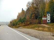
The divide crosses into the United States in northeast Minnesota at the Height of Land Portage. Near Hibbing it forms a three-way divide at the Hill of Three Waters (47°28′19″N 92°57′56″W / 47.47184°N 92.96549°W)[5][6][7] where the watersheds of the St. Lawrence and the Mississippi River systems meets with the Hudson Bay basin. It crosses Minnesota and enters South Dakota at the Traverse Gap, thence enters and passes through North Dakota[8] to that state's northwestern corner. The U.S. sections of the divide separate the watersheds of the Rainy River and Red River of the North from the Mississippi River basin. The divide formed the northern boundary of the United States' Louisiana Purchase.
The divide crosses the southern parts of Saskatchewan and Alberta before dropping back into the United States where it meets the Great Divide at Triple Divide Peak in Glacier National Park in Montana. The Laurentian Divide's western terminus is here, but the watershed boundaries continue. The Arctic watershed's limit follows the Great Divide running north, forming part of the Alberta-B.C. border, entering the interiors of B.C. and Yukon, forming two segments of the Yukon-Northwest Territories border, eventually crossing into northern Alaska, through to that state's Lisburne Peninsula and the sea.
References
- ↑ Canada's watersheds, The Canadian Atlas Online
- ↑ The North Saskatchewan River, Great Canadian Rivers
- ↑ Sanford, Robert W. (2010). Our World's Heritage: Creating a Culture Worthy of Place in Canada's Western Mountain Parks. Athabasca University Press. p. 160. ISBN 9781897425572.
- ↑ Michael Pidwirny (2006). "Introduction to the Oceans". www.physicalgeography.net. Archived from the original on 9 December 2006. Retrieved 2006-12-07.
- ↑ Gonzalez, Mark A. (2003). "Continental Divides in North Dakota and North America" (PDF). North Dakota Geological Survey Newsletter. 30 (1): 5.
- ↑ L, Keith. "Hill of Three Waters or the Triple Divide". Historical Marker Database, HMdb.org. Retrieved 17 June 2011.
- ↑ "7 km NE of Hibbing, Minnesota, United States 7/1/1983". Microsoft Research Terraserver. USGS. Retrieved 17 June 2011.
See USGS map sheet "Hibbing Quadrangle", Minnesota-St. Louis county, 7.5 minute series, a marker is located at point labeled "three way watershed marker", a point on the hill about 375 meters south of the truck shop on the property of Hibbing Taconite Iron ore mining company.
- ↑ "Continental Divides in North Dakota and North America". NationalAtlas.gov. Retrieved 2010-12-01.
External links
- U.S. Geological Survey Geographic Names Information System: Laurentian Divide (Minnesota portion)