Norwich (CDP), Vermont
| Norwich, Vermont | |
|---|---|
| Census-designated place | |
_highlighted.svg.png) Location in Windsor County and the state of Vermont. | |
| Coordinates: 43°42′55″N 72°18′31″W / 43.71528°N 72.30861°WCoordinates: 43°42′55″N 72°18′31″W / 43.71528°N 72.30861°W | |
| Country | United States |
| State | Vermont |
| County | Windsor |
| Area | |
| • Total | 1.5 sq mi (3.8 km2) |
| • Land | 1.5 sq mi (3.8 km2) |
| • Water | 0.0 sq mi (0.0 km2) |
| Elevation | 537 ft (164 m) |
| Population (2010) | |
| • Total | 878 |
| • Density | 600/sq mi (230/km2) |
| Time zone | Eastern (EST) (UTC-5) |
| • Summer (DST) | EDT (UTC-4) |
| ZIP code | 05055 |
| Area code(s) | 802 |
| FIPS code | 50-52825[1] |
| GNIS feature ID | 1458786[2] |
Norwich is a census-designated place (CDP) that comprises the central village of the town of Norwich, Windsor County, Vermont, United States. As of the 2010 census, the population of the CDP was 878,[3] compared to 3,414 for the entire town of Norwich.
Geography
Norwich is located in northeastern Windsor County. U.S. Route 5 passes through the village, connecting with Thetford to the north and White River Junction to the south. Interstate 91 forms the eastern edge of the CDP, with access to the village at Exit 13. Vermont Route 10A leads east from Exit 13 across the Connecticut River to Hanover, New Hampshire.
References
- ↑ "American FactFinder". United States Census Bureau. Retrieved 2008-01-31.
- ↑ "US Board on Geographic Names". United States Geological Survey. 2007-10-25. Retrieved 2008-01-31.
- ↑ "Profile of General Population and Housing Characteristics: 2010 Demographic Profile Data (DP-1): Norwich CDP, Vermont". U.S. Census Bureau, American Factfinder. Retrieved August 1, 2012.
Municipalities and communities of Windsor County, Vermont, United States | ||
|---|---|---|
| Towns | 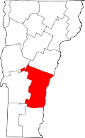 | |
| Villages | ||
| CDPs | ||
| Other communities | ||
This article is issued from Wikipedia - version of the 1/17/2016. The text is available under the Creative Commons Attribution/Share Alike but additional terms may apply for the media files.