Baltimore, Vermont
| Baltimore, Vermont | |
|---|---|
| Town | |
|
Motto: 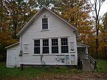 Baltimore, Vermont Town Office | |
 Location in Windsor County and the state of Vermont. | |
 Baltimore, Vermont Location in the United States | |
| Coordinates: 43°21′N 72°34′W / 43.350°N 72.567°WCoordinates: 43°21′N 72°34′W / 43.350°N 72.567°W | |
| Country | United States |
| State | Vermont |
| County | Windsor |
| Area | |
| • Total | 4.7 sq mi (12.1 km2) |
| • Land | 4.7 sq mi (12.1 km2) |
| • Water | 0.0 sq mi (0.0 km2) |
| Elevation | 1,020 ft (311 m) |
| Population (2010) | |
| • Total | 244 |
| • Density | 52/sq mi (20/km2) |
| Time zone | Eastern (EST) (UTC-5) |
| • Summer (DST) | EDT (UTC-4) |
| ZIP code | 05143 |
| Area code(s) | 802 |
| FIPS code | 50-02575[1] |
| GNIS feature ID | 1462032[2] |
Baltimore is a town in Windsor County, Vermont, United States. The population was 244 at the 2010 census.[3]
Its name ultimately comes from Irish: Baile an Tí Mhóir, meaning "town of the big house".
Geography
According to the United States Census Bureau, the town has a total area of 4.7 square miles (12.1 km2), all land. There are 7.2 miles (11.6 km) of gravel roads.
Demographics
| Historical population | |||
|---|---|---|---|
| Census | Pop. | %± | |
| 1800 | 174 | — | |
| 1810 | 207 | 19.0% | |
| 1820 | 204 | −1.4% | |
| 1830 | 179 | −12.3% | |
| 1840 | 155 | −13.4% | |
| 1850 | 124 | −20.0% | |
| 1860 | 116 | −6.5% | |
| 1870 | 83 | −28.4% | |
| 1880 | 71 | −14.5% | |
| 1890 | 64 | −9.9% | |
| 1900 | 55 | −14.1% | |
| 1910 | 54 | −1.8% | |
| 1920 | 62 | 14.8% | |
| 1930 | 69 | 11.3% | |
| 1940 | 85 | 23.2% | |
| 1950 | 89 | 4.7% | |
| 1960 | 90 | 1.1% | |
| 1970 | 170 | 88.9% | |
| 1980 | 181 | 6.5% | |
| 1990 | 190 | 5.0% | |
| 2000 | 250 | 31.6% | |
| 2010 | 244 | −2.4% | |
| Est. 2014 | 255 | [4] | 4.5% |
| U.S. Decennial Census[5] | |||
As of the census[1] of 2000, there were 250 people, 92 households, and 74 families residing in the town. The population density was 53.5 people per square mile (20.7/km2). There were 105 housing units at an average density of 22.5 per square mile (8.7/km2). The racial makeup of the town was 98.00% White, 0.40% African American, 0.40% Native American, 0.40% Asian, and 0.80% from two or more races. Hispanic or Latino of any race were 0.40% of the population.
There were 92 households out of which 34.8% had children under the age of 18 living with them, 68.5% were married couples living together, 7.6% had a female householder with no husband present, and 18.5% were non-families. 7.6% of all households were made up of individuals and 2.2% had someone living alone who was 65 years of age or older. The average household size was 2.72 and the average family size was 2.88.
In the town the population was spread out with 24.8% under the age of 18, 6.4% from 18 to 24, 32.8% from 25 to 44, 25.6% from 45 to 64, and 10.4% who are 65 years of age or older. The median age is 37 years. For every 100 females there were 125.2 males. For every 100 females age 18 and over, there were 111.2 males.
The median income for a household in the town was $44,375, and the median income for a family was $46,964. Males had a median income of $28,750 versus $21,563 for females. The per capita income for the town was $17,260. About 2.4% of families and 7.0% of the population were below the poverty line, including 2.9% of those under the age of eighteen and none of those sixty five or over.
References
- 1 2 "American FactFinder". United States Census Bureau. Archived from the original on September 11, 2013. Retrieved 2008-01-31.
- ↑ "US Board on Geographic Names". United States Geological Survey. 2007-10-25. Retrieved 2008-01-31.
- ↑ "Profile of General Population and Housing Characteristics: 2010 Demographic Profile Data (DP-1): Baltimore town, Windsor County, Vermont". U.S. Census Bureau, American Factfinder. Archived from the original on September 11, 2013. Retrieved July 30, 2012.
- ↑ "Annual Estimates of the Resident Population for Incorporated Places: April 1, 2010 to July 1, 2014". Retrieved June 4, 2015.
- ↑ "U.S. Decennial Census". United States Census Bureau. Archived from the original on May 11, 2015. Retrieved May 16, 2015.
Municipalities and communities of Windsor County, Vermont, United States | ||
|---|---|---|
| Towns | 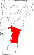 | |
| Villages | ||
| CDPs | ||
| Other communities | ||