Barnard, Vermont
| Barnard, Vermont | |
|---|---|
| Town | |
|
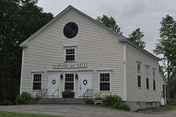
Town hall | |
 Location in Windsor County and the state of Vermont. | |
 Barnard, Vermont Location in the United States | |
| Coordinates: 43°44′9″N 72°36′9″W / 43.73583°N 72.60250°WCoordinates: 43°44′9″N 72°36′9″W / 43.73583°N 72.60250°W | |
| Country | United States |
| State | Vermont |
| County | Windsor |
| Area | |
| • Total | 48.9 sq mi (126.6 km2) |
| • Land | 48.7 sq mi (126.1 km2) |
| • Water | 0.2 sq mi (0.5 km2) |
| Elevation | 1,181 ft (360 m) |
| Population (2010) | |
| • Total | 947 |
| • Density | 19/sq mi (7.5/km2) |
| Time zone | Eastern (EST) (UTC-5) |
| • Summer (DST) | EDT (UTC-4) |
| ZIP code | 05031 |
| Area code(s) | 802 |
| FIPS code | 50-02725[1] |
| GNIS feature ID | 1462033[2] |
Barnard /ˈbɑːrnərd/ is a town in Windsor County, Vermont, United States. The population was 947 at the 2010 census.[3]
History
The town was chartered on July 17, 1761, by a New Hampshire Grant and named "Bernard" after the second-listed grantee of the town (with five others), Sir Francis Bernard, 1st Baronet, and since 1760 Governor of the Province of Massachusetts Bay. The town's name was changed to Barnard some time before 1810.[4]
In 1928, Nobel Prize-winning novelist Sinclair Lewis bought Connett Place with a total 300 acres (1.2 km2) and adjacent Chase Farm. He named the property Twin Farms and used it as a vacation house during the 1930s and 1940s with his wife Dorothy Thompson.[5]
In 1941, German playwright Carl Zuckmayer, a refugee from Nazi Germany whom Dorothy Thompson had helped to get into the US, rented Backwoods Farm, with its farmhouse from 1783 nowadays owned by Hannah Kahn[6] and a total 180 acres (0.73 km2), from Joseph Ward (of Maynes & Ward hardware store on Main Street in Woodstock, Vermont) for 50 dollars a month. Zuckmayer worked this property as a farmer until 1946 and wrote the play Des Teufels General (The Devil's General) there. His autobiography A part of myself (1966) deals extensively with these years. Zuckmayer's wife Alice Herdan-Zuckmayer also wrote a memoir of their time in Barnard: The Farm in the Green Mountains (Die Farm in den grünen Bergen).[7]
Geography
According to the United States Census Bureau, the town has a total area of 48.9 square miles (126.6 km2), of which 48.7 square miles (126.1 km2) are land and 0.2 square mile (0.5 km2) is water.
Demographics
| Historical population | |||
|---|---|---|---|
| Census | Pop. | %± | |
| 1790 | 673 | — | |
| 1800 | 1,236 | 83.7% | |
| 1810 | 1,648 | 33.3% | |
| 1820 | 1,691 | 2.6% | |
| 1830 | 1,881 | 11.2% | |
| 1840 | 1,774 | −5.7% | |
| 1850 | 1,647 | −7.2% | |
| 1860 | 1,487 | −9.7% | |
| 1870 | 1,208 | −18.8% | |
| 1880 | 1,191 | −1.4% | |
| 1890 | 918 | −22.9% | |
| 1900 | 840 | −8.5% | |
| 1910 | 737 | −12.3% | |
| 1920 | 653 | −11.4% | |
| 1930 | 584 | −10.6% | |
| 1940 | 486 | −16.8% | |
| 1950 | 439 | −9.7% | |
| 1960 | 435 | −0.9% | |
| 1970 | 569 | 30.8% | |
| 1980 | 790 | 38.8% | |
| 1990 | 872 | 10.4% | |
| 2000 | 958 | 9.9% | |
| 2010 | 947 | −1.1% | |
| Est. 2014 | 931 | [8] | −1.7% |
| U.S. Decennial Census[9] | |||
As of the census[1] of 2000, there were 958 people, 383 households, and 276 families residing in the town. The population density was 19.7 people per square mile (7.6/km2). There were 629 housing units at an average density of 12.9 per square mile (5.0/km2). The racial makeup of the town was 98.43% White, 0.42% Hispanic or Latino, 0.31% Asian and 1.04% from two or more races.
There were 383 households, out of which 29.2% had children under the age of 18 living with them, 61.4% were married couples living together, 6.8% had a female householder with no husband present, and 27.7% were non-families. 21.1% of all households were made up of individuals and 5.7% had someone living alone who was 65 years of age or older. The average household size was 2.50 and the average family size was 2.84.
In the town the population was spread out with 23.4% under the age of 18, 5.1% from 18 to 24, 26.4% from 25 to 44, 32.0% from 45 to 64, and 13.0% who were 65 years of age or older. The median age was 42 years. For every 100 females there were 93.9 males. For every 100 females age 18 and over, there were 97.8 males.
The median income for a household in the town was $45,787, and the median income for a family was $48,125. Males had a median income of $29,485 versus $25,385 for females. The per capita income for the town was $25,354. About 4.7% of families and 6.3% of the population were below the poverty line, including 10.0% of those under age 18 and 2.4% of those age 65 or over.
Silver Lake State Park
Silver Lake State Park, encompassing the northern shoreline of Silver Lake, was established in 1955 when some land with shore frontage was donated to the state by John McDill of Woodstock, Margaret Crosby of Barnard, and Richard H. Field of Boston. Silver Lake had originally been called Stebbings' Pond after Benjamin Stebbings who owned land at the outlet where the village now stands. Later the lake became known as Barnard Pond. In 1869, it was renamed Silver Lake.[10]
Education
Barnard Academy is a public elementary school located on Route 12. It has educational programs from pre-kindergarten through sixth grade. Barnard Academy is part of the Windsor Central Supervisory Union. In 2008, the school began adopting the Core Knowledge Curriculum and is a friend of the Core Knowledge Schools. The complete adoption of this curriculum will take about three to four years.[11]
Notable people
- Andrew J. Aikens, newspaper editor
- Sinclair Lewis, Nobel Prize-winning novelist, short-story writer, and playwright[5]
- Mark Mitchell, architect and politician[12]
- Dorothy Thompson, journalist
- Carl Zuckmayer, German writer and playwright[7]
References
| Wikimedia Commons has media related to Barnard, Vermont. |
- 1 2 "American FactFinder". United States Census Bureau. Archived from the original on September 11, 2013. Retrieved 2008-01-31.
- ↑ "US Board on Geographic Names". United States Geological Survey. 2007-10-25. Retrieved 2008-01-31.
- ↑ "Profile of General Population and Housing Characteristics: 2010 Demographic Profile Data (DP-1): Barnard town, Windsor County, Vermont". U.S. Census Bureau, American Factfinder. Archived from the original on September 11, 2013. Retrieved July 30, 2012.
- ↑ About Barnard, Vermont, Virtual Vermont website, accessed January 23, 2015.
- 1 2 http://www.vpr.net/episode/33377/
- ↑ http://www.thevermontstandard.com/2010/11/45-year-wait-ends-at-the-zuckmayer-farm/
- 1 2 http://www.vpr.net/news_detail/79860/
- ↑ "Annual Estimates of the Resident Population for Incorporated Places: April 1, 2010 to July 1, 2014". Retrieved June 4, 2015.
- ↑ "U.S. Decennial Census". United States Census Bureau. Archived from the original on May 11, 2015. Retrieved May 16, 2015.
- ↑ "Archived copy". Archived from the original on 2010-04-26. Retrieved 2009-08-14.
- ↑ http://barnardacademy.org/
- ↑ 'Mark Mitchell-obituary,' The Rutland Herald, November 2, 1011
Municipalities and communities of Windsor County, Vermont, United States | ||
|---|---|---|
| Towns | 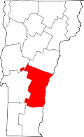 | |
| Villages | ||
| CDPs | ||
| Other communities | ||