Nové Zámky
| Nové Zámky | ||
| Érsekújvár | ||
| Town | ||
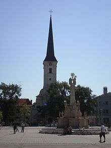
 Main square of Nové Zámky | ||
|
||
| Country | Slovakia | |
|---|---|---|
| Region | Nitra | |
| District | Nové Zámky | |
| River | Nitra | |
| Elevation | 119 m (390 ft) | |
| Coordinates | SK 47°59′08″N 18°09′28″E / 47.98556°N 18.15778°ECoordinates: SK 47°59′08″N 18°09′28″E / 47.98556°N 18.15778°E | |
| Area | 72.565 km2 (28.018 sq mi) | |
| Population | 39,585 (2011-12-31) | |
| Density | 546/km2 (1,414/sq mi) | |
| Founded | 1573 | |
| Mayor | Otokar Klein | |
| Timezone | CET (UTC+1) | |
| - summer (DST) | CEST (UTC+2) | |
| Postal code | 940 01 | |
| Area code | +421-35 | |
| Car plate | NZ | |
  Location in Slovakia | ||
  Location in the Nitra Region | ||
| Wikimedia Commons: Nové Zámky | ||
| Statistics: MOŠ/MIS | ||
| Website: www.novezamky.sk | ||

Nové Zámky (![]() pronunciation ; Hungarian: Érsekújvár, German: Neuhäus[e]l, Turkish: Uyvar, Latin: Novum Castrum) is a town in southwestern Slovakia.
pronunciation ; Hungarian: Érsekújvár, German: Neuhäus[e]l, Turkish: Uyvar, Latin: Novum Castrum) is a town in southwestern Slovakia.
Geography
The town is located on the Danubian Lowland, on the Nitra River, at an altitude of 119 metres. It is located around 100 km from Bratislava and around 25 km from the Hungarian border. It is a road and railway hub of southern Slovakia.
The town lies in the temperate zone and has a continental climate. Annual average temperature reaches around 10 °C (50.0 °F), with the warmest month being July with an average of 20 °C (68 °F) and the coldest January with −2 °C (28 °F). Average annual precipitation is 556 mm.[1]
History


The town has a distinguished history. From the second half of the 10th century until 1918, it was part of the Kingdom of Hungary. A fortress was built, against the Ottoman Turks, on the site of an older settlement in the years 1573–81. Between 1589 and 1663, the settlement was the seat of the Captaincy of Lower Hungary. The town developed around the fortress. The huge new fortress was one of the most modern fortresses in Europe when it was built, a prime example of the star fortress which was considered to be adapted to the advance in artillery in the preceding centuries. (In fact, the Hungarian name means "the archbishop's new castle".)
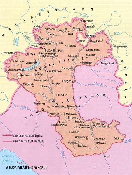
The Turks failed to conquer it six times (except Turkish rule between 1566–1595[2] and 1605–1606),[3] but in 1663 they managed to do so. It was made the center of a Turkish eyalet in present-day southern Slovakia – with the subordinate sanjaks of Litra, Leve, Novigrad, Holok, Bukabak and Şefradi (probably Šahy).
The saying "Strong as a Turk in front of Nové Zámky", which means working with determination and stability, reflects the memory of conquest determination of the Turks.
In 1685 it was conquered by the imperial troops of Charles V, Duke of Lorraine. Six years later, it received town privileges from the Esztergom archbishop.
The town also played an important role in many anti-Habsburg uprisings in the northern parts of Royal Hungary in the 17th century. Emperor Charles VI had it razed in 1724–1725, to prevent potential further insurrections which would use the fortress as their base.
After break-up of Austria-Hungary in 1918/1920, the town became part of newly created Czechoslovakia. As a result of the First Vienna Award, it was occupied by Hungary between 1938 and 1945. Finally, during World War II (1944), the town was heavily damaged by bombings of the Allies.[4] Only small parts of the fortress are still standing today. It is, however, still depicted on the city's coat of arms.
Culture
Synagogue
The orthodox synagogue is located at Česká bašta and dates from the second half of the 19th century. After reconstruction in 1992 it was registered as a historic landmark of Slovakia. It is one of only four synagogues in Slovakia (in Bratislava, Košice, Bardejov and Nové Zámky) that are used for religious purposes by the local Jewish community.
Franciscan church and monastery
The Franciscan church and monastery was built in the early baroque style in the middle of the 17th century. The complex was renovated in the 18th and at the end of the 19th century.
Demographics
The 2001 census recorded a population of 42 262 people, with 69.67% of them being Slovaks, 27.52% Hungarians and others. The most widespread religion was Roman Catholicism (71.72%), followed by a group without denomination (17.75%) and Evangelics (3.36%).
| Year | Population | Year | Population |
|---|---|---|---|
| |
|
|
|
| |
|
|
|
| |
|
|
|
| |
|
|
|
| |
|
|
|
| |
|
|
|
| |
|
|
|
| |
|
|
|
| |
|
|
|
| |
|
|
|
| |
|
|
|
| |
|
|
|
| 1700 | 1720 | 1890 | 1910 | 1930 | 1938 | 1991 | 2001 | |
|---|---|---|---|---|---|---|---|---|
| |
|
|
|
|
|
|
|
|
| |
|
|
|
|
|
|
|
|
| |
|
|
|
|
|
|
|
|
| |
|
|
|
|
|
|
|
|
| |
|
|
|
|
|
|
|
|
Famous people
- Ernest Klein – rabbi, linguist and author
- Lucien Aigner – photographer
- Anton Bernolák – linguist
- Ferenc Helbing – graphic artist
- Lajos Kassák – writer, critic, poet, publisher
- Henrieta Nagyová – tennis player
- Peter Ölvecký – professional ice hockey player
- Ladislav Pataki – sports scientist, athletics coach, masters athletics champion
- György Pray – Jesuit Abbot, canon, librarian, historian
- Miriam Roth – Israeli pioneer of preschool education, author and scholar of children's literature
- Martina Suchá – tennis player
Partner towns
-
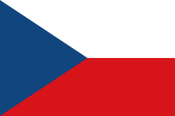 Znojmo, Czech Republic
 -
 Fonyód, Hungary.
References
- ↑ "(Slovak)". Novezamky.sk. Retrieved 2012-01-16.
- ↑ http://mek.niif.hu/01800/01885/html/cd5m/kepek/c4341pe94122.jpg
- ↑ "Kanuni'nin Deniz Siyaseti". Egze.com. 6 March 2006. Retrieved 2012-01-16.
- ↑ http://en.slowakei-netz.de/165/nitra-en/nz-en.html