Ohakune
- "Big Carrot" redirects here. Big Carrot was also a pseudonym used by the band T. Rex.
| Ohakune Ōhākune (Māori) | |
|---|---|
| Minor urban area | |
|
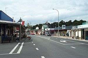
Main street of Ohakune | |
 Ohakune | |
| Coordinates: NZ 39°25′07″S 175°23′58″E / 39.41861°S 175.39944°ECoordinates: NZ 39°25′07″S 175°23′58″E / 39.41861°S 175.39944°E | |
| Country | New Zealand |
| Region | Manawatu-Wanganui Region |
| Territorial authority | Ruapehu District |
| Ward | Waimarino-Waiouru |
| Electorate | Rangitīkei |
| Government | |
| • Mayor | Don Cameron |
| Elevation | 590 m (1,940 ft) |
| Population (June 2016)[1] | |
| • Total | 1,100 |
| Time zone | NZST (UTC+12) |
| • Summer (DST) | NZDT (UTC+13) |
| Postcode | 4625 |
| Telephone | 06 |
Ohakune is a small town in the North Island of New Zealand, situated 215 kilometres north of Wellington and 292 kilometres south of Auckland. It is located at the southern end of the Tongariro National Park, close to the southwestern slopes of the active volcano Mount Ruapehu. Located within the Manawatu-Wanganui region, the town is 70 kilometres northeast of Wanganui and 25 kilometres west of Waiouru.
A rural service town known as New Zealand's Carrot Capital,[2] Ohakune is a popular base in winter for skiers using the ski fields (particularly Turoa) of nearby Mount Ruapehu and in summer for trampers hiking the Tongariro Alpine Crossing.
History
Historically, the lands to the south and west of Mount Ruapehu were inhabited by the Māori of the Ngāti Rangi iwi.[3] Around the middle of the seventeenth century a marae (village) at Rangataua, a small town about 3 miles south-east of Ohakune, was attacked and the inhabitants were driven from their homes by raiders from the Ngāti Raukawa, an iwi from farther east in Manawatu. Around 75 of the village's population were slain and the dozen or so survivors fled to Mangaorongo and established a pā on the present site of the town of Ohakune.
In 1883 the first engineering reconnaissance commenced for the Marton – Te Awamutu section of the North Island Main Trunk Railway and a base was established upon the present site of Ohakune, and soon became a permanent camp for railway and road construction workers. Settlement of the town is considered to have commenced in the early 1890s and by March 1908 the railway line had reached Ohakune. The period of railway construction activities was followed quickly by intensive timber milling; as the forest was cleared, cattle and sheep were introduced and farming progressed. Ohakune was constituted a town district in August 1908 and in November 1911 attained borough status.[4]
The meaning of the name Ohakune is obscure.
In 2015, the town received national publicity after schools were placed in lockdown due to the police being shot at and rammed.[5]
Facilities
Ohakune has facilities for snow sports, trout fishing, mountain biking, tramping and bushwalking.
Landmarks
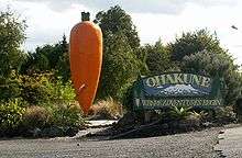
On the eastern edge of the town there is a large replica of a carrot, known locally as "The Big Carrot". This is reputedly the world's largest model carrot, and was originally constructed as a prop for a television advertisement for the ANZ Bank in the early 1980s. After filming the carrot was donated to Ohakune, in recognition of the area's reputation as the source of a high proportion of New Zealand's carrots, and installed in its current position in 1984.[6]
In the 1980s and 90s Ohakune used to be home to the Weather Rock, a local landmark in Thames Street popular with tourists for photographs; the rock used to "forecast" current weather conditions with a sign listing sayings such as "If rock is hot - sunny", "If rock is wet - raining", etc., and appropriately for the region, "If rock is bouncing - earthquake". The site is currently vacant.
Health and Welfare
In 2015 Ohakune had a dental clinic, pharmacy, fire station, police station, ambulance station, social welfare branch, churches, a marae with a district nurse, gymnasium, and a health shuttle for outpatient care at Wanganui Hospital 110 km away.
The nearest medical centre with GP, nurses and physiotherapist is 11 km to the west, at Raetihi.
Shopping and Services
Ohakune has the usual range of shops and services found within a typical small New Zealand town.
Sporting Clubs
Ohakune has a number of clubs and is home to the Ruapehu Rugby & Sports Club
Activities and Events
Winter Activities
Ohakune provides easy access to the nearby ski fields of Mount Ruapehu; the large commercials ski resorts of Turoa (the closest resort to Ohakune) and Whakapapa, and well as the small club field Tukino. Various outlets for clothing and ski hire, as well as purchasing lift tickets, are available in the town.
Ohakune is the home of the Ski FM Network[7] hosted by 91.8 FM Ruapehu/Turoa, a Central North Island radio station that has been in operation for more than 25 years providing local information regarding mountain conditions in both winter and summer. During the winter it is the "information desk" and source of all things snow for the region. During the summer its website (along with the 0800 number) become a hub for summer tourists, and locals alike, for up-to-the-minute information.
Summer Activities
Ohakune caters for various summer activities, and provides access for trampers hiking the Tongariro Alpine Crossing. Mountain bikes are available for hire at various outlets in town.
Various water activities are available on the nearby rivers, with jet boating on the Whanganui River and rafting available along the Whanganui, Rangitikei and Tongariro rivers. Trout fishing is available in nearby lakes and rivers, including the world famous Tongariro River. Activities can be booked at the Ruapehu i-SITE.
The Bridge to Nowhere in the Whanganui National Park located between Okakune and Wanganui is a popular destination for trampers and mountain bikers.
Events
In recent years the number of events hosted by Ohakune has increased, with both the Big Mountain Short Film Festival and Ohakune Mardi Gras[8] featuring on the calendar. The Mardi Gras is both a ski party and celebration of winter, and includes musicians, stalls and rides.
Ohakune is also part of the Fallout Festival,[9] an annual event that focuses on bringing creative elements into the community to celebrate the snow season.
Education
Ohakune has three schools.
- Ohakune School is a state full primary (Year 1–8) school. It has 185 students as of July 2016.[10]
- Ruapehu College is a state secondary (Year 9–13) school. It has 152 students as of July 2016.[10]
- Te Kura Kaupapa Māori o Ngati Rangi is a state Māori-immersion full primary (Year 1–8) school. It has 11 students as of July 2016.[10]
Transportation
State Highway 49 runs through the town, where it is locally named Clyde Street. Ohakune is also on the North Island Main Trunk Railway.
Buses
Ohakune is on the Intercity coach network, with a daily service running north to Auckland via Taumarunui and south to Palmerston North via Wanganui.[11]
Local services to Taupo via the towns of National Park and Turangi are operated by a private shuttle service, the Alpine Hot Bus.[12]
Trains
The North Island Main Trunk Railway provides passenger and freight rail services to Ohakune. The railway station is located off Thames Street in the Ohakune Junction area, approximately 2.5 kilometres from Clyde Street in the centre of town.
Passenger services are provided by the national operator KiwiRail. The Northern Explorer is a non-daily service operating between Auckland and Wellington.[13] The journey to/from Auckland crosses the famous Raurimu Spiral.
From 18 December 1917 until 1 January 1968, Ohakune was also the junction for the Raetihi Branch, a branch line railway to Raetihi. A truss bridge formerly used by this branch still stands near the Big Carrot. Seventeen kilometres to the east of the town is the Tangiwai Bridge, site of New Zealand's worst railway accident, the Tangiwai Disaster, on 24 December 1953.
Trivia
A mock-romantic song from the mid-1960s called September in Ohakune was recorded by Peter Harcourt on an LP called Land of the Long White Shroud
The world's first commercial bungy jumping site was established just outside Ohakune at the old railway viaduct. This was operated during the 1980s until the bridge became too unsafe to continue operations. This bridge is now restored and a highlight of the 'Old Coach Road' walk/bikeway.
Ohakune railway station has the second highest elevation of any operating railway station in New Zealand behind National Park Railway Station; a sign on the platform side of the station building lists its height at 2,029 feet (618.4 metres) above sea level.
See also
References
- ↑ "Subnational Population Estimates: At 30 June 2016 (provisional)". Statistics New Zealand. 21 October 2016. Retrieved 21 October 2016. For urban areas, "Subnational population estimates (UA, AU), by age and sex, at 30 June 1996, 2001, 2006-16 (2017 boundary)". Statistics New Zealand. 21 October 2016. Retrieved 21 October 2016.
- ↑ Ohakune Info
- ↑ Directory of Iwi and Māori Organisations
- ↑ Encyclopedia of New Zealand 1966
- ↑ Shots fired. "North Island shooting". Stuff.
- ↑ "Ohakune's Big Carrot turns twenty next month". Wanganui Chronicle. 21 September 2004. Retrieved 24 March 2012.
- ↑ Ski FM Network
- ↑ Ohakune Mardi Gras
- ↑ Fallout Festival
- 1 2 3 "Directory of Schools - as at 2 August 2016". New Zealand Ministry of Education. Retrieved 2016-08-16.
- ↑ Intercity Ohakune Service Timetable
- ↑ Alpine Hot Bus
- ↑ KiwiRail Scenic Long Distance Train Timetables