Ohio State Route 219
| ||||
|---|---|---|---|---|
 | ||||
| Route information | ||||
| Maintained by ODOT | ||||
| Length: | 37.22 mi[1] (59.90 km) | |||
| Existed: | 1925 – present | |||
| Major junctions | ||||
| West end: | Indiana State Line near Fort Recovery | |||
|
| ||||
| East end: |
| |||
| Location | ||||
| Counties: | Mercer, Auglaize, Shelby | |||
| Highway system | ||||
| ||||

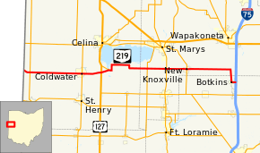
State Route 219 (SR 219) is an east–west state highway in the western portion of the U.S. state of Ohio. State Route 219's western terminus is at the Indiana State Line approximately 5.5 miles (8.9 km) northwest of Fort Recovery, with the roadway continuing west into the Hoosier State being County Road 300N. The eastern terminus of State Route 219 is at a diamond interchange with Interstate 75 at its Exit 104 in Botkins.
Route description
Along its path, State Route 219 traverses portions of Mercer, Auglaize and Shelby Counties. There are no parts of this state highway that are included within the National Highway System, a system of routes deemed most imperative for the nation's economy, mobility and defense.[2]
History
When it was first designated in 1925, State Route 219 was routed between its current western terminus at the Indiana State Line and its junction with State Route 66.[3][4] In 1937, State Route 219 was extended east to a new endpoint at what was U.S. Route 25 (current County Road 25A).[5][6]
Following completion of Interstate 75 through northern Shelby County and southern Auglaize County in 1962, U.S. Route 25 was re-routed onto the new freeway, and State Route 219 was extended. From its former eastern terminus, it was routed south along the former U.S. Route 25 into Botkins, then east along County Road 22 to a new terminus at a diamond interchange with the new freeway.[7][8]
By 1973, State Route 219 experienced a re-routing through eastern Mercer County. The designation was removed from what is now County Road 219A, and applied to what was a former eastern extension of State Route 703 along the south side of Grand Lake Saint Marys between the Burge Road intersection and the Mercer-Auglaize County Line. Jurisdiction of the former southerly routing of State Route 219 was turned over to Mercer County, and the aforementioned designation of County Road 219A was applied to it.[9][10]
Major intersections
| County | Location | mi[1] | km | Destinations | Notes |
|---|---|---|---|---|---|
| Mercer | Washington Township | 0.00 | 0.00 | CR 300N | Indiana state line |
| 1.09 | 1.75 | ||||
| Coldwater | 9.31 | 14.98 | |||
| Butler–Franklin township line | 12.37 | 19.91 | |||
| Montezuma | 13.59 | 21.87 | Western terminus of SR 703 | ||
| Auglaize | Saint Marys Township | 21.05 | 33.88 | ||
| 24.07 | 38.74 | ||||
| New Knoxville | 27.29 | 43.92 | |||
| Shelby | Botkins | 37.22 | 59.90 | Exit 104 (I-75) | |
| 1.000 mi = 1.609 km; 1.000 km = 0.621 mi | |||||
References
- 1 2 Ohio Department of Transportation. "Technical Services Straight Line Diagrams". Retrieved 2010-10-02.
- ↑ National Highway System: Ohio (PDF) (Map). Federal Highway Administration. December 2003. Retrieved 2010-10-02.
- ↑ Ohio State Map (Map). Ohio Department of Transportation. 1924.
- ↑ Ohio State Map (Map). Ohio Department of Transportation. 1925.
- ↑ Ohio State Map (Map). Ohio Department of Transportation. 1936.
- ↑ Ohio State Map (Map). Ohio Department of Transportation. 1937.
- ↑ Ohio State Map (Map). Ohio Department of Transportation. 1961.
- ↑ Ohio State Map (Map). Ohio Department of Transportation. 1962.
- ↑ Ohio State Map (Map). Ohio Department of Transportation. 1971.
- ↑ Ohio State Map (Map). Ohio Department of Transportation. 1973.