Ohio State Route 364
| ||||
|---|---|---|---|---|
 | ||||
| Route information | ||||
| Maintained by ODOT | ||||
| Length: | 16.73 mi[1][2][3] (26.92 km) | |||
| Existed: | 1936 – present | |||
| Major junctions | ||||
| South end: |
| |||
|
| ||||
| North end: |
| |||
| Location | ||||
| Counties: | Darke, Mercer, Auglaize | |||
| Highway system | ||||
| ||||

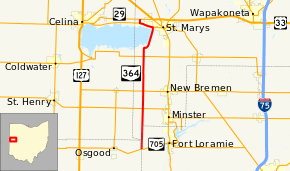
State Route 364 (SR 364) is a north–south state route in Ohio. It starts from SR 705 near Yorkshire. The route moves north across several counties, before moving northeast against the side of the Grand Lake. SR 364 moves back west, and ends at SR 29 near St. Marys. The route was designated in 1936, and was extended twice: in 1938 and 1973.
Route description
| County Log Point | Volume | ||||
|---|---|---|---|---|---|
| 0.6 | 910 | ||||
| 1.0 | 1,190 | ||||
| 5.0 | 1,540 | ||||
| 7.85 | 1,870 | ||||
| 10.0 | 2,440 | ||||
| 12.0 | 2,980 | ||||
| 13.39 | 7,860 | ||||
| 15.2 | 1,720 | ||||
| 15.5 | 380 | ||||
SR 364 travels through portions of Darke, Mercer, and Auglaize Counties. There are no segments of SR 364 that are included within the National Highway System (NHS). The NHS is a network of highways identified as being most important for the economy, mobility and defense of the country.[5]
SR 364 starts at SR 705, on the Darke–Shelby county line.[6] The route goes north in a straight line, through 53 yards (0.030 mi) of Mercer County, and continues onto the Auglaize–Shelby county line.[7] SR 364 continues into Auglaize County, where it passes by the St. Joseph Catholic Church, a historic site. The highway intersects SR 119 in Minister and SR 274 in New Bremen. Later, SR 364 meets SR 219, and moves northeast, next the eastern side of the Grand Lake. Here, the farmland transitions into forests. The route meets at an T-intersection with SR 703. SR 364 and SR 703 move northwest, and SR 364 splits and heads north, after slightly more than a mile. SR 364 crosses a railroad track, and ends at an diamond interchange at SR 29. County Road 15 continues after this point.[8][9]
History
SR 364 was designated in 1936, connecting from SR 219 to SR 703.[10] In 1938, the route was extended south to SR 705 near Osgood,[11] The section between SR 219 and SR 29 (now SR 703) was resurfaced in asphalt in 1939,[12] and all of the route was completely resurfaced by next year.[13] It was extended north to SR 29 in 1973, as SR 29 was rerouted and upgraded to a divided highway.[14]
Major intersections
| County | Location | mi[1][2][3] | km | Destinations | Notes | |||
|---|---|---|---|---|---|---|---|---|
| Darke–Shelby county line | Patterson Township | 0.00 | 0.00 | Southern terminus | ||||
| Mercer |
No major junctions | |||||||
| Shelby–Auglaize county line |
No major junctions | |||||||
| Auglaize | Jackson Township | 4.76 | 7.66 | |||||
| German Township | 6.78 | 10.91 | ||||||
| St. Marys Township | 10.80 | 17.38 | ||||||
| St. Marys | 14.61 | 23.51 | Southern end of concurrency | |||||
| St. Marys Township | 16.19 | 26.06 | Northern end of concurrency | |||||
| Noble Township | 16.73 | 26.92 | Northern terminus; County Road 15 continues after this point | |||||
1.000 mi = 1.609 km; 1.000 km = 0.621 mi
| ||||||||
References
- 1 2 Ohio Department of Transportation. "Technical Services DESTAPE - Darke County" (PDF). Retrieved 2013-11-24.
- 1 2 Ohio Department of Transportation. "Technical Services DESTAPE - Mercer County" (PDF). Retrieved 2013-11-24.
- 1 2 Ohio Department of Transportation. "Technical Services DESTAPE - Auglaize County" (PDF). Retrieved 2013-11-24.
- ↑ Staff. "Transportation Information Mapping System". Ohio Department of Transportation. Retrieved 2013-08-17.
- ↑ National Highway System: Ohio (PDF) (Map). Federal Highway Administration. December 2003. Retrieved 2011-09-24.
- ↑ Ohio Department of Transportation. "Technical Services Straight Line Diagrams – Darke County" (PDF). Retrieved 2013-11-24.
- ↑ Ohio Department of Transportation. "Technical Services Straight Line Diagrams – Mercer County" (PDF). Retrieved 2013-11-24.
- ↑ Ohio Department of Transportation. "Technical Services Straight Line Diagrams – Auglaize County" (PDF). Retrieved 2013-11-24.
- ↑ Google (2013-08-31). "Ohio State Route 364" (Map). Google Maps. Google. Retrieved 2013-08-31.
- ↑ Ohio State Map (Map). Ohio Department of Highways. 1936. Retrieved 2013-08-30.
- ↑ Ohio State Map (Map). Ohio Department of Highways. 1938. Retrieved 2013-08-30.
- ↑ Ohio State Map (Map). Ohio Department of Highways. 1939. Retrieved 2013-12-05.
- ↑ Ohio State Map (Map). Ohio Department of Highways. 1940. Retrieved 2013-12-05.
- ↑ Ohio State Map (Map). Ohio Department of Transportation. 1973. Retrieved 2013-08-30.