Ohio State Route 29
| ||||
|---|---|---|---|---|
 | ||||
| Route information | ||||
| Maintained by ODOT | ||||
| Length: | 102.94 mi[1] (165.67 km) | |||
| Existed: | 1924 – present | |||
| Major junctions | ||||
| West end: |
| |||
|
| ||||
| East end: |
| |||
| Location | ||||
| Counties: | Mercer, Auglaize, Shelby, Champaign, Madison | |||
| Highway system | ||||
| ||||

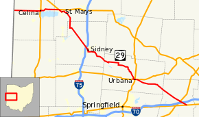
State Route 29 (SR 29) is an east–west state highway in the west-central portion of the U.S. state of Ohio. Its western terminus is at the Indiana state line near Celina, where State Road 67 continues west. It continues east to St. Marys where it junctions with U.S. Route 33. In that town, it also crosses State Route 66, State Route 116, and State Route 703, which was its former alignment before a divided highway was built. After turning south it crosses State Route 219 in New Knoxville and then has an interchange with Interstate 75, continuing into Sidney where it meets State Route 47. Still going southeast, it briefly joins State Route 235 before turning east and then south again to enter Urbana. Here the route joins U.S. Route 36, and the concurrency intersects with U.S. Route 68 and State Route 54. From there, State Route 29 leaves U.S. Route 36 and continues to Mutual, intersecting with State Route 161, and State Route 56 shortly after; later, in Mechanicsburg, the route intersects with State Route 4. The route then intersects with State Route 38, U.S. Route 42, and Interstate 70 before reaching its eastern terminus at U.S. Route 40 on the western edge of West Jefferson.
History
- 1924 – Original route established.[2] Originally routed along the current alignments of State Route 571 from the Indiana state line in Union City to 1-mile (1.6 km) east of Greenville, U.S. Route 36 from 1-mile (1.6 km) east of Greenville to Urbana, and its current alignment from Urbana to 2 miles (3.2 km) west of West Jefferson.[3]
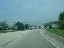 WB OH 29 approaching the eastern junction of SR 29 and SR 703 in Celina.
 - 1932 – The route was truncated at Urbana; alignment from Union City to Greenville designated as State Route 71; Greenville to Urbana designated as U.S. Route 36.[3]
- 1939 – The route was extended to the Indiana state line along the former State Route 54 alignment (which was State Route 32 before 1938).[3]
- 1973 – Divided highway alignment constructed from Celina to State Route 364 and freeway alignment constructed from State Route 364 to U.S. Route 33; former alignment designated State Route 703.[3]
Major junctions
| County | Location | mi[1] | km | Destinations | Notes |
|---|---|---|---|---|---|
| Mercer | Washington Township | 0.00 | 0.00 | Indiana state line | |
| 0.96 | 1.54 | ||||
| Jefferson Township | 8.17 | 13.15 | Western end of SR 118 concurrency | ||
| 9.17 | 14.76 | Eastern end of SR 118 concurrency | |||
| Celina | 12.21 | 19.65 | Western end of US 127 / SR 703 concurrencies | ||
| 12.44 | 20.02 | Eastern end of US 127 concurrency; western terminus of SR 197 | |||
| 13.46 | 21.66 | Eastern end of SR 703 concurrency | |||
| Auglaize | Noble Township | 19.22– 19.55 | 30.93– 31.46 | Interchange; northern terminus of SR 364 | |
| 20.54– 21.11 | 33.06– 33.97 | Interchange | |||
| St. Marys | 22.17 | 35.68 | Western end of SR 116 concurrency | ||
| 22.67 | 36.48 | Eastern end of SR 116 concurrency; western end of SR 66 concurrency; eastern terminus of SR 703 | |||
| 23.03 | 37.06 | Eastern end of SR 66 concurrency | |||
| New Knoxville | 28.77 | 46.30 | |||
| Shelby | Van Buren Township | 32.73 | 52.67 | Western end of SR 274 concurrency | |
| 33.58 | 54.04 | Eastern end of SR 274 concurrency | |||
| 37.40 | 60.19 | ||||
| Franklin Township | 41.70 | 67.11 | Eastern terminus of SR 705 | ||
| Clinton Township | 44.36– 44.52 | 71.39– 71.65 | Exit 93 (I-75) | ||
| Sidney | 46.66 | 75.09 | Western end of SR 47 westbound concurrency | ||
| 46.83 | 75.37 | Eastern end of SR 47 westbound concurrency; western end of SR 47 eastbound concurrency | |||
| 46.91 | 75.49 | Eastern end of SR 47 eastbound concurrency | |||
| Perry Township | 49.74 | 80.05 | Western terminus of SR 706 | ||
| Green Township | 53.41 | 85.96 | Northern terminus of SR 589 | ||
| Champaign | Adams Township | 58.34 | 93.89 | Western end of SR 235 concurrency | |
| 58.66 | 94.40 | Eastern end of SR 235 concurrency | |||
| 60.69 | 97.67 | Western terminus of SR 245 | |||
| Concord Township | 66.06 | 106.31 | Northern terminus of SR 560 | ||
| Salem Township | 71.74 | 115.45 | Western terminus of SR 296 | ||
| Urbana | 75.21 | 121.04 | Western end of US 36 concurrency | ||
| 75.88 | 122.12 | Traffic circle | |||
| 76.68 | 123.40 | Northern terminus of SR 54 | |||
| 77.05 | 124.00 | Eastern end of US 36 concurrency | |||
| Mutual | 82.44 | 132.67 | Western terminus of SR 161 | ||
| Union Township | 83.13 | 133.78 | Western terminus of SR 56 | ||
| Mechanicsburg | 86.60 | 139.37 | Western end of SR 559 concurrency | ||
| 86.87 | 139.80 | Eastern end of SR 559 concurrency | |||
| Goshen Township | 88.35 | 142.19 | Northern terminus of SR 187 | ||
| Madison | Monroe–Deer Creek township line | 59.91 | 96.42 | ||
| Jefferson Township | 99.52 | 160.16 | |||
| 100.46– 100.73 | 161.67– 162.11 | Exit 80 (I-70); westbound I-70 ramps intersect SR 29 at roundabout | |||
| West Jefferson | 102.94 | 165.67 | |||
1.000 mi = 1.609 km; 1.000 km = 0.621 mi
| |||||
References
- 1 2 "DESTAPE". Ohio Department of Transportation. July 3, 2014. Retrieved October 3, 2014.
- ↑ Explanation of the Ohio State Highway System (The Unofficial Ohio State Highways Web Site) by John Simpson Archived May 23, 2006, at the Wayback Machine.
- 1 2 3 4 Route 29 (The Unofficial Ohio State Highways Web Site) by John Simpson Archived December 16, 2004, at the Wayback Machine.