Ohio State Route 61
| ||||
|---|---|---|---|---|
|
Route of SR 61 highlighted in red | ||||
| Route information | ||||
| Maintained by ODOT | ||||
| Length: | 91.16 mi[1] (146.71 km) | |||
| Existed: | 1924 – present | |||
| Major junctions | ||||
| South end: |
| |||
|
| ||||
| North end: |
| |||
| Location | ||||
| Counties: | Delaware, Morrow, Crawford, Richland, Huron, Erie | |||
| Highway system | ||||
| ||||

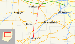
State Route 61 (SR 61) is a north–south state highway in the northern portion of the U.S. state of Ohio. Its southern terminus is at the U.S. Route 36/State Route 3 concurrency in Sunbury, and its northern terminus is at U.S. Route 6 east of Huron, at the southernmost point of Lake Erie (which is subsequently the southernmost northern border of the United States). State Route 61 is routed through the communities of Mount Gilead, Galion, Crestline, Shelby, Plymouth, Norwalk, and Berlin Heights.
Major junctions
| County | Location | mi[1] | km | Destinations | Notes |
|---|---|---|---|---|---|
| Delaware | Sunbury | 0.00 | 0.00 | Southern end of US 36 / SR 3 concurrency | |
| Berkshire Township | 0.43 | 0.69 | Northern end of US 36 / SR 3 concurrency | ||
| Kingston Township | 4.77 | 7.68 | Southern terminus of SR 656 | ||
| 5.45 | 8.77 | ||||
| Morrow | Bennington Township | 9.18– 9.36 | 14.77– 15.06 | Exit 140 (I-71) | |
| 11.11 | 17.88 | ||||
| Lincoln Township | 16.68 | 26.84 | Eastern terminus of SR 529 | ||
| Gilead Township | 21.01 | 33.81 | Southern end of US 42 concurrency | ||
| Mount Gilead | 21.61 | 34.78 | SR 95A (Marion Street) | ||
| 21.74 | 34.99 | ||||
| 21.97 | 35.36 | Northern end of US 42 concurrency | |||
| Washington Township | 30.70 | 49.41 | |||
| 31.01 | 49.91 | Southern end of SR 309 concurrency | |||
| Crawford | Galion | 34.71 | 55.86 | Southern end of SR 19 concurrency; southern terminus of SR 598 | |
| 35.98 | 57.90 | Northern end of SR 19 concurrency | |||
| 38.08 | 61.28 | Northern end of SR 309 concurrency | |||
| Galion–Crestline municipal line | 39.20– 39.34 | 63.09– 63.31 | Interchange | ||
| Crestline | 41.32 | 66.50 | Western terminus of SR 181 | ||
| Richland | Sharon Township | 49.01 | 78.87 | Northern terminus of SR 314 | |
| Shelby | 51.17 | 82.35 | |||
| Plymouth | 58.72 | 94.50 | Southern end of SR 98 concurrency | ||
| Richland–Huron county line | 59.25 | 95.35 | Northern end of SR 98 concurrency; northern terminus of SR 603 | ||
| Huron | New Haven Township | 61.77 | 99.41 | Southern end of SR 598 concurrency | |
| 61.90 | 99.62 | ||||
| 62.16 | 100.04 | Northern end of SR 598 concurrency | |||
| 63.74 | 102.58 | Eastern terminus of SR 103 | |||
| Greenfield Township | 67.39 | 108.45 | |||
| Norwalk | 76.70 | 123.44 | Eastern terminus of unsigned SR 61C | ||
| 78.04 | 125.59 | ||||
| Norwalk Township | 81.21 | 130.69 | |||
| Erie | Berlin Township | 84.91 | 136.65 | Southern end of SR 113 concurrency | |
| Berlin Heights–Berlin Township municipal line | 86.09 | 138.55 | Northern end of SR 113 concurrency | ||
| Berlin Township | 90.38– 90.51 | 145.45– 145.66 | Interchange | ||
| 91.16 | 146.71 | ||||
1.000 mi = 1.609 km; 1.000 km = 0.621 mi
| |||||
SR 61C
State Route 61C (SR 61C) is a 0.72-mile-long (1.16 km)[1] connection between the Norwalk Bypass US 20/SR 18 and SR 61 southwest of Norwalk. The intersection forms a sideways triangle with SR 61 as the base on the east, US 20 as the south side, and Route 61C as the north side. SR 61C exists because US 20 bridges SR 61 on the south side of the triangle and would have not intersected SR 61 otherwise. SR 61C is part of a former alignment of US 20.