Ohio State Route 113
| ||||
|---|---|---|---|---|
 | ||||
| Route information | ||||
| Maintained by ODOT | ||||
| Length: | 59.64 mi[1] (95.98 km) | |||
| Existed: | 1924 – present | |||
| Major junctions | ||||
| West end: |
| |||
| East end: |
| |||
| Location | ||||
| Counties: | Huron, Erie, Lorain, Cuyahoga | |||
| Highway system | ||||
| ||||

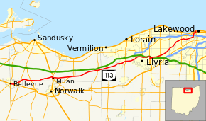
State Route 113 (SR 113) is an east–west highway in north central and northeastern Ohio. Its western terminus is at SR 269 in Bellevue, where SR 113 is initially concurrent with US 20 and SR 18; its eastern terminus is at the US 6 / SR 2 concurrency in Lakewood. Most of its eastern portion is also in a concurrency with US 20.[2]
History
SR 113 is an original state highway that originally went from SR 9 (now US 127) at the small town of Latty to SR 15 near Continental. The route's western terminus was extended to the Indiana state line in 1926, and its eastern terminus was extended to SR 109 north of Ottawa the same year.
By 1935, the route had extended to SR 18 near Bloomdale. Three years later it was extended again, this time all the way to Bellevue, by overlapping SR 18 and SR 12, then following the Sandusky County/Seneca County line to Bellevue. SR 113 was extended twice more – to Elyria in 1939, and to its current eastern terminus in 1940.
In 1959, when the bypass around Fremont opened, SR 113 was rerouted along it, following SR 12 from Bettsville to SR 53, then following that route on the bypass and overlapping US 20 from Fremont to Bellevue, where it continued on its old route to Lakewood. Except for a small stretch of road in downtown Fostoria, SR 113 was now completely concurrent from Bloomdale to Bellevue. Thus in 1970, the route was split into two separate highways. The concurrencies were removed, SR 113 was truncated at Bellevue, and the western part of the route (from the Indiana state line to Fostoria) was recertified as SR 613.
Major junctions
| County | Location | mi[1] | km | Destinations | Notes |
|---|---|---|---|---|---|
| Huron | Bellevue | 0.00 | 0.00 | Western end of US 20 / SR 18 concurrency | |
| 0.09 | 0.14 | ||||
| 0.97 | 1.56 | Eastern end of US 20 / SR 18 concurrency | |||
| Lyme Township | 3.07 | 4.94 | |||
| Erie–Huron county line | Oxford–Ridgefield township line | 6.34 | 10.20 | ||
| Erie | Milan Township | 12.79 | 20.58 | Western end of US 250 / SR 13 concurrency | |
| Milan | 13.37 | 21.52 | Eastern end of US 250 / SR 13 concurrency | ||
| 13.59 | 21.87 | Northern terminus of SR 601 | |||
| Berlin Township | 18.35 | 29.53 | Western end of SR 61 concurrency | ||
| Berlin Heights–Berlin Township municipal line | 19.52 | 31.41 | Western end of SR 61 concurrency | ||
| Florence Township | 26.72 | 43.00 | |||
| Lorain | Amherst Township | 35.10 | 56.49 | ||
| Elyria | 40.36 | 64.95 | Western end of SR 57 concurrency | ||
| 42.43 | 68.28 | Western end of SR 301 concurrency | |||
| 43.05 | 69.28 | Eastern end of SR 57 / 301 concurrency; western end of US 20 concurrency | |||
| North Ridgeville | 46.19 | 74.34 | Access to Ohio Turnpike and I-480 via SR 83 to Lorain road | ||
| Cuyahoga | Westlake | 53.94 | 86.81 | ||
| Rocky River | 58.59 | 94.29 | Western end of US 6 Alt. concurrency; signed eastern terminus | ||
| Lakewood | 58.75 | 94.55 | Eastern end of US 6 Alt. concurrency | ||
| 59.30 | 95.43 | Western end of SR 237 concurrency | |||
| 59.64 | 95.98 | Eastern end of US 20 / SR 237 concurrency; designated eastern terminus of SR 113 | |||
1.000 mi = 1.609 km; 1.000 km = 0.621 mi
| |||||
References
- 1 2 Ohio Department of Transportation. "Technical Services Straight Line Diagrams". Retrieved April 30, 2010.
- ↑ Google (February 12, 2014). "Ohio State Route 113" (Map). Google Maps. Google. Retrieved February 12, 2014.