U.S. Route 6 in Ohio
| ||||
|---|---|---|---|---|
| Grand Army of the Republic Highway[1] | ||||
|
Route of US 6 in Ohio highlighted in red | ||||
| Route information | ||||
| Maintained by ODOT | ||||
| Length: | 248.002 mi[2] (399.121 km) | |||
| Existed: | 1931 – present | |||
| Major junctions | ||||
| West end: |
| |||
| East end: |
| |||
| Location | ||||
| Counties: | Williams, Henry, Wood, Sandusky, Erie, Lorain, Cuyahoga, Lake, Geauga, Ashtabula | |||
| Highway system | ||||
| ||||

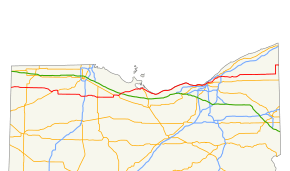
U.S. Route 6 (US 6) is a part of the United States Numbered Highway System that runs from Bishop, California to Provincetown, Massachusetts. US 6 is the second longest federal highway in the United States, second only to U.S. Route 20.[1] In Ohio, the road runs west-east from the Indiana state line near Edgerton to the Pennsylvania state line near Andover. The 248.002 miles (399.121 km) that lie in Ohio are maintained by the Ohio Department of Transportation (ODOT). US 6 serves the major cities of Sandusky, Lorain, and Cleveland. The highway is also called the Grand Army of the Republic Highway to honor the Union forces of the American Civil War.[1] The alternate name was designated in 1953.
US 6 originally ran from Massachusetts to Pennsylvania. It was extended through Ohio to Colorado in June 1931. The route of US 6 has remained largely unchanged since 1931.[1]
Route description
US 6 traverses the far northern portion of Ohio, passing through 10 counties. The highway travels through largely farm and field country until it reaches Sandusky. After Sandusky, US 6 travels along the coast of Lake Erie until Cleveland. From Cleveland to the Pennsylvania state line, Route 6 passes through mostly wooded land.
Western Ohio
US 6 crosses into Williams County, Ohio, at the Indiana state line between Butler, Indiana, and Edgerton, Ohio. The highway goes east from the border, passing through the small town of Edgerton, where it has a brief concurrency with Ohio State Route 49. Continuing east through farm country, US 6 passes through Ridgeville Corners, until reaching Napoleon in Henry County, where it intersects US 24, starting a 4.6-mile long concurrency.[3] East of Napoleon, US 6 passes through McClure. 15 miles east of McClure, Route 6 passes south of the college town of Bowling Green, intersecting with Interstate 75. Along this 15-mile stretch, the road crosses into Wood County. Just east of Bowling Green, US 6 has a 1-mile long overlap with Ohio State Route 199.
US 6 continues through rural country until it passes just north of Bradner. Here, the highway intersects U.S. Route 23 at the Wood-Sandusky county line. In Sandusky County, US 6 passes through the small towns of Rollersville and Helena before reaching the city of Fremont. In Fremont, US 6 overlaps with Ohio State Route 53 for 4.1 miles, US 20 for 3.9 miles, and Ohio State Route 19 for 2.6 miles.[4] Route 6 skirts the northern city limits of Fremont before turning northeast just east of Fremont. 3 miles from Fremont, US 6 crosses under I-80/I-90, but there is not an interchange between the highways. 11 miles northeast of the interstate, US 6 crosses into Erie County.

Just into Erie County, US 6 overlaps Ohio State Route 269 for 0.6 miles, then intersects Ohio State Route 2 1.8 miles east of the SR 269 concurrency.[4] Just east of this intersection, US 6 enters the city of Sandusky. US 6 passes through a largely residential part of Sandusky. Locally, the highway is also known as Tiffin Avenue, West Washington Street, Warren Street, and Cleveland Road West. Cedar Point is accessed from US 6.[5] Southeast of Sandusky, US 6 passes the Griffing Sandusky Airport near Fairview Lanes. As US 6 continues east through Erie County, it passes through the city of Huron, the communities of Mitiwanga and Beulah Beach, and the city of Vermilion before crossing into Lorain County. East of Vermillion, in Lorain County, US 6 enters the city of Lorain, the last major city before the highway reaches Cleveland. In Lorain, Route 6 stays close to the Lake Erie shoreline and crosses the Black River on the Charles Berry Bridge, the second-largest bascule bridge in the world.[6] East of Lorain, US 6 passes through Sheffield Lake and Avon Lake before crossing into Cuyahoga County.
Cleveland
After passing through Bay Village, US 6 enters the suburbs of Cleveland. In Rocky River, US 6 starts concurrencies with Ohio State Route 2 and U.S. Route 20. Also, an alternate route of US 6 starts in Rocky River and winds along Detroit Avenue for 7.3 miles to its eastern terminus just west of the Cuyahoga River in the Ohio City neighborhood.[7]
US 6 enters the city of Cleveland during its overlap with SR 2 and US 20. US 6, along with US 20, splits from SR 2 just before it crosses the Cuyahoga River on the Main Avenue Bridge. Route 6 meets up with Ohio State Route 3 and U.S. Route 42 at West 25th Street, and the four highways (US 6, US 20, US 42, SR 3) cross the Cuyahoga River on the Veterans Memorial Bridge. At the east end of the bridge, US 6 passes through Public Square. Here, the concurrencies with US 20, US 42, and SR 3 end. U.S. Route 322 also starts a concurrency with US 6 in Public Square that ends 0.5 mi east of the plaza
East of Public Square, US 6 has an interchange with Interstate 90. 4.5 miles east of this intersection, US 6 starts another concurrency with US 20 in East Cleveland that lasts for 4.2 miles.[7] After splitting from US 20, US 6 runs concurrent with Ohio State Route 84 for 2.1 miles before entering Lake County.
Eastern Ohio
The 10.23 miles that lie within Lake County pass through many small residential developments in Willoughby Hills and Kirtland before crossing into Geauga County. In Geauga County, US 6 passes through the city of Chardon, where it has a brief overlap with Ohio State Route 44. In Chardon, US 6 turns northeast to serve Hambden Township and Montville Township before crossing into Ashtabula County.
In Ashtabula County, US 6 travels straight east through the townships of Hartsgrove, Rome, New Lyme, and Cherry Valley, as well as the village of Andover before turning north with Ohio State Route 7. 7.5 miles north of Andover, US 6 breaks its concurrency with SR 7, turns east, and enters Pennsylvania in Crawford County, just north of the Pymatuning Reservoir.

History
US 6 was one of the original routes created when the United States Numbered Highway System was formed. Originally, US 6 was only routed from Provincetown, Massachusetts to Brewster, New York.[8] Soon after, it was routed to Pennsylvania and was alternatively named the Roosevelt Highway. The route was not extended into Ohio until 1931, when the highway was expanded to Greeley, Colorado. The Ohio routing established in 1931 has not been changed since then.[1]
By the 1930s, the Roosevelt Highway name had started to fade. Major William Anderson, Jr. took notice of this and proposed the idea of redesignating the highway to honor Union forces during the Civil War. Veteran associations started promoting the idea in 1934. Because each state along the highway owned its portion of US 6, each state had to act on the proposal. Each state had approved the renaming by 1953, and it was in that year that US 6 was designated as the Grand Army of the Republic Highway along its entire length. The name is signed in all 14 states that US 6 passes through.[1][9]
Major intersections
| County | Location | mi[10] | km | Exit | Destinations | Notes |
|---|---|---|---|---|---|---|
| Williams | St. Joseph Township | 0.000 | 0.000 | US 6 continues into Indiana | ||
| Edgerton | 2.975 | 4.788 | Western end of SR 49 concurrency | |||
| 3.031 | 4.878 | Eastern end of SR 49 concurrency | ||||
| Center Township | 10.206 | 16.425 | ||||
| 10.976 | 17.664 | Western end of SR 2 concurrency | ||||
| Pulaski Township | 13.41 | 21.58 | Eastern end of SR 2 concurrency | |||
| Springfield Township | 20.888 | 33.616 | Southern terminus of SR 191 | |||
| 23.252 | 37.420 | Western end of SR 66 concurrency | ||||
| Henry | Ridgeville Township | 26.133 | 42.057 | Eastern end of SR 66 concurrency | ||
| 27.903 | 44.906 | Eastern terminus of SR 34 | ||||
| Napoleon Township | 34.893– 35.883 | 56.155– 57.748 | 39 | Partial cloverleaf interchange; western end of US 24 concurrency; western end of limited-access highway | ||
| Napoleon | 36.663– 36.903 | 59.003– 59.390 | 40 | |||
| 37.943– 38.463 | 61.063– 61.900 | 41 | CR 503 (Industrial Drive) | Diamond interchange; | ||
| Liberty Township | 40.203– 40.433 | 64.700– 65.071 | 43 | No access from US 24 westbound to US 6 eastbound, or US 6 westbound to US 24 eastbound; eastern end of US 24 concurrency, | ||
| 40.343– 40.563 | 64.926– 65.280 | 44A | CR 424 | No access to US 6 westbound from CR 424; former SR 424 | ||
| Harrison Township | 41.013– 41.273 | 66.004– 66.422 | 44B | Exit 44B; eastern end of limited-access highway | ||
| 44.173 | 71.090 | |||||
| McClure | 49.213 | 79.201 | ||||
| Wood | Weston Township | 57.285 | 92.191 | |||
| Bowling Green | 64.678– 65.248 | 104.089– 105.006 | Diamond interchange | |||
| Center Township | 66.019– 66.698 | 106.247– 107.340 | Diamond interchange | |||
| Freedom Township | 72.268 | 116.304 | Western end of SR 199 concurrency | |||
| 73.239 | 117.867 | Eastern end of SR 199 concurrency | ||||
| 76.684 | 123.411 | Eastern terminus of SR 281 | ||||
| Wood–Sandusky county line | Freedom–Scott township line | 77.686 | 125.023 | |||
| Sandusky | Madison Township | 82.706 | 133.102 | Southern terminus of SR 300 | ||
| Washington Township | 85.206 | 137.126 | Northern terminus of SR 635 | |||
| Jackson Township | 81.716 | 131.509 | ||||
| Ballville Township | 90.676 | 145.929 | Western end of SR 53 concurrency | |||
| Sandusky Township | 92.296– 92.746 | 148.536– 149.260 | 98 | Western end of US 20 concurrency; western end of limited-access highway | ||
| Fremont | 93.666– 94.006 | 150.741– 151.288 | 100 | Western end of SR 19 concurrency | ||
| 94.506– 94.996 | 152.093– 152.881 | 101 | Eastern end of SR 53 concurrency | |||
| 96.136– 96.636 | 154.716– 155.521 | 102 | Eastern end of US 20/SR 19 concurrences; eastern end of limited-access highway | |||
| Riley Township | 103.326 | 166.287 | Northern terminus of SR 510 | |||
| Erie | Margaretta Township | 111.508 | 179.455 | Western end of SR 269 concurrency | ||
| 112.14 | 180.47 | Eastern end of SR 269 concurrency | ||||
| Sandusky | 113.756– 114.038 | 183.073– 183.526 | ||||
| 116.452 | 187.411 | Eastern terminus of SR 101 | ||||
| 118.102 | 190.067 | Northern terminus of SR 4 | ||||
| 119.092 | 191.660 | Northern terminus of US 250 | ||||
| 120.041 | 193.187 | Cedar Point Causeway | Access to Cedar Point | |||
| Huron | 125.485– 125.666 | 201.949– 202.240 | Western end of SR 2 concurrency; western end of limited-access highway | |||
| 126.036– 126.597 | 202.835– 203.738 | Eastern end of SR 2 concurrency; no access from SR 2 westbound to US 6 eastbound, or US 6 westbound to SR 2 eastbound; eastern end of limited-access highway | ||||
| 127.638 | 205.413 | Northern terminus of SR 13 | ||||
| Berlin Township | 131.237 | 211.205 | Northern terminus of SR 61 | |||
| Vermilion | 138.652 | 223.139 | Northern terminus of SR 60 | |||
| Lorain | Lorain | 146.022 | 235.000 | SR 611D | Directional alternate of SR 611 | |
| 146.322 | 235.482 | Western terminus of SR 611 | ||||
| 147.752 | 237.784 | Northern terminus of SR 58 | ||||
| 149.192 | 240.101 | Northern terminus of SR 57 | ||||
| Sheffield Lake | 154.952 | 249.371 | Northern terminus of SR 301 | |||
| Avon Lake | 158.092 | 254.424 | Northern terminus of SR 83 | |||
| Cuyahoga | Bay Village | 164.642 | 264.966 | Northern terminus of SR 252 | ||
| Rocky River | 167.942 | 270.276 | — | Western terminus of US 6 Alt; eastbound exit; westbound entrance | ||
| 168.122 | 270.566 | — | Western end of SR 2/SR 254 concurrences; westbound exit; eastbound entrance | |||
| Lakewood | 168.962 | 271.918 | Eastern terminus of SR 254; Northern terminus of SR 237/SR 113; Western end of US 20 concurrency | |||
| Cleveland | 173.112– 173.972 | 278.597– 279.981 | CR 740 | Directional T interchange; western end of limited-access highway | ||
| 174.552– 174.692 | 280.914– 281.140 | CR 747 / CR 748 | ||||
| 175.012– 175.242 | 281.655– 282.025 | Eastern end of SR 2 concurrency; no access from US 6 westbound to SR 2 eastbound; must use West 28th Street; eastern end of limited-access highway | ||||
| 175.282 | 282.089 | Eastern terminus of US 6 Alt; western terminus of US 42 / SR 3 concurrency | ||||
| Eastern terminus of US 20 / US 42 concurrency; western terminus of US 322 concurrency; eastern terminus of US 42; western terminus of US 322 / US 422 / SR 14 / SR 87; northern terminus of SR 3 / SR 8 / SR 43 | ||||||
| 176.752 | 284.455 | Eastern end of US 322 concurrency | ||||
| 177.482– 177.562 | 285.630– 285.758 | |||||
| 178.712 | 287.609 | Southern terminus of SR 283 | ||||
| East Cleveland | 181.972 | 292.856 | Western end of US 20 concurrency | |||
| Euclid | 186.192 | 299.647 | Eastern end of US 20 concurrency and terminus of SR 84 | |||
| Richmond Heights | 188.402 | 303.204 | ||||
| Lake | Willoughby Hills | 189.472 | 304.926 | Eastern end of SR 84 concurrency | ||
| 191.642 | 308.418 | |||||
| 192.802 | 310.285 | |||||
| Kirtland | 196.442 | 316.143 | ||||
| Geauga | Chardon | 204.312 | 328.808 | US 6D | Directional alternate of US 6 | |
| 204.332 | 328.840 | Western end of SR 44 concurrency | ||||
| 204.532 | 329.162 | Eastern end of SR 44 concurrency | ||||
| Hambden Township | 207.882 | 334.554 | ||||
| 208.132 | 334.956 | Western terminus of SR 166 | ||||
| Montville Township | 212.522 | 342.021 | ||||
| 212.942 | 342.697 | |||||
| Ashtabula | Hartsgrove Township | 217.952 | 350.760 | US 6F | Directional alternate of US 6 | |
| 217.992 | 350.824 | Western end of SR 534 concurrency | ||||
| 218.032 | 350.888 | Eastern end of SR 534 concurrency | ||||
| Rome Township | 222.572 | 358.195 | ||||
| New Lyme Township | 226.962 | 365.260 | ||||
| 230.322– 230.532 | 370.667– 371.005 | |||||
| Cherry Valley Township | 232.872 | 374.771 | ||||
| Andover | 237.772 | 382.657 | US 6D | Directional alternate of US 6 | ||
| 237.842 | 382.770 | Western end of SR 7 concurrency | ||||
| 237.902 | 382.866 | Western terminus of SR 85 | ||||
| 237.962 | 382.963 | US 6D | ||||
| Pierpont Township | 245.352 | 394.856 | Eastern end of SR 7 concurrency | |||
| 248.002 | 399.121 | US 6 continues into Pennsylvania | ||||
1.000 mi = 1.609 km; 1.000 km = 0.621 mi
| ||||||
See also
 Ohio portal
 U.S. Roads portal
References
- 1 2 3 4 5 6 Weingroff, Richard (April 7, 2011). "U.S. 6: The Grand Army of the Republic Highway". Federal Highway Administration. Retrieved April 2, 2012.
- ↑ Ohio Department of Transportation Division of Planning Office of Technical Services. "State System Basic Road Inventory". Columbus: Ohio Department of Transportation. Archived from the original on April 27, 2012. Retrieved April 2, 2012.
- ↑ Ohio Department of Transportation Division of Planning Office of Technical Services (July 27, 2011). "Roadway Description Inventory Report: Henry County" (PDF). Columbus: Ohio Department of Transportation. Retrieved April 3, 2012.
- 1 2 Google. "Overview Map of U.S. Route 6 Distances Between Intersections" (Map). Google Maps. Google.
- ↑ Ohio Department of Transportation Division of Planning Office of Technical Services (July 27, 2011). "Roadway Description Inventory Report: Erie County" (PDF). Columbus: Ohio Department of Transportation. Retrieved April 3, 2012.
- ↑ Payerchin, Richard (January 26, 2012). "Charles Berry Bascule Bridge Repair Work to Begin Next Month". The Morning Journal. Lorain, OH. Retrieved April 4, 2012.
- 1 2 Ohio Department of Transportation Division of Planning Office of Technical Services (July 27, 2011). "Roadway Description Inventory Report: Cuyahoga County" (PDF). Columbus: Ohio Department of Transportation. Retrieved April 3, 2012.
- ↑ U.S. Route 6 Tourist Association. "U.S. Route 6 History". U.S. Route 6 Tourist Association. Retrieved April 3, 2012.
- ↑ Heritage Documentaries. "Our Story of Route 6". Heritage Documentaries. Retrieved April 3, 2012.
- ↑ Ohio Department of Transportation Division of Planning Office of Technical Services. "Technical Services DESTAPE (By County)". Columbus: Ohio Department of Transportation. Retrieved April 3, 2012.
External links
 Media related to U.S. Route 6 in Ohio at Wikimedia Commons
| Previous state: Indiana |
Ohio | Next state: Pennsylvania |