Ohio State Route 613
| ||||
|---|---|---|---|---|
 | ||||
| Route information | ||||
| Maintained by ODOT | ||||
| Length: | 75.95 mi[1] (122.23 km) | |||
| Existed: | 1970 – present | |||
| Major junctions | ||||
| West end: | State Line Road (C-1) near Payne | |||
|
| ||||
| East end: |
| |||
| Location | ||||
| Counties: | Paulding, Putnam, Hancock, Seneca | |||
| Highway system | ||||
| ||||

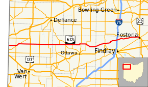
State Route 613 (SR 613) is an east–west state highway in the northwestern portion of the U.S. state of Ohio. Its western terminus is at the Indiana state line 4 miles (6.4 km) west of Payne (the route once continued west in Indiana as State Road 14), and its eastern terminus is at US 23 in Fostoria.
Route description
From the Indiana state line, State Route 613 follows a generally easterly direction through small towns such as Payne, Oakwood, and Continental. It shares a route with State Route 634 for 2 miles (3.2 km) before entering Continental. After Continental, the route continues east into Leipsic, then into McComb, where it shares a route with State Route 235 for a short distance.
It continues in an eastern direction, drifting north, through Van Buren, until it meets State Route 18 south of Bloomdale. State Route 613 and State Route 18 run concurrently for 10 miles (16 km), heading into Fostoria. When the routes meet up with US 23 and SR 199 in Fostoria, SR 18 continues south along US 23 and SR 199 while SR 613 ends.
History
- 1970 – Original route certified; no significant changes since its certification; routed along a previous alignment of State Route 113,[2] which carries the following history:
- 1926 – Indiana state line to Payne routed along the former alignment of State Route 111, and from Payne to 3¼ miles west of Leipsic along a previously unnumbered road.[2]
- 1932 – Extended east to McComb along a previously unnumbered road from 3¼ miles west of Leipsic to Leipsic, and along the former alignment of State Route 187 from Leipsic to McComb.[2]
- 1935 – Extended to 10 miles (16 km) west of Fostoria along a previously unnumbered road.[2]
- 1938 – Co-signed with State Route 18 (formerly State Route 17 before 1926) from 10 miles (16 km) west of Fostoria to Fostoria.[2]
From 1938 to 1943
- 1938 – Routed from 3 miles (4.8 km) south of Bedford to Bedford Heights along a previously and currently unnumbered road.[2]
- 1943 – Entire route certified as State Route 175[2] (this segment decertified in 1968[3]).
In Fostoria, SR 613 formerly continued east of US 23 and SR 199 along North Avenue and North Poplar Street before ending at SR 12.[1][4] In 2012, the City of Fostoria and ODOT proposed removing this segment of SR 613 from the state highway system due to the narrow streets with the aim of reducing truck traffic through the city.[5]
Major intersections
| County | Location | mi[1] | km | Destinations | Notes |
|---|---|---|---|---|---|
| Paulding | | 0.00 | 0.00 | State Line Road | Indiana state line |
| Payne | 4.00 | 6.44 | Southern end of SR 49/SR 500 concurrency | ||
| 4.13 | 6.65 | Northern end of SR 49 concurrency | |||
| | 6.08 | 9.78 | Northern end of SR 500 concurrency | ||
| Latty | 12.54 | 20.18 | |||
| | 17.59 | 28.31 | |||
| Oakwood | 22.59 | 36.36 | Western end of SR 66 concurrency | ||
| 22.81 | 36.71 | Eastern end of SR 66 concurrency | |||
| Putnam | | 26.77 | 43.08 | Western end of SR 634 concurrency | |
| Continental | 28.67 | 46.14 | Eastern end of SR 66 concurrency | ||
| | 32.07 | 51.61 | |||
| Miller City | 35.81 | 57.63 | |||
| | 40.77 | 65.61 | |||
| Leipsic | 43.97 | 70.76 | |||
| Hancock | McComb | 54.84 | 88.26 | Western end of SR 235 concurrency | |
| 55.24 | 88.90 | Northern terminus of SR 186; eastern end of SR 235 concurrency | |||
| Van Buren | 62.65 | 100.83 | |||
| Bloomdale | 68.63 | 110.45 | Western end of SR 18 concurrency | ||
| Hancock–Seneca county line | Fostoria | 75.95 | 122.23 | Eastern end of SR 18 concurrency | |
1.000 mi = 1.609 km; 1.000 km = 0.621 mi
| |||||
References
| Wikimedia Commons has media related to Ohio State Route 613. |
- 1 2 3 Ohio Department of Transportation. "Technical Services Straight Line Diagrams". Retrieved April 30, 2010.
- 1 2 3 4 5 6 7 Route 613 (The Unofficial Ohio State Highways Web Site) by John Simpson Archived January 19, 2005, at the Wayback Machine.
- ↑ Route 175 (The Unofficial Ohio State Highways Web Site) by John Simpson Archived November 1, 2004, at the Wayback Machine.
- ↑ "SR 613 Abandonment in the City of Fostoria" (PDF). ODOT. December 4, 2012. Retrieved January 7, 2014.
- ↑ Aspacher, Alex (January 26, 2013). "Easing truck traffic". Fostoria Review Times. Retrieved January 7, 2014.