Putnam County, Ohio
| Putnam County, Ohio | ||
|---|---|---|
| ||
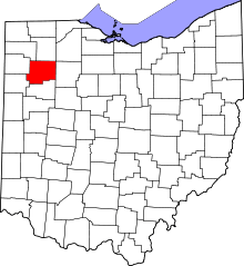 Location in the U.S. state of Ohio | ||
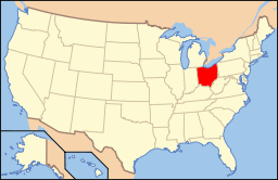 Ohio's location in the U.S. | ||
| Founded | January 3, 1834 | |
| Named for | Israel Putnam | |
| Seat | Ottawa | |
| Largest village | Ottawa | |
| Area | ||
| • Total | 484 sq mi (1,254 km2) | |
| • Land | 483 sq mi (1,251 km2) | |
| • Water | 1.8 sq mi (5 km2), 0.4% | |
| Population | ||
| • (2010) | 34,499 | |
| • Density | 71/sq mi (27/km²) | |
| Congressional district | 5th | |
| Time zone | Eastern: UTC-5/-4 | |
| Website |
www | |

Putnam County is a county located in the U.S. state of Ohio. As of the 2010 census, the population was 34,499.[1] Its county seat is Ottawa.[2] The county was created in 1820 and later organized in 1834.[3] Its name is in honor of Israel Putnam, who was a hero in the French and Indian War and a general in the American Revolutionary War.[4]
Geography
According to the U.S. Census Bureau, the county has a total area of 484 square miles (1,250 km2), of which 483 square miles (1,250 km2) is land and 1.8 square miles (4.7 km2) (0.4%) is water.[5]
Adjacent counties
- Henry County (north)
- Hancock County (east)
- Allen County (south)
- Van Wert County (southwest)
- Paulding County (west)
- Defiance County (northwest)
- Wood County (northeast, at a single point)
Demographics
| Historical population | |||
|---|---|---|---|
| Census | Pop. | %± | |
| 1830 | 230 | — | |
| 1840 | 5,189 | 2,156.1% | |
| 1850 | 7,221 | 39.2% | |
| 1860 | 12,808 | 77.4% | |
| 1870 | 17,081 | 33.4% | |
| 1880 | 23,713 | 38.8% | |
| 1890 | 30,188 | 27.3% | |
| 1900 | 32,525 | 7.7% | |
| 1910 | 29,972 | −7.8% | |
| 1920 | 27,751 | −7.4% | |
| 1930 | 25,074 | −9.6% | |
| 1940 | 25,016 | −0.2% | |
| 1950 | 25,248 | 0.9% | |
| 1960 | 28,331 | 12.2% | |
| 1970 | 31,134 | 9.9% | |
| 1980 | 32,991 | 6.0% | |
| 1990 | 33,819 | 2.5% | |
| 2000 | 34,726 | 2.7% | |
| 2010 | 34,499 | −0.7% | |
| Est. 2015 | 34,042 | [6] | −1.3% |
| U.S. Decennial Census[7] 1790-1960[8] 1900-1990[9] 1990-2000[10] 2010-2013[1] | |||
2000 census
As of the census[11] of 2000, there were 34,726 people, 12,200 households, and 9,308 families residing in the county. The population density was 72 people per square mile (28/km²). There were 12,753 housing units at an average density of 26 per square mile (10/km²). The racial makeup of the county was 96.26% White, 0.17% Black or African American, 0.15% Native American, 0.18% Asian, 0.01% Pacific Islander, 2.51% from other races, and 0.73% from two or more races. 4.38% of the population were Hispanic or Latino of any race.
There were 12,200 households out of which 39.20% had children under the age of 18 living with them, 64.90% were married couples living together, 7.40% had a female householder with no husband present, and 23.70% were non-families. 21.30% of all households were made up of individuals and 10.50% had someone living alone who was 65 years of age or older. The average household size was 2.81 and the average family size was 3.29.
In the county, the population was spread out with 29.70% under the age of 18, 8.30% from 18 to 24, 28.10% from 25 to 44, 20.60% from 45 to 64, and 13.30% who were 65 years of age or older. The median age was 35 years. For every 100 females there were 98.50 males. For every 100 females age 18 and over, there were 97.00 males.
The median income for a household in the county was $46,426, and the median income for a family was $52,859. Males had a median income of $36,548 versus $23,963 for females. The per capita income for the county was $18,680. About 4.00% of families and 5.60% of the population were below the poverty line, including 6.40% of those under age 18 and 9.80% of those age 65 or over.
2010 census
As of the 2010 United States Census, there were 34,499 people, 12,872 households, and 9,556 families residing in the county.[12] The population density was 71.5 inhabitants per square mile (27.6/km2). There were 13,731 housing units at an average density of 28.5 per square mile (11.0/km2).[13] The racial makeup of the county was 95.7% white, 0.3% black or African American, 0.2% Asian, 0.2% American Indian, 2.7% from other races, and 0.9% from two or more races. Those of Hispanic or Latino origin made up 5.5% of the population.[12] In terms of ancestry, 65.6% were German, 7.8% were Irish, and 7.3% were American.[14]
Of the 12,872 households, 35.0% had children under the age of 18 living with them, 62.9% were married couples living together, 7.4% had a female householder with no husband present, 25.8% were non-families, and 22.5% of all households were made up of individuals. The average household size was 2.66 and the average family size was 3.13. The median age was 39.0 years.[12]
The median income for a household in the county was $56,573 and the median income for a family was $65,882. Males had a median income of $44,417 versus $33,200 for females. The per capita income for the county was $24,023. About 5.8% of families and 7.1% of the population were below the poverty line, including 9.8% of those under age 18 and 7.0% of those age 65 or over.[15]
Politics
| Year | Republican | Democrat |
|---|---|---|
| 2016 | 79.34% 14,961 | 15.50% 2,922 |
| 2012 | 74.57% 13,721 | 23.47% 4,318 |
| 2008 | 69.98% 13,072' | 28.27% 5,281 |
| 2004 | 76.24% 14,370 | 23.30% 4,392 |
| 2000 | 74.01% 12,837 | 23.43% 4,063 |
Education
The Putnam County Board of Education operates nine separate school districts county-wide.
- Columbus Grove Local School District, Putnam County, Ohio
- St. Anthony's Elementary
- Continental Local School District, Putnam County, Ohio
- Fort Jennings Local School District, Putnam County, Ohio
- Kalida Local School District, Putnam County, Ohio
- Leipsic Local School District, Putnam County, Ohio
- Leipsic St. Mary's Elementary
- McComb Local School District, Hancock County, Ohio (mostly in Hancock County)
- Miller City-New Cleveland Local School District, Putnam County, Ohio
- Ottawa-Glandorf Local School District, Putnam County, Ohio
- St. Peter and Paul Elementary
- Loving Care Daycare and Preschool
- Ottawa-Glandorf Alternative School
- Ottoville Local School District, Putnam County, Ohio
- Pandora-Gilboa Local School District, Putnam County, Ohio
Other villages across the county are served by one or more of these districts above in the district's zone area.
Communities
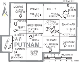
Villages
Townships
Census-designated place
Unincorporated communities
Putnam County Fair
The Putnam County Fair is located in Ottawa, Ohio and the slogan is "A Blue Ribbon Event." At the fairgrounds, there are several activities from playing games, to riding rides, or just eating the food. The Putnam County Fair usually runs the last week of June.
See also
Footnotes
- 1 2 "State & County QuickFacts". United States Census Bureau. Retrieved February 10, 2015.
- ↑ "Find a County". National Association of Counties. Retrieved 2011-06-07.
- ↑ "Ohio: Individual County Chronologies". Ohio Atlas of Historical County Boundaries. The Newberry Library. 2007. Retrieved February 14, 2015.
- ↑ Warren, Robert (May 31, 1953). "Blanchard River Brought Pioneers To Putnam". Toledo Blade. p. 3. Retrieved 30 April 2015.
- ↑ "2010 Census Gazetteer Files". United States Census Bureau. August 22, 2012. Retrieved February 10, 2015.
- ↑ "County Totals Dataset: Population, Population Change and Estimated Components of Population Change: April 1, 2010 to July 1, 2015". Retrieved July 2, 2016.
- ↑ "U.S. Decennial Census". United States Census Bureau. Retrieved February 10, 2015.
- ↑ "Historical Census Browser". University of Virginia Library. Retrieved February 10, 2015.
- ↑ Forstall, Richard L., ed. (March 27, 1995). "Population of Counties by Decennial Census: 1900 to 1990". United States Census Bureau. Retrieved February 10, 2015.
- ↑ "Census 2000 PHC-T-4. Ranking Tables for Counties: 1990 and 2000" (PDF). United States Census Bureau. April 2, 2001. Retrieved February 10, 2015.
- ↑ "American FactFinder". United States Census Bureau. Retrieved 2008-01-31.
- 1 2 3 "DP-1 Profile of General Population and Housing Characteristics: 2010 Demographic Profile Data". United States Census Bureau. Retrieved 2015-12-27.
- ↑ "Population, Housing Units, Area, and Density: 2010 - County". United States Census Bureau. Retrieved 2015-12-27.
- ↑ "DP02 SELECTED SOCIAL CHARACTERISTICS IN THE UNITED STATES – 2006-2010 American Community Survey 5-Year Estimates". United States Census Bureau. Retrieved 2015-12-27.
- ↑ "DP03 SELECTED ECONOMIC CHARACTERISTICS – 2006-2010 American Community Survey 5-Year Estimates". United States Census Bureau. Retrieved 2015-12-27.
- ↑ "Dave Leip's Atlas of U.S. Presidential Elections". Retrieved 2016-03-27.
Further reading
- Marguerite Calvin, Death, Administration, Marriage, and Miscellaneous Notices from the Kalida Venture, Putnam County, Ohio, 1845-1854. Ottawa, OH: Putnam County District Library, 1987.
- Marguerite Calvin, Newspaper Notices from the Kalida Venture, Putnam County, Ohio 1845-1852: A Supplement to Deaths, Administration, Marriage, and Miscellaneous Notices. Ottawa, OH: Putnam County District Library, 1993.
- Marguerite Calvin, Newspaper Notices from the Kalida Sentinel, Putnam County, Ohio, 1861-1866. Ottawa, OH: Putnam County District Library, 1991.
- Marguerite Calvin and David S. Adams, People and Places: Putnam County, Ohio, 1800-1900. Ottawa, OH: M. Calvin, 1981.
- Audrey S. Carroll, Putnam County Pioneer Association: Centennial History, 1873-1973, Putnam County, Ohio. Columbus Grove, OH: Heffner Printing Co., 1973.
- Imogene Elwer, Chronicles of the Past: A History of Putnam County, Ohio. n.c.: n.p., 1990s.
- Delbert L. Gratz, Historical and Genealogical Sketch of the Swiss Mennonites of Allen and Putnam Counties, Ohio. Columbus, OH: Ohio Historical Society, 1940.
- Henry Howe, History of Putnam County, Ohio, 1820-1899. Knightstown, IN: The Bookmark, 1977.
- George D. Kinder, History of Putnam Country, Ohio: Its Peoples, Industries, and Institutions: With Biographical Sketches of Representative Citizens and Genealogical Records of Many of the Old Families. Indianapolis, IN: B.F. Bowen and Co., 1915.
- Putnam County Genealogical Society, Putnam County, Ohio Cemeteries. Ottawa, OH: Putnam County Genealogical Society, 1993.
- Putnam County Historical Society, The Blizzard of 1978 in Putnam County, Ohio. Kalida, OH: Putnam County Historical Society, 1978.
- Putnam County Historical Society, History of Putnam County, Ohio, 1880: Illustrated, Containing Outline Map, Fifteen Farm Maps and a History of the County; Lithographic Views of Buildings — Public and Private; Portraits of Prominent Men; General statistics; Miscellaneous Matters, etc. Mt. Vernon, IN: Windmill Publications, 1995.
- Putnam County Historical Society, Putnam County Pioneer Reminiscences, 1878-1887. Kalida, OH: Putnam County Historical Society, 1981.
- Daniel W. Seitz and O.C. Talbot, The Putnam County Atlas, 1895: Containing Sectional Outline Maps of the County...Farm Maps of the Fifteen Townships...Together with Maps of All the Towns Reduced to Single Page Size... Ottawa, OH: D.W. Seitz and O.C. Talbot, 1895.
- Mary L. Sheeley, Putnam County, Ohio One-Room Schools. Kalida, OH: Putnam County Historical Society, 1985.
- Marjorie Waterfield, The Ledger Tells the Story, 1811-1879: The History of the Irwin family of Putnam County, Ohio. Bowling Green, OH: M. Waterfield, 1997.
- A Portrait and Biographical Record of Allen and Putnam Counties, Ohio: Containing Biographical Sketches of Many Prominent and Representative Citizens, Together with Biographies and Portraits of All the Presidents of the United States, and Biographies of the Governors of Ohio. Chicago: A.W. Bowen & Company, 1896.
External links
| Wikivoyage has a travel guide for Putnam County (Ohio). |
 |
Defiance County | Henry County | Wood County | |
| Paulding County | |
Hancock County | ||
| ||||
| | ||||
| Van Wert County | Allen County |
Municipalities and communities of Putnam County, Ohio, United States | ||
|---|---|---|
| Villages | | |
| Townships | ||
| CDP | ||
| Unincorporated communities | ||
| Ghost towns | ||
Coordinates: 41°01′N 84°08′W / 41.02°N 84.13°W