Ohio State Route 705
| ||||
|---|---|---|---|---|
 | ||||
| Route information | ||||
| Maintained by ODOT | ||||
| Length: | 28.85 mi[1] (46.43 km) | |||
| Existed: | 1937 – present | |||
| Major junctions | ||||
| West end: |
| |||
|
| ||||
| East end: |
| |||
| Location | ||||
| Counties: | Darke, Shelby | |||
| Highway system | ||||
| ||||

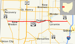
State Route 705 (SR 705) is a state highway in western Ohio, a U.S. state. The highway's western terminus is in rural northwestern Darke County at SR 49 approximately 5.25 miles (8.45 km) southeast of Fort Recovery, and just a mile south of the Darke-Mercer County Line. Its eastern terminus is at SR 29 nearly 2.75 miles (4.43 km) northwest of Sidney.
Established in the late 1930s, SR 705 connects the northern half of Darke County to the city of Sidney. The highway goes through rural areas in Darke County, passing through the villages of New Weston and Osgood heading east. The road follows very close to the Mercer County Line throughout Darke County. In Shelby County, Fort Loramie is the only village along the road.
Route description
Along its path, SR 705 travels through parts of the counties of Darke and Shelby. There are no stretches of this state route that are inclusive within the National Highway System.[2]
History
SR 705 was designated in 1937. The route has not experienced any major changes to its alignment since its inception.[3][4]
Major intersections
| County | Location | mi[1] | km | Destinations | Notes |
|---|---|---|---|---|---|
| Darke | Mississinawa Township | 0.00 | 0.00 | ||
| New Weston | 5.47 | 8.80 | |||
| Wabash Township | 9.03 | 14.53 | |||
| Osgood | 13.03 | 20.97 | Southern terminus of SR 716 | ||
| Darke–Shelby county line | Patterson–McLean township line | 16.47 | 26.51 | Southern terminus of SR 364 | |
| Shelby | Fort Loramie | 19.75 | 31.78 | ||
| Clinton Township | 28.85 | 46.43 | |||
| 1.000 mi = 1.609 km; 1.000 km = 0.621 mi | |||||
References
- 1 2 Ohio Department of Transportation. "Technical Services Straight Line Diagrams". Retrieved 2009-02-02.
- ↑ National Highway System: Ohio (PDF) (Map). Federal Highway Administration. December 2003. Retrieved 2010-12-26.
- ↑ Ohio State Map (Map). Ohio Department of Transportation. 1936.
- ↑ Ohio State Map (Map). Ohio Department of Transportation. 1937.