Sidney, Ohio
| Sidney, Ohio | |
|---|---|
| City | |
|
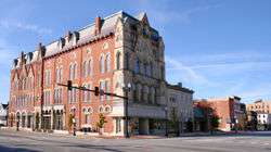
Sidney downtown, with the municipal courts in the Monumental Building. | |
| Motto: In God We Trust | |
 Location of Sidney, Ohio | |
 Location of Sidney in Shelby County | |
| Country | United States |
| State | Ohio |
| County | Shelby |
| Government | |
| • Mayor | Michael Barhorst |
| Area[1] | |
| • Total | 12.15 sq mi (31.47 km2) |
| • Land | 12.02 sq mi (31.13 km2) |
| • Water | 0.13 sq mi (0.34 km2) |
| Elevation[2] | 951 ft (290 m) |
| Population (2010)[3] | |
| • Total | 21,229 |
| • Estimate (2012[4]) | 21,031 |
| • Density | 1,766.1/sq mi (681.9/km2) |
| Time zone | Eastern (EST) (UTC-5) |
| • Summer (DST) | EDT (UTC-4) |
| ZIP codes | 45365, 45367 |
| Area code(s) | 937 |
| FIPS code | 39-72424[5] |
| GNIS feature ID | 1065321[2] |
| Website |
www |
Sidney is a city in Shelby County, Ohio, United States. The population was 21,229 at the 2010 census. It is named after English poet Sir Phillip Sidney and is the county seat of Shelby County.[6] As well, many of the city's elementary schools are also named after famous writers, such as Emerson, Longfellow and Whittier. Sidney was the recipient of the 1964 All-America City Award. In 2009, it was the subject of the documentary film 45365.[7]
Architecture
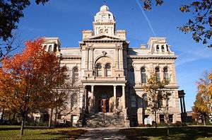
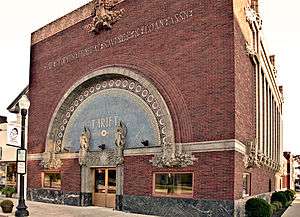
Sidney is home to the 1881 Second Empire courthouse; the 1877 Gothic revival Monumental Building, dedicated to the county's Civil War dead; the 1918 early-modern People's Federal Savings and Loan Association designed by influential architect Louis Sullivan, which has been designated a National Historic Landmark; and the "smallest house in Sidney" on Shelby Street.
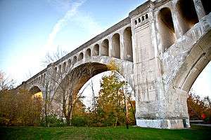
The Big Four Bridge is a local landmark that has carried rail traffic since 1923. CSX Transportation uses the rail line and bridge as part of the "NYC" division of Conrail, a direct descendant of the New York Central Railroad and Penn Central Transportation. CSX also operates the north-south rail line, which was better known in earlier years as the Baltimore and Ohio Railroad and later as the Chessie System.
The Graceland Cemetery features monuments and memorials of large concrete angels and other structures and statues.
Geography
According to the United States Census Bureau, the city has a total area of 12.15 square miles (31.47 km2), of which 12.02 square miles (31.13 km2) is land and 0.13 square miles (0.34 km2) is water.[1]
Demographics
| Historical population | |||
|---|---|---|---|
| Census | Pop. | %± | |
| 1830 | 240 | — | |
| 1840 | 713 | 197.1% | |
| 1850 | 1,302 | 82.6% | |
| 1860 | 2,055 | 57.8% | |
| 1870 | 2,808 | 36.6% | |
| 1880 | 3,823 | 36.1% | |
| 1890 | 4,850 | 26.9% | |
| 1900 | 5,688 | 17.3% | |
| 1910 | 6,607 | 16.2% | |
| 1920 | 8,590 | 30.0% | |
| 1930 | 9,301 | 8.3% | |
| 1940 | 9,790 | 5.3% | |
| 1950 | 11,491 | 17.4% | |
| 1960 | 14,663 | 27.6% | |
| 1970 | 16,332 | 11.4% | |
| 1980 | 17,658 | 8.1% | |
| 1990 | 18,710 | 6.0% | |
| 2000 | 20,211 | 8.0% | |
| 2010 | 21,229 | 5.0% | |
| Est. 2015 | 20,858 | [8] | −1.7% |
| Sources:[5][9][10][11] | |||
2010 census
As of the census[3] of 2010, there were 21,229 people, 8,344 households, and 5,577 families residing in the city. The population density was 1,766.1 inhabitants per square mile (681.9/km2). There were 9,265 housing units at an average density of 770.8 per square mile (297.6/km2). The racial makeup of the city was 90.3% White, 3.7% African American, 0.2% Native American, 1.6% Asian, 0.2% Pacific Islander, 0.8% from other races, and 3.3% from two or more races. Hispanic or Latino of any race were 2.2% of the population.
There were 8,344 households of which 35.4% had children under the age of 18 living with them, 45.7% were married couples living together, 15.2% had a female householder with no husband present, 6.0% had a male householder with no wife present, and 33.2% were non-families. 27.6% of all households were made up of individuals and 10.2% had someone living alone who was 65 years of age or older. The average household size was 2.51 and the average family size was 3.01.
The median age in the city was 36.1 years. 27.2% of residents were under the age of 18; 8.6% were between the ages of 18 and 24; 25.6% were from 25 to 44; 26.2% were from 45 to 64; and 12.4% were 65 years of age or older. The gender makeup of the city was 49.1% male and 50.9% female.
2000 census
As of the census[5] of 2000, there were 20,211 people, 7,981 households, and 5,371 families residing in the city. The population density was 1,938.5 people per square mile (748.2/km²). There were 8,557 housing units at an average density of 820.7 per square mile (316.8/km²). The racial makeup of the city was 92.61% White, 3.06% African American, 0.24% Native American, 1.87% Asian, 0.10% Pacific Islander, 0.40% from other races, and 1.73% from two or more races. Hispanic or Latino of any race were 1.30% of the population.
There were 7,981 households out of which 34.6% had children under the age of 18 living with them, 49.8% were married couples living together, 12.8% had a female householder with no husband present, and 32.7% were non-families. 27.4% of all households were made up of individuals and 10.3% had someone living alone who was 65 years of age or older. The average household size was 2.50 and the average family size was 3.03.
In the city the population was spread out with 28.1% under the age of 18, 9.1% from 18 to 24, 29.7% from 25 to 44, 21.3% from 45 to 64, and 11.9% who were 65 years of age or older. The median age was 34 years. For every 100 females there were 95.4 males. For every 100 females age 18 and over, there were 92.8 males.
The median income for a household in the city was $38,663, and the median income for a family was $45,672. Males had a median income of $35,127 versus $22,497 for females. The per capita income for the city was $19,075. About 9.4% of families and 11.5% of the population were below the poverty line, including 15.5% of those under age 18 and 7.9% of those age 65 or over.
Government
The city government is a council-manager system. The city council consists of a mayor and six members; three council members are elected at-large by all city voters, while the remaining four are elected from each of the four wards. All council members serve terms of four years. The mayor and vice-mayor are elected by the Council from their own number by a majority vote and serve terms of two years. The council meets the second and fourth Mondays of each month at 6:30 P.M. In addition to their bi-weekly meetings, council also meets the first Monday of each month in workshop sessions. Most meetings are held in the municipal building's council chambers.
Council members include Mayor Mike Barhorst (At Large), Mike Burns (Fourth Ward), Katie McMillan (Second Ward), Frank Mariano (At Large), Tom Miller (Third Ward), Vice Mayor Mardie Milligan (First Ward) and Terry Pellman (At Large).
History
From the 1840s to 1913, canal boats carried Shelby County's products to Cincinnati or Toledo. Sidney was crossed by the Miami and Erie Canal's Sidney or Port Jefferson Feeder Branch. Before railroads came to Sidney, the canal provided most transportation, as roads were unpaved and not usable in all seasons. Part of the canal remains south of Water Street.
The City of Sidney, named after Sir Philip Sidney, a well-known poet and member of British Parliament, was originally a 70-acre (280,000 m2) parcel of land located along the west side of the Great Miami River. This land was donated by Charles Starrett to be used as the site of a new town designated to be the county seat of Shelby County. The area around Sidney was once the richly-forested hunting ground of the Shawnee and Miami Indian nations. This fertile area was developed as agricultural lands over time.
The construction of the Miami-Erie Canal between 1825 and 1837 connected Sidney in a north/south direction with the major trade centers in Ohio. In addition to opening the first significant "outside" trade for Sidney, the construction of the canal attracted an influx of settlers to the area.
As the influence of the canal declined, another transportation element, railroads, began to develop in Sidney. East-west rail began to be laid in 1851, followed by north-south rail in 1856. Sidney is still served by these railroad lines.
In the 1950s, the Interstate Highway contributed to the development of Sidney. It was named as "All-America City" in 1964. Today, Interstate 75 connects Sidney with Canada to the north, and Florida to the south. Sidney has four interchanges with Interstate 75, providing access for both commercial and industrial users.
Sidney is located 40 miles (64 km) north of Dayton, 85 miles (137 km) west of Columbus, 100 miles (160 km) south of Toledo, and 120 miles (190 km) east of Indianapolis. Sidney offers an historic downtown featuring the famous Louis Sullivan-designed People's Savings & Loan building, the Monumental Building (erected as a memorial to county residents who had died in the Civil War), and the Shelby County Courthouse. The Courthouse, which occupies one city-block known as Court Square, was recently named by the National Trust for Historic Preservation as one of the "Great American Public Places".
Sidney has an extensive parks and recreation system. When the City's first comprehensive plan was being developed in the mid-1950s, the City decided to have a park or recreation area within a half-mile of every residence. This goal has resulted in a system of 14 neighborhood parks, a baseball complex, softball complex, soccer complex, municipal swimming pool, and the 180-acre (0.73 km2) Tawawa Park, a nature and picnic area.
Sidney is the hometown of Paul Lauterbur, a renowned scientist and Nobel Prize winner who helped develop the MRI.
In 1984, President Ronald Reagan visited the city of Sidney on a train (the same train that President Franklin D. Roosevelt used during his visit to Sidney in 1944) while touring the country. President George W. Bush visited the town in 2004, eating at the Spot Restaurant in downtown Sidney. Republican presidential candidate Mitt Romney visited the Shelby County Fairgrounds in Sidney in 2012.
Sidney, Iowa derives its name from the community.[12]
The town of Buckeye, Arizona was originally named after Sidney. Malin M. Jackson, who built Arizona's Buckeye Canal, was from Sidney.[13]
Economy
Sidney is the headquarters location for many companies and a branch location for many others. Many companies were formed in Sidney and continued to be operated by local residents. A diversified employer base offers jobs in manufacturing (especially in the automotive industry) and service sectors. In addition to the Sidney-based employers, Honda of America Anna engine plant, 7 miles north of Sidney, is the single largest employer in Shelby County, with 2400 associates. Amos Press of Sidney publishes Coin World, Linn's Stamp News and other nationally distributed hobby publications. The agricultural base in the area has commodity grain, livestock, and dairy activities.
Entertainment and activities
Sidney, Ohio has a drive-in movie theatre, the Auto-Vue, located on the corner of 4th Street and Russell Road. The drive-in opens in May and closes in September. During the fall season, a large corn maze is created on the south side of town. The area has a driving range for golfers and a zip line.
In recent years, Kevin Frazier-Jones and other community theater leaders have revamped the Sidney Theatre downtown as a venue for live performance. This building is particularly popular with local area music and drama productions.
The Shelby County Historical Society operates the William A. Ross Junior Historical Society at 201 N. Main Street in Sidney. A collection of Sidney and Shelby County historical artifacts is available for viewing Monday through Friday, 1-5 PM and Saturday 9 AM - noon. It is closed on Sunday and holidays.
The annual Country Concert is held at Newport, Ohio the 2nd week of July. Many country and western stars have played there over the years.
For the outdoor enthusiast, State Parks include Lake Loramie, Kiser Lake, Indian Lake, and Grand Lake St Marys. They are easy drives from Sidney. Camping, boating, hunting and fishing are common pursuits in the area.
Sports
Sidney High School sports teams are known as the Yellow Jackets. The Yellow Jackets football team went 10-0 three straight seasons from 1968-1970 for a 30-0 record. The 1989 Yellow Jackets football team went 9-4 and made it to the Final Four in Division II. When the school built a new stadium in 2004, it was named Sidney Memorial Stadium at 30 & O Field. The stadium is located on 4th Avenue between Campbell Road and Fair Road, east of Emerson Climate Technologies: Copeland Corporation. Sidney Memorial Stadium also hosts home games for the Lehman Catholic High School's Cavaliers.
Transportation
Air

Sidney is served by the Sidney Municipal Airport. Dayton International Airport is 35 miles (56 km) south while Port Columbus which serves Columbus is 106 miles (171 km) east.
Rail
Sidney has two railroad lines. Both were built independently in the 1850s.
Until the 1960s, passengers could take the Knickerbocker Limited from Sidney to Grand Central Terminal in New York City. This east-west line was built as the Bellefontaine and Indiana Railroad which ran from Galion, Ohio to Union City on the Ohio-Indiana border. It was built in conjunction with the Indianapolis and Bellefontaine Railroad, providing a route between Cleveland and the East and Indianapolis, and later St. Louis. In 1864, the two were merged into the "Bee" Line: the Bellefontaine Railway. In 1869, the lines were merged into the first "Big Four": the Cleveland, Columbus, Cincinnati and Indianapolis Railway. In 1889, the second "Big Four" was formed: the Cleveland, Cincinnati, Chicago and St. Louis Railway. In the early 1920s, this railroad relocated its tracks from downtown Sidney to the south edge of the city over the new Big Four concrete arch bridge. Early in the twentieth century, it was leased by the New York Central System. Later the Big Four was taken over by the Penn Central, then Conrail, and finally CSX Transportation.
Other concrete arch bridges in the region were designed and built for the Big Four; they are located in Avon and Greencastle, Indiana, and Danville, Illinois.
In the 1950s, passengers could board a train in Sidney and take it south to Cincinnati or New Orleans. This north-south line was built as the Dayton and Michigan Railroad. In the 1860s it was leased by the Cincinnati, Hamilton and Dayton Railroad. It was taken over by the Baltimore and Ohio Railroad early in the twentieth century. Later the line was taken over by the Chesapeake and Ohio Railroad, then by CSX Transportation, and passenger services were reduced.
Highway system
The Dixie Highway, later US 25, now known as County Rd 25A, ran north/south through downtown Sidney, connecting it with Toledo and Detroit to the north and Dayton and Cincinnati to the south. Interstate 75 was completed in the early '60s. Located west of Sidney, it took the place of the Dixie Highway and most of the traffic. Four exits from I-75 provide direct access to Sidney: exit 90 (Fair Road), exit 92 (State Route 47), exit 93 (State Route 29), and exit 94 (County Road 25A).
Media
- The Sidney Daily News is published each day of the week except Sunday and Tuesday.[14]
- WMVR-FM broadcasts hot adult contemporary programming on 105.5 FM.
- Scores Broadcast a webcaster offering live high school sports coverage www.scoresbroadcast.com
- KLOVE 94.1 FM (translator W231AZ)
- WHJM 88.7 FM "Radio Maria"
Largest employers (companies with over 100 employees)
- Emerson Climate Technologies, Inc.
- Wilson Memorial Hospital
- Shelby County Commissioners
- NK Parts
- Sidney Board of Education
- American Trim, LLC
- Ohio Department of Transportation
- Cargill, Inc.
- Holloway Sportswear, Inc.
- Freshway Foods, Inc.
- Wal-mart Stores, Inc.
- City of Sidney
- Clean All Services
- International Automotive Components
- Area Energy & Electric
- Mama Rosa Foods
- Ferguson Construction Company, Inc.
- Ross Casting & Innovation LLC
- Advanced Composites, Inc.
- Fair Haven Shelby County Home
- Norcold, Inc.
- Energizer, Playtex Business Unit
- Alcoa Home Exteriors, Inc.
- Peerless Machinery Corp.
- Ross Aluminum Castings, LLC.
- Formed Fiber Technologies
- Hydro Aluminum North America, Inc.
- Amos Press, Inc.
- The Kroger Company
- Continental Express, Inc.
- Sidney Tool & Die Company
- Sidney-Shelby County YMCA
- Dickman Supply Inc
- Reliable Castings Corporation
- Dorothy Love Retirement Community
- Source: City of Sidney Economic Development Comprehensive Plan Update - 2009
Notable people
- John Foley Horr - Civil War Captain with the 2nd Ohio Volunteer Infantry. Appointed by President Harrison as Collector of Customs for the Port of Key West. Appointed under President McKinley and again by President Roosevelt as a Federal Marshall. Buried in Sidney.
- Paul Christian Lauterbur, chemist and Nobel Prize laureate
- Joey J. Long, former Major League Baseball pitcher for the San Diego Padres
- Louis H. Mackey, philosopher, Kierkegaard scholar, literary critic
- Dean Miller, actor and radio station owner
References
- 1 2 "US Gazetteer files 2010". United States Census Bureau. Retrieved 2013-01-06.
- 1 2 "US Board on Geographic Names". United States Geological Survey. 2007-10-25. Retrieved 2008-01-31.
- 1 2 "American FactFinder". United States Census Bureau. Retrieved 2013-01-06.
- ↑ "Population Estimates". United States Census Bureau. Retrieved 2013-06-17.
- 1 2 3 "American FactFinder". United States Census Bureau. Retrieved 2008-01-31.
- ↑ "Find a County". National Association of Counties. Retrieved 2011-06-07.
- ↑ 45365 at the Internet Movie Database
- ↑ "Annual Estimates of the Resident Population for Incorporated Places: April 1, 2010 to July 1, 2015". Retrieved July 2, 2016.
- ↑ "Number of Inhabitants: Ohio" (PDF). 18th Census of the United States. U.S. Census Bureau. Retrieved 22 November 2013.
- ↑ "Ohio: Population and Housing Unit Counts" (PDF). U.S. Census Bureau. Retrieved 22 November 2013.
- ↑ "Incorporated Places and Minor Civil Divisions Datasets: Subcounty Population Estimates: April 1, 2010 to July 1, 2012". U.S. Census Bureau. Retrieved 25 November 2013.
- ↑ Sidney History - sidneyia.net
- ↑ Buckeye Valley History. Official website of the Town of Buckeye, retrieved June 29, 2006.
- ↑ "Three Ohio newspapers end Tuesday editions". The Columbus Dispatch. February 3, 2009. Retrieved December 15, 2010.
External links
| Wikimedia Commons has media related to Sidney, Ohio. |
Municipalities and communities of Shelby County, Ohio, United States | ||
|---|---|---|
| City |  | |
| Villages | ||
| Townships | ||
| CDP | ||
| Unincorporated communities | ||