Ohio State Route 86
| ||||
|---|---|---|---|---|
 | ||||
| Route information | ||||
| Maintained by ODOT | ||||
| Length: | 21.98 mi[1] (35.37 km) | |||
| Existed: | 1923 – present | |||
| Major junctions | ||||
| West end: |
| |||
| East end: |
| |||
| Location | ||||
| Counties: | Lake, Geauga, Ashtabula | |||
| Highway system | ||||
| ||||

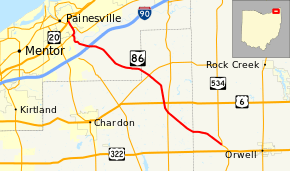
State Route 86 (SR 86) is an east–west state highway in the northeastern portion of the U.S. state of Ohio. Running more southeast-northwest, its western terminus is at US 20 in Painesville, and its eastern terminus is at SR 534 near Windsor.
SR 86 does not have an interchange with Interstate 90 but motorists can access I-90's Exit 205 in LeRoy Township via a county road.
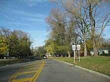
The "NORTH" sign has since been replaced with a "WEST" sign
A significant section of SR 86 was rerouted south of Painesville 2007–2008 in a project[2] proposed since the early 1980s.[3] The southern portion of this section, just north of I-90, was rerouted during the 2007 construction season, and the northern, bypassing a section with a history of slope sliding, in 2008, with the road opening in full on October 31.[4][5][6] The SR 84/86 overlap was subsequently extended approximately a half-mile.
Prior to August 17, 2007, SR 86 overlapped with SR 534 from their intersection to US 322 in Windsor. That overlap has since been removed, with that stretch of road becoming solely SR 534.[7]
History
- 1923 – Original route established;[8] no significant changes since its certification.[9]
- 2007 - Southern end truncated at SR 534 northwest of Windsor.[7]
- 2008 - Rerouted near north end, overlap with SR 84 lengthened.[2][4]
Major intersections
| County | Location | mi[1] | km | Destinations | Notes |
|---|---|---|---|---|---|
| Lake | Painesville | 0.00 | 0.00 | ||
| 0.84 | 1.35 | Western end of SR 84 concurrency | |||
| 1.64 | 2.64 | Eastern end of SR 84 concurrency | |||
| Geauga | Thompson Township | 10.97 | 17.65 | ||
| Montville Township | 14.38 | 23.14 | |||
| 15.42 | 24.82 | ||||
| Ashtabula | Windsor Township | 21.98 | 35.37 | ||
1.000 mi = 1.609 km; 1.000 km = 0.621 mi
| |||||
References
- 1 2 "Division of Planning - Office of Technical Services - Destape files". ODOT. July 16, 2013. Retrieved February 15, 2014 — Lake County, Geauga County, Ashtabula County
- 1 2 SR 86 Relocation Information. Ohio Department of Transportation District 12.
- ↑ Scott, Mark (2001-06-21). "All quiet at meeting on Route 86 plan". The News-Herald. Retrieved 2009-03-23.
- 1 2 "State Route 86 reopens" (Press release). Ohio Department of Transportation District 12. 2008-10-31. Retrieved 2014-09-25.
- ↑ Jones, David W. (2008-10-30). "Route 86 to reopen in Concord Township.". The News-Herald. Retrieved 2009-03-19.
- ↑ Horton, John (2008-11-03). "Road Rant: Willoughby Hills reacts in timely manner to slow traffic signal". The Plain Dealer. Retrieved 2009-03-19.
- 1 2 "Ashtabula County Updates: 2008". Ohio Department of Transportation. Retrieved 2009-07-11.
- ↑ Explanation of the Ohio State Highway System (The Unofficial Ohio State Highways Web Site) by John Simpson Archived May 23, 2006, at the Wayback Machine.
- ↑ Route 86 (The Unofficial Ohio State Highways Web Site) by John Simpson Archived October 31, 2004, at the Wayback Machine.