Lake County, Ohio
| Lake County, Ohio | ||
|---|---|---|
|
Lake County Courthouse | ||
| ||
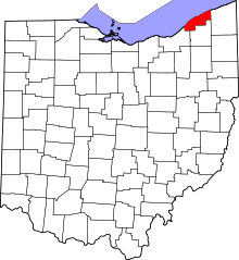 Location in the U.S. state of Ohio | ||
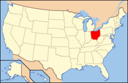 Ohio's location in the U.S. | ||
| Founded | March 6, 1840[1] | |
| Named for | Lake Erie | |
| Seat | Painesville | |
| Largest city | Mentor | |
| Area | ||
| • Total | 979 sq mi (2,536 km2) | |
| • Land | 227 sq mi (588 km2) | |
| • Water | 752 sq mi (1,948 km2), 77% | |
| Population | ||
| • (2010) | 230,041 | |
| • Density | 1,011/sq mi (390/km²) | |
| Congressional district | 14th | |
| Time zone | Eastern: UTC-5/-4 | |
| Website |
www | |


Lake County is a county located in the U.S. state of Ohio. As of the 2010 census, the population was 230,041.[2] The county seat is Painesville.[3] The county was established on March 6, 1840, from land given by Cuyahoga and Geauga Counties. Its name is derived from its location on the southern shore of Lake Erie.[4]
Lake County is part of the Cleveland-Elyria, OH Metropolitan Statistical Area.
History
After the discovery of the New World, the land that became Lake County was originally part of the French colony of Canada (New France), which was ceded in 1763 to Great Britain and renamed Province of Quebec. In the late 18th century the land became part of the Connecticut Western Reserve in the Northwest Territory, then was purchased by the Connecticut Land Company in 1795.
Geography
According to the U.S. Census Bureau, the county has a total area of 979 square miles (2,540 km2), of which 227 square miles (590 km2) is land and 752 square miles (1,950 km2) (77%) is water.[5] It is the smallest county in Ohio by land area but the third-largest by total area. It borders Ontario across Lake Erie.
Adjacent counties
- Elgin County, Ontario, Canada (north)
- Ashtabula County (east)
- Geauga County (south)
- Cuyahoga County (south and west)
National protected area
Demographics
| Historical population | |||
|---|---|---|---|
| Census | Pop. | %± | |
| 1840 | 13,719 | — | |
| 1850 | 14,654 | 6.8% | |
| 1860 | 15,576 | 6.3% | |
| 1870 | 15,935 | 2.3% | |
| 1880 | 16,326 | 2.5% | |
| 1890 | 18,235 | 11.7% | |
| 1900 | 21,680 | 18.9% | |
| 1910 | 22,927 | 5.8% | |
| 1920 | 28,667 | 25.0% | |
| 1930 | 41,674 | 45.4% | |
| 1940 | 50,020 | 20.0% | |
| 1950 | 75,979 | 51.9% | |
| 1960 | 148,700 | 95.7% | |
| 1970 | 197,200 | 32.6% | |
| 1980 | 212,801 | 7.9% | |
| 1990 | 215,499 | 1.3% | |
| 2000 | 227,511 | 5.6% | |
| 2010 | 230,041 | 1.1% | |
| Est. 2015 | 229,245 | [6] | −0.3% |
| U.S. Decennial Census[7] 1790-1960[8] 1900-1990[9] 1990-2000[10] 2010-2013[2] | |||
In 2010, 92.4% spoke English, 2.7% Spanish, and 1.4% Croatian.[11]
2000 census
As of the census[12] of 2000, there were 227,511 people, 89,700 households, and 62,520 families residing in the county. The population density was 997 people per square mile (385/km²). There were 93,487 housing units at an average density of 410 per square mile (158/km²). The racial makeup of the county was 95.40% White, 1.99% Black or African American, 0.11% Native American, 0.90% Asian, 0.02% Pacific Islander, 0.66% from other races, and 0.92% from two or more races. 1.70% of the population were Hispanic or Latino of any race. 18.5% were of German, 14.6% Italian, 12.7% Irish, 8.1% English, 6.2% Polish, 5.7% American and 5.4% Slovene ancestry according to Census 2000. 93.6% spoke English, 1.9% Spanish, and 0.8% Croatian as their first language.[11]
There were 89,700 households out of which 31.10% had children under the age of 18 living with them, 56.10% were married couples living together, 10.00% had a female householder with no husband present, and 30.30% were non-families. 25.60% of all households were made up of individuals and 9.80% had someone living alone who was 65 years of age or older. The average household size was 2.50 and the average family size was 3.03.
In the county, the population was spread out with 24.20% under the age of 18, 7.30% from 18 to 24, 29.70% from 25 to 44, 24.70% from 45 to 64, and 14.10% who were 65 years of age or older. The median age was 39 years. For every 100 females there were 94.50 males. For every 100 females age 18 and over, there were 91.50 males.
The median income for a household in the county was $48,763, and the median income for a family was $57,134. Males had a median income of $40,916 versus $28,434 for females. The per capita income for the county was $23,160. About 3.50% of families and 5.10% of the population were below the poverty line, including 6.50% of those under age 18 and 5.40% of those age 65 or over.
2010 census
As of the 2010 United States Census, there were 230,041 people, 94,156 households, and 62,384 families residing in the county.[13] The population density was 1,011.2 inhabitants per square mile (390.4/km2). There were 101,202 housing units at an average density of 444.9 per square mile (171.8/km2).[14] The racial makeup of the county was 92.5% white, 3.2% black or African American, 1.1% Asian, 0.1% American Indian, 1.6% from other races, and 1.5% from two or more races. Those of Hispanic or Latino origin made up 3.4% of the population.[13] In terms of ancestry, 26.4% were German, 18.9% were Irish, 16.4% were Italian, 11.5% were English, 7.6% were Polish, 5.4% were Hungarian, and 3.9% were American.[15]
Of the 94,156 households, 29.4% had children under the age of 18 living with them, 50.5% were married couples living together, 11.2% had a female householder with no husband present, 33.7% were non-families, and 28.3% of all households were made up of individuals. The average household size was 2.41 and the average family size was 2.97. The median age was 42.3 years.[13]
The median income for a household in the county was $54,896 and the median income for a family was $67,206. Males had a median income of $49,240 versus $36,906 for females. The per capita income for the county was $28,221. About 6.0% of families and 8.1% of the population were below the poverty line, including 13.0% of those under age 18 and 4.4% of those age 65 or over.[16]
Environment
Scorecard[17] report from 2002 ranks Lake County among the worst 10% of counties in the U.S. in terms of cancer risk, developmental and reproductive toxicants, and other categories as well; this is comparable with most major cities and densely populated areas. Scorecard[18] In 2004, this county ranked among the cleanest/best 10% of all counties in the U.S. in terms of the number of designated Superfund sites.
Lake County has a large public park system. Kirtland is home to the Holden Arboretum and the location of Gildersleeve Mountain. Headlands Beach State Park is located in Mentor. The Grand River is a state wild and scenic river and the Chagrin River is a state scenic river.
Transportation
Laketran is the transit agency servicing Lake County. Interstate 90 runs northeast/southwest through Lake County, roughly parallel to State Route 2; together these roads make up the major traffic arteries in the county. There is currently no passenger rail service in Lake County, though Amtrak's New York City-Chicago "Lake Shore Limited" service schedules an eastbound and westbound train through Lake County nightly with stops at Cleveland and Erie. Railroad Main Line through-freight service is provided by CSXT (former Conrail, née-Penn Central, née-New York Central) and Norfolk Southern (née-Norfolk & Western, née-Nickel Plate Road). The recently formed Grand River Railroad, operating on former Baltimore & Ohio track, serves the Fairport Harbor area linking the Morton Salt plant with CSXT at Painesville.
Library services
Lake County is served by the following libraries:
- Fairport Harbor Public Library in Fairport Harbor
- Kirtland Public Library in Kirtland
- Madison Public Library in Madison
- Mentor Public Library in Mentor
- Morley Library in Painesville
- Perry Public Library in Perry
- Wickliffe Public Library in Wickliffe. WKPL is "A Top Ten American Library" as rated by the HAPLR Index.[19] In 2005, the library loaned more than 459,000 items to its 110,400 cardholders. Total holdings are over 100,000 volumes with over 519 periodical subscriptions.[20]
- Willoughby-Eastlake Public Library, headquartered in Willowick with branches in Eastlake, Willoughby, and Willoughby Hills. In 2005, the library loaned more than 1.2 million items to its 37,000 cardholders. Total holding are over 216,000 volumes with over 850 periodical subscriptions.[20]
Politics
| Year | Republican | Democratic |
|---|---|---|
| 2016 | 54.9% 62,627 | 39.5% 45,056 |
| 2012 | 49.5% 58,744 | 48.6% 57,680 |
| 2008 | 48.6% 59,142 | 49.5% 60,155 |
| 2004 | 51.1% 62,193 | 48.5% 59,049 |
| 2000 | 50.5% 51,747 | 45.3% 46,497 |
| 1996 | 41.9% 40,974 | 44.2% 43,186 |
| 1992 | 38.5% 40,766 | 35.6% 37,682 |
| 1988 | 56.6% 52,963 | 42.4% 39,667 |
| 1984 | 59.9% 54,587 | 39.8% 36,711 |
| 1980 | 50.3% 43,485 | 40.8% 35,246 |
| 1976 | 45.8% 36,390 | 51.3% 40,734 |
| 1972 | 58.9% 42,488 | 38.2% 27,523 |
| 1968 | 43.4% 28,450 | 42.6% 27,932 |
| 1964 | 37.7% 23,282 | 62.3% 38,552 |
| 1960 | 48.9% 32,038 | 51.1% 33,425 |
Lake County is known as a "purple" or "swing" county within the state. A 2008 analysis of Ohio presidential election results from 1960 to 2004 found that no other county more closely follows the statewide Ohio voting pattern.[22] Lake County doesn't always vote with the winner, but consistently is closer to the winner's Ohio vote percentage than any other Ohio county.
Communities

Cities
Villages
Townships
Census-designated place
Unincorporated communities
See also
- Melon heads - a local urban legend
- National Register of Historic Places listings in Lake County, Ohio
References
- ↑ "Ohio County Profiles: Lake County" (PDF). Ohio Department of Development. Retrieved 2007-04-28.
- 1 2 "State & County QuickFacts". United States Census Bureau. Retrieved February 8, 2015.
- ↑ "Find a County". National Association of Counties. Archived from the original on 2011-05-31. Retrieved 2011-06-07.
- ↑ "Lake County data". Ohio State University Extension Data Center. Retrieved 2007-04-28.
- ↑ "2010 Census Gazetteer Files". United States Census Bureau. August 22, 2012. Retrieved February 8, 2015.
- ↑ "County Totals Dataset: Population, Population Change and Estimated Components of Population Change: April 1, 2010 to July 1, 2015". Retrieved July 2, 2016.
- ↑ "U.S. Decennial Census". United States Census Bureau. Archived from the original on May 11, 2015. Retrieved February 8, 2015.
- ↑ "Historical Census Browser". University of Virginia Library. Retrieved February 8, 2015.
- ↑ Forstall, Richard L., ed. (March 27, 1995). "Population of Counties by Decennial Census: 1900 to 1990". United States Census Bureau. Retrieved February 8, 2015.
- ↑ "Census 2000 PHC-T-4. Ranking Tables for Counties: 1990 and 2000" (PDF). United States Census Bureau. April 2, 2001. Retrieved February 8, 2015.
- 1 2 "Archived copy". Archived from the original on 2013-08-15. Retrieved 2013-08-07.
- ↑ "American FactFinder". United States Census Bureau. Archived from the original on 2013-09-11. Retrieved 2008-01-31.
- 1 2 3 "DP-1 Profile of General Population and Housing Characteristics: 2010 Demographic Profile Data". United States Census Bureau. Retrieved 2015-12-27.
- ↑ "Population, Housing Units, Area, and Density: 2010 - County". United States Census Bureau. Retrieved 2015-12-27.
- ↑ "DP02 SELECTED SOCIAL CHARACTERISTICS IN THE UNITED STATES – 2006-2010 American Community Survey 5-Year Estimates". United States Census Bureau. Retrieved 2015-12-27.
- ↑ "DP03 SELECTED ECONOMIC CHARACTERISTICS – 2006-2010 American Community Survey 5-Year Estimates". United States Census Bureau. Retrieved 2015-12-27.
- ↑ scorecard.org
- ↑ scorecard.org
- ↑ "HAPLR Top Ten by Population". HAPLR Index.
- 1 2 "2005 Ohio Public Library Statistics:Statistics by County and Town". State Library of Ohio. Archived from the original on September 24, 2006. Retrieved October 28, 2006.
- ↑ http://uselectionatlas.org/
- ↑ Exner, Rich (August 19, 2008). "Ohio's presidential election bellwether: Lake County". Cleveland Plain Dealer. Retrieved June 24, 2012.
External links
| Wikimedia Commons has media related to Lake County, Ohio. |
 |
Lake Erie | | ||
| |
Ashtabula County | |||
| ||||
| | ||||
| Cuyahoga County | Geauga County |
Municipalities and communities of Lake County, Ohio, United States | ||
|---|---|---|
| Cities | | |
| Villages | ||
| Townships | ||
| CDP | ||
| Unincorporated communities | ||
Coordinates: 41°49′N 81°14′W / 41.82°N 81.24°W