Orani, Bataan
| Orani | ||
|---|---|---|
| Municipality | ||
 | ||
| ||
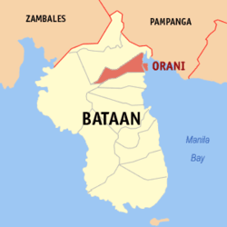 Location within Bataan province | ||
.svg.png) Orani Location within the Philippines | ||
| Coordinates: 14°48′N 120°32′E / 14.8°N 120.53°ECoordinates: 14°48′N 120°32′E / 14.8°N 120.53°E | ||
| Country | Philippines | |
| Region | Central Luzon (Region III) | |
| Province | Bataan | |
| District | 1st District of Bataan | |
| Founded | 1891 | |
| Barangays | 29 (see Barangays) | |
| Government [1] | ||
| • Type | Sangguniang Bayan | |
| • Mayor | Benjamin C. Serrano Jr. (Nacionalista) | |
| • Vice Mayor | Godofredo B. Galicia Jr. (Nacionalista) | |
| Area[2] | ||
| • Total | 64.9 km2 (25.1 sq mi) | |
| Population (2015 census)[3] | ||
| • Total | 66,909 | |
| • Density | 1,000/km2 (2,700/sq mi) | |
| • Voter (2016)[4] | 45,655 | |
| Time zone | PST (UTC+8) | |
| ZIP code | 2108 | |
| IDD : area code | +63 (0)47 | |
| Income class | 1st class | |
| PSGC | 030809000 | |

Orani, officially the Municipality of Orani (Filipino: Bayan ng Orani), is a municipality in the province of Bataan in the Central Luzon (Region III) of the Philippines. The population was 66,909 at the 2015 census.[3] In the 2016 election, it had 45,655 registered voters.[4]
Orani is located 107 kilometres (66 mi) north-west of Manila and accessible via the Bataan Provincial Expressway, off Exit 20. It is bounded on the north by Hermosa, south by Samal, west by Dinalupihan and east by the Manila Bay. It has a total land area of 64.9 square kilometres (25.1 sq mi) covering 29 barangays. About 1,231 hectares (3,040 acres) are used for agriculture, 1,943.86 hectares (4,803.4 acres) are forestland, 971.93 hectares (2,401.7 acres) are forest reservation and 1,295.9 hectares (3,202 acres) are reserved for the National Park. The rest are classified as wetland.
Palay, coffee, vegetables, peanut, citrus trees and fruit trees are the major produce. Cutflowers like aster, chrysanthemum and gerbera are locally cultivated while bamboo and jungle vines can be gathered from Orani's forestlands. Aquamarine resources like milkfish, tilapia, prawn, crabs, mussels and oysters are caught in Orani's fishing grounds and fishponds.
Geography
Orani is located at 14°48′N 120°32′E / 14.8°N 120.53°E.
According to the Philippine Statistics Authority, the municipality has a land area of 64.9 square kilometres (25.1 sq mi)[2] constituting 4.73% of the 1,372.98-square-kilometre- (530.11 sq mi) total area of Bataan.
Barangays
Orani is politically subdivided into 20 barangays.[5]
| PSGC | Barangay | Population | ±% p.a. | ||
|---|---|---|---|---|---|
| 2015[3] | 2010[6] | ||||
| 030809025 | Apollo | 2.9% | 1,955 | 1,857 | +0.98% |
| 030809001 | Bagong Paraiso (Poblacion) | 4.2% | 2,835 | 2,276 | +4.27% |
| 030809002 | Balut (Poblacion) | 2.0% | 1,355 | 1,397 | −0.58% |
| 030809003 | Bayan (Poblacion) | 9.0% | 6,018 | 5,363 | +2.22% |
| 030809004 | Calero (Poblacion) | 2.1% | 1,438 | 1,686 | −2.98% |
| 030809016 | Centro I (Poblacion) | 0.7% | 501 | 404 | +4.18% |
| 030809006 | Centro II (Poblacion) | 0.6% | 431 | 400 | +1.43% |
| 030809007 | Dona | 1.9% | 1,249 | 1,213 | +0.56% |
| 030809026 | Kabalutan | 3.7% | 2,462 | 2,099 | +3.08% |
| 030809008 | Kaparangan | 4.5% | 3,021 | 3,123 | −0.63% |
| 030809027 | Maria Fe | 3.2% | 2,146 | 2,046 | +0.91% |
| 030809009 | Masantol | 1.0% | 690 | 736 | −1.22% |
| 030809010 | Mulawin | 6.5% | 4,380 | 3,534 | +4.17% |
| 030809011 | Pag‑asa | 3.7% | 2,486 | 1,927 | +4.97% |
| 030809005 | Paking‑Carbonero (Poblacion) | 1.7% | 1,164 | 1,272 | −1.68% |
| 030809012 | Palihan (Poblacion) | 3.9% | 2,581 | 2,452 | +0.98% |
| 030809013 | Pantalan Bago (Poblacion) | 3.4% | 2,250 | 2,130 | +1.05% |
| 030809014 | Pantalan Luma (Poblacion) | 8.3% | 5,563 | 5,026 | +1.95% |
| 030809015 | Parang Parang (Poblacion) | 2.1% | 1,407 | 1,265 | +2.05% |
| 030809028 | Puksuan | 1.0% | 645 | 661 | −0.47% |
| 030809017 | Sibul | 1.9% | 1,283 | 1,084 | +3.26% |
| 030809018 | Silahis | 0.8% | 510 | 484 | +1.00% |
| 030809029 | Tagumpay | 3.0% | 2,003 | 1,833 | +1.70% |
| 030809019 | Tala | 2.2% | 1,467 | 1,337 | +1.78% |
| 030809020 | Talimundoc | 3.7% | 2,493 | 2,135 | +3.00% |
| 030809021 | Tapulao | 7.5% | 5,023 | 4,745 | +1.09% |
| 030809022 | Tenejero (Poblacion) | 2.9% | 1,968 | 1,706 | +2.76% |
| 030809023 | Tugatog | 10.2% | 6,856 | 6,145 | +2.11% |
| 030809024 | Wawa (Poblacion) | 1.1% | 729 | 763 | −0.86% |
| Total | 66,909 | 61,099 | +1.74% | ||
Demographics
| Population census of Orani | |||||||||||||||||||||||||
|---|---|---|---|---|---|---|---|---|---|---|---|---|---|---|---|---|---|---|---|---|---|---|---|---|---|
|
| ||||||||||||||||||||||||
| Source: PSA[3][6][7] | |||||||||||||||||||||||||
In the 2015 census, Orani had a population of 66,909.[3] The population density was 1,000 inhabitants per square kilometre (2,600/sq mi).
In the 2016 election, it had 45,655 registered voters.[4]
Government
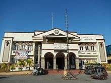
Pursuant to the Local government in the Philippines",[8][9] the political seat of the municipal government is located at the Municipal Hall. In the History of the Philippines (1521–1898), the Gobernadorcillo was the Chief Executive who held office in the Presidencia. During the American rule (1898–1946) (History of the Philippines (1898-1946)), the elected Mayor and local officials, including the appointed ones held office at the Municipal Hall. The legislative and executive departments perform their functions in the Sangguniang Bayan (Session Hall) and Municipal Trial Court, respectively, and are located in the Town Hall.
Orani, Bataan's incumbent elected officials are - Mayor Benjamin "Benjie" C. Serrano, Jr. and Vice-Mayor Godofredo Bongco Galicia, Jr., including 8 Councilors or Sanguniang Bayan Members:[10][11] Rome Serrano Sicat. Renato Rodriguez Bugay, Rodolfo Fabian Duran, Francis Sevilla Dela Torre, Efren, Jr. Luna Monday, Voltaire Dionisio Medina,Lilian Flores Tongco and Rolando Bernaldo Mina. They hold office at the second floor of the Town Hall, particularly the Office of the Mayor and Sangguniang Bayan Session Hall, respectively.
The 2nd Municipal Circuit Trial Court of Orani-Samal, MCTC Judge Ma. Cristina J. Mendoza-Pizzaro holds office in her sala located at the second floor of the MTC building at the back of the Town hall.
Educational institutions
|
|
|
Attractions

Orani's attractions, events and historical landmarks include:[12]
- Holy Rosary Parochial Institute — Mango Tree
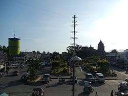
- Orani People's Park, center of Poblacion, Plaza
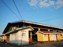
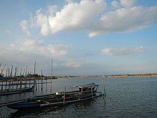
- Orani Fish Port
- The United Methodist Church
- The 1714 Orani Church, commonly known as the "Our Lady of the Most Holy Rosary Parish Church of Orani" ("Our Lady of the Rosary of Orani", "Nuestra Señora del Rosario Parish Church", "Church of Orani" or "Virgen Milagrosa Del Rosario del Pueblo de Orani Shrine") is a Neoclassical (heritage) Diocesan Marian Shrine and Pilgrimage church (recognized by the 1959 Vatican's Papal Bull, located in Poblacion).
- Orani ₱42.7 million new municipal building, located at the center of the old Poblacion, in front of the Orani Church. It has a total floor area of 2,916 square metres (31,390 sq ft), including the roof deck (648 sq. m.) On August 4, 2005, Mayor Efren Pascual Jr. constructed the building which was inaugurated on May 26, 2007.
- The Multi-purpose Gym
- Orani Cockpit
- Orani Public Market
- Death March Marker (Silahis), Bataan Death March. Kaparangan was used as a temporary prisoners’ camp by the Japanese soldiers starting on April 11, 1942, the second day of the infamous “Death March”. To commemorate the pitiful event, the National Historical Institute constructed a bronze memorial at the corner of Barangay Silahis and the Bataan National Road in 1987.
- Tamarind Ridge — a 14-hectare development situated at Barangay Tugatog, Orani, Bataan
- Bataan Peninsula State University - Orani Campus
- Pawikan Festival[13]
Gallery
-
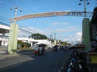
Welcome arch
-

Public market
-
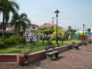
Park and plaza
-
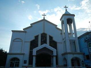
Saint John the Evangelist Parish Church
-
The bamboo makeshifts
References
- ↑ "Municipality". Quezon City, Philippines: Department of the Interior and Local Government. Retrieved 31 May 2013.
- 1 2 "Province: Bataan". PSGC Interactive. Makati City, Philippines: Philippine Statistics Authority. Retrieved 21 November 2016.
- 1 2 3 4 5 "Region III (CENTRAL LUZON)". Census of Population (2015): Total Population by Province, City, Municipality and Barangay (Report). PSA. Retrieved 20 June 2016.
- 1 2 3 "2016 National and Local Elections Statistics". Commission on Elections. 2016.
- ↑ "Municipal: Orani, Bataan". PSA. Philippines: National Statistical Coordination Board. Retrieved 8 January 2016.
- 1 2 "Region III (CENTRAL LUZON)". Census of Population and Housing (2010): Total Population by Province, City, Municipality and Barangay (Report). NSO. Retrieved 29 June 2016.
- ↑ "Region III (CENTRAL LUZON)". Census of Population (1995, 2000 and 2007): Total Population by Province, City and Municipality (Report). NSO. Archived from the original on 24 June 2011.
- ↑ "Philippines : Gov.Ph : About the Philippines :". Gov.ph. Retrieved 2009-03-28.
- ↑ "the Local Government Code of the Philippines (Republic Act No. 7160)". Chan Robles Virtual Law Library. Retrieved 6 December 2016.
- ↑ "Municipality of Orani". Provincial Government of Bataan. Archived from the original on 2 April 2012. Retrieved 21 November 2016.
- ↑ "Orani, Bataan Candidates". Know Your Candidates. Archived from the original on 14 October 2010. Retrieved 6 December 2016.
- ↑ "Orani's Historical Landmarks". Municipality of Orani. 17 November 2010. Archived from the original on 8 December 2013. Retrieved 21 November 2016.
- ↑ Pawikan Festival 2012 Orani Bataan. YouTube. 30 November 2012. Retrieved 15 July 2015.
External links
| Wikimedia Commons has media related to Orani, Bataan. |
- Orani on MyBataan
 |
Hermosa | | ||
| Morong | |
Manila Bay | ||
| ||||
| | ||||
| Samal |
Balanga (capital) | |
| Municipalities | |
| Component city | |