Orient Heights (MBTA station)
ORIENT HEIGHTS | |||||||||||
|---|---|---|---|---|---|---|---|---|---|---|---|
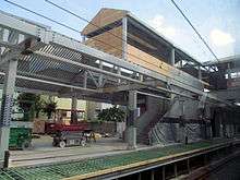
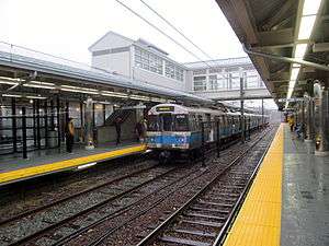 Newly reopened station in November 2013 | |||||||||||
| Location |
1000 Bennington Street East Boston, Massachusetts | ||||||||||
| Coordinates | 42°23′14″N 71°00′15″W / 42.3871°N 71.0042°WCoordinates: 42°23′14″N 71°00′15″W / 42.3871°N 71.0042°W | ||||||||||
| Owned by | Massachusetts Bay Transportation Authority | ||||||||||
| Line(s) | |||||||||||
| Platforms | 2 side platforms | ||||||||||
| Tracks | 2 | ||||||||||
| Construction | |||||||||||
| Parking |
434 spaces ($5.00 fee) 2 accessible spaces | ||||||||||
| Bicycle facilities | 8 spaces | ||||||||||
| Disabled access | Yes | ||||||||||
| History | |||||||||||
| Opened |
1875 (BRB&L) January 5, 1952 (rapid transit)[1] | ||||||||||
| Closed | 1940 (BRB&L) | ||||||||||
| Rebuilt | March 23 - November 26, 2013[1] | ||||||||||
| Traffic | |||||||||||
| Passengers (2013) | 2,833 (weekday average boardings; may be affected by 2013 closure)[2] | ||||||||||
| Services | |||||||||||
| |||||||||||
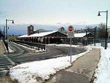
Orient Heights is a rapid transit station on the MBTA Blue Line located off Bennington Street in East Boston, Massachusetts. Formerly a Boston, Revere Beach and Lynn Railroad station under various names from 1875 to 1940, it reopened in 1952. The 1952-built station was closed in March 2013 for a complete rebuilding to provide full handicapped accessibility and reopened on November 26, 2013.[3]
Orient Heights station is the primary rapid transit connection for the Orient Heights neighborhood of East Boston, as well as for Winthrop. It also serves as a bus transfer station, with three routes connecting Winthrop and Orient Heights. Orient Heights Yard, the main Blue Line yard, branches off the main line just north of the station. Because of the proximity, Blue Line employees report to work at Orient Heights station.
History
BRB&L era
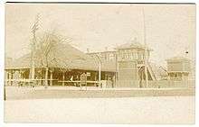
The narrow gauge Boston, Revere Beach and Lynn Railroad (BRB&L) opened from East Boston to Lynn on July 29, 1875.[4] The BRB&L opened with Orient station, located north of the intersection of Bennington and Saratoga Street.[4] It was soon replaced with Winthrop station located closer to Saratoga Street.[5][6]
The station was renamed as Winthrop Junction in 1877 when the Boston, Winthrop, and Point Shirley Railroad opened to Winthrop Center, and again as Orient Heights in April 1892.[5][7] The station was the transfer point between the main line and the Winthrop Center branch during its short operation from 1877 to 1885, and between the main line and the Winthrop Loop after the latter's 1888 opening.[8]
By 1928 the line was electrified, with pre-pay stations - more a rapid transit line than a conventional railroad.[9] However, due to the Great Depression, the BRB&L shut down on January 27, 1940.[8]
MBTA era
In 1941, the Boston Elevated Railway bought the BRB&L right of way from Day Square to Revere Beach for use as a high-speed trolley line similar to the Ashmont-Mattapan High Speed Line; these plans were delayed by the onset of World War II.[7] However, the 1926 Report on Improved Transportation Facilities and 1945–47 Coolidge Commission Report recommended that the East Boston Tunnel line, which had been converted to rapid transit from streetcars in 1924, be extended to Lynn via the BBRB&L route rather than using it for a trolley line.[10][11]
In 1947, the newly formed Metropolitan Transit Authority (M.T.A.) decided to build to Lynn as a rapid transit line, and construction began in October 1948.[7] The first part of the Revere Extension opened to Orient Heights on January 5, 1952, with intermediate stations at Airport Station and Day Square.[1] The station was the terminus of the line until April 21, 1952, when Suffolk Downs station opened. Until September 1972, some trains terminated at Orient Heights rather than Wonderland to provide more frequent service on the inner part of the line.[1]
During temporary construction and track work on the outer section of the line and during severe weather conditions, Orient Heights is sometimes used as the terminus, as its busways can accommodate the replacement bus service. From June 25, 1994 to June 24, 1995, Orient Heights was the terminus at all times to permit reconstruction of the outer stations as part of the Blue Line Modernization Program.[1][12][13]
Rebuilding
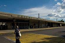
Until 2012, Orient Heights was the only Blue Line station in East Boston that had not yet been fully rebuilt (since its 1952 opening) for better accessibility. (The only others on the line were Government Center and Bowdoin, both in downtown Boston). Due to this distinction, until then it was the last remaining station in the MBTA that still had a 1967 system map, which showed the Charlestown and Washington Street Elevateds on the Orange Line and the Green Line "A" Branch.[14] The station was literally falling apart, with the sagging platforms held up by 2x4s.
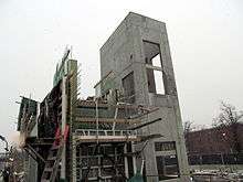
On October 5, 2011, the MBTA announced a $51 million ground-up rebuild of the station. The $51 million reconstruction of the crumbling station was expected to be paid for mostly by the Federal Transit Administration.[14][15] Construction began in earnest in mid-2012 with the demolition of much of the 1952 station and the erection of temporary platforms. The first inbound elevator shaft was built in November 2012, with the first outbound shaft following soon after.
The station closed on March 23, 2013, so that the remainder of the old station could be demolished and the new station built. Bus shuttles operated from Suffolk Downs during the closure, which ended on November 23, 2013.[1][3]
Bus connections
Three MBTA Bus routes operate out of Orient Heights:[16]
- 120 Orient Heights Station - Maverick Station via Bennington Street
- 712 Orient Heights Station - Point Shirley or Winthrop Beach via Winthrop Highlands
- 713 Orient Heights Station - Point Shirley or Winthrop Beach via Winthrop Center
Route 120 buses use the Bennington Street busway on the inbound side of the station. Route 712 and 713 buses - privately operated lines with MBTA numbers - use the Saratoga Street busway on the outbound side.
Station layout
| Platform level | Side platform, doors will open on the right | |
| Southbound | ← Blue Line toward Bowdoin or Government Center (Wood Island) | |
| Northbound | → Blue Line toward Wonderland (Suffolk Downs) → | |
| Ground | - | Exit/Entrance |
References
- 1 2 3 4 5 6 Belcher, Jonathan (27 June 2015). "Changes to Transit Service in the MBTA district 1964-2015" (PDF). NETransit. Retrieved 24 December 2015.
- ↑ "Ridership and Service Statistics" (PDF) (14 ed.). Massachusetts Bay Transportation Authority. 2014. Retrieved 14 July 2014.
- 1 2 Rocheleau, Matt (25 November 2013). "MBTA set to reopen Orient Heights subway station after 8-month closure". Boston Globe. Retrieved 25 November 2013.
- 1 2 Bradlee, Francis Boardman Crowninshield (1921). The Boston, Revere Beach and Lynn Narrow Gauge Railroad. Essex Institute. pp. 4–5 – via Google Books.
- 1 2 Stanley, Robert C. (1980). Narrow Gauge: The Story of the Boston, Revere Beach & Lynn Railroad. Boston Street Railway Association.
- ↑ G.W. Bromley and Co. (1912). "Charlestown & East Boston 1912 Index Plate". Atlas of the City of Boston: Charlestown and East Boston. WardMaps LLC. Retrieved 13 September 2012.
- 1 2 3 Cheney, Frank (2003). Boston's Blue Line. Arcadia Publishing. pp. 8, 64, 83. ISBN 9780738535760.
- 1 2 Karr, Ronald Dale (1995). The Rail Lines of Southern New England. Branch Line Press. pp. 268–271. ISBN 0942147022.
- ↑ ""Narrow Gage" Electrified for Economy". Electric Railway Journal. 72 (23): 991–998. 8 December 1928. Retrieved 24 December 2015 – via Internet Archive.
- ↑ Central Transportation Planning Staff (15 November 1993). "The Transportation Plan for the Boston Region - Volume 2". National Transportation Library. Retrieved 3 July 2012.
- ↑ Boston Elevated Railway and Boston Department of Public Utilities (1945), Boston Rapid Transit System & Proposed Extentions 1945 - Metropolitan Transit Recess Commission Air View
- ↑ Blake, Andrew (20 March 1994). "MBTA to begin $467 million Blue Line project". Boston Globe. Retrieved 26 January 2014 – via Highbeam Research. (subscription required (help)).
- ↑ Blake, Andrew (18 June 1995). "Blue Line Stations Set to Reopen After $467M Upgrade". Boston Globe. Retrieved 4 July 2015 – via Highbeam Research. (subscription required (help)).
- 1 2 Moskowitz, Eric (6 October 2011). "MBTA board OK's millions for stations". Boston Globe. Retrieved 24 December 2015.
- ↑ Rocheleau, Matt (25 February 2013). "MBTA to close Orient Heights subway station on Blue Line for nearly 7 months". Boston Globe. Retrieved 1 March 2013.
- ↑ "Orient Heights Station Neighborhood Map" (PDF). Massachusetts Bay Transportation Authority. July 2012. Retrieved 24 December 2015.
External links
| Wikimedia Commons has media related to Orient Heights (MBTA station). |
- MBTA - Orient Heights
- MBTA construction project page
- Station from Saratoga Street from Google Maps Street View
| Subway lines (List of stations) |
| |||||||||||
|---|---|---|---|---|---|---|---|---|---|---|---|---|
| Commuter Rail lines (List of stations) |
| |||||||||||
| Bus routes (List of routes) | ||||||||||||
| Other services | ||||||||||||
| Component parts of system lines | ||||||||||||
| Capital projects |
| |||||||||||
| History |
| |||||||||||
| Other | ||||||||||||